Mt. Stuart West Ridge  

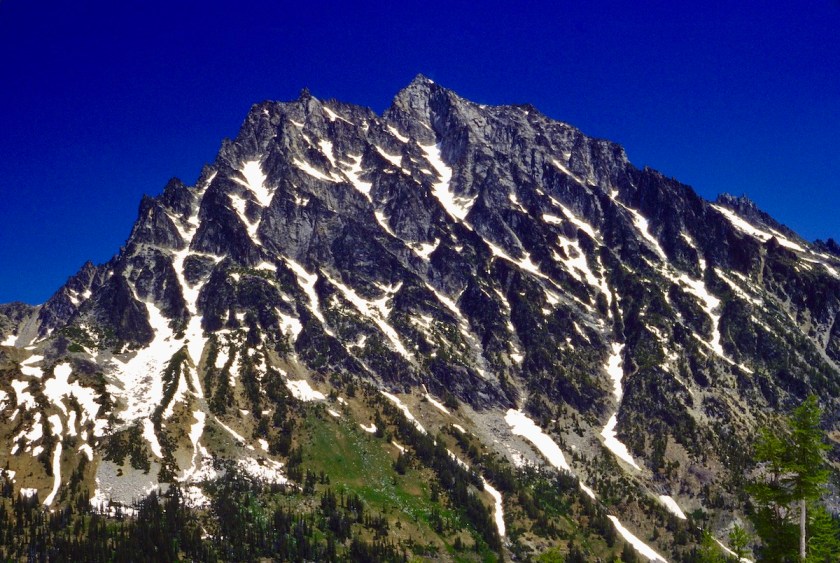
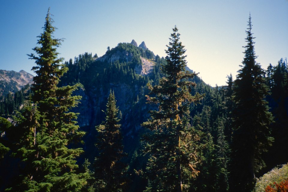
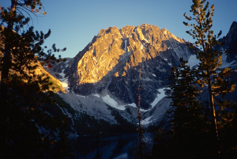
Climb –            Mt. Stuart West Ridge                                 Date(s) – July 5-8, 1996

Area/Range –  Alpine Lakes Region/Stuart Range

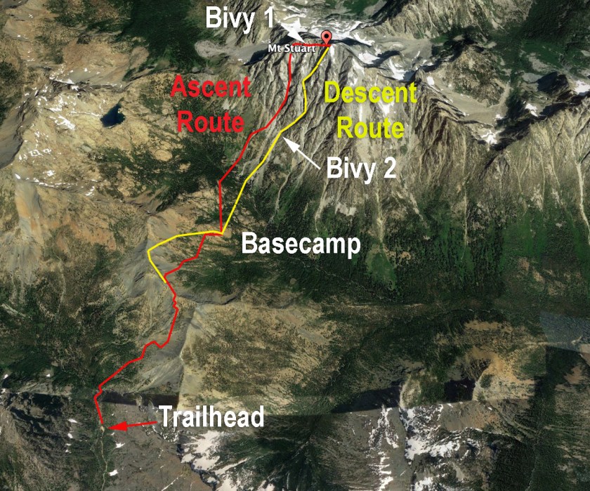
Approach Route – Surprise Lake Trailhead #1060 to Ingalls Pass

Ascent Route – West Ridge

Decent Route – West Ridge Couloir

Altitude –  9,415 feet Elevation Gain – 4,200 feet

Total Distance – 12 miles     Maps/Guides – Becky Guide, page 328, Alpine Lakes Guide page 42, Green Trails Topo #176 Stevens Pass

Times: Approach – 3 – 4 hrs. to Ingalls Creek           Ascent – 1.5 days   Decent – 1.5 days

Grade – II        Class – 5.6/5.7              Pitches – many

Equipment Used/Recommended –  2 – 60 meter ropes, stoppers & cams, long slings & extra biners, (a few pitons wouldn’t be out of place) pickets would have been useful for snow belays.

Weather – Good weather, clear skies, cold Friday, warming as weekend progressed.  Cooled down on our bivy’s to low 40’s – high 30’s

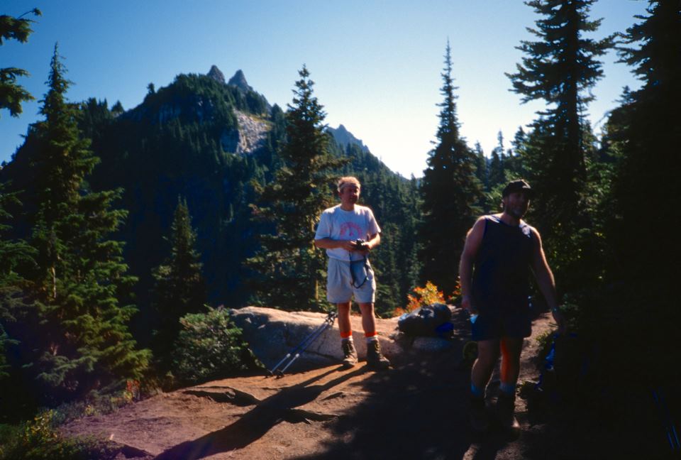
Climbing Partners – Tom, Rick, Nicole

Climb Leaders – Les Profitt    Number in Party – 4

Flora/Fauna –  Wildflowers, saw a few marmots & picas.  Lots of Goat tracks.  Saw one goat.

“Without a rival as the crown peak in the central Cascades of Washington, Mount Stuart has been pronounced the single greatest mass of exposed granite in the United States…its northern and eastern faces are the alpine climax of the Wenatchee Mountains. They make a powerful impact on first sight…The mountaineering problems are magnified by the mountain’s massive dimensions and its complexity.” “Cascade Alpine Guide” by Fred Beckey.

Quote from Rick Baker during the climb: “Beckey is one lying-ass MF!”

This recollection/trip report from one of my climbing logs was written right after we returned from the climb back in 1996.  It has gotten dusty and moldy over the last 25 years, but I cleaned it up and added photos from the trip. 

====================================================

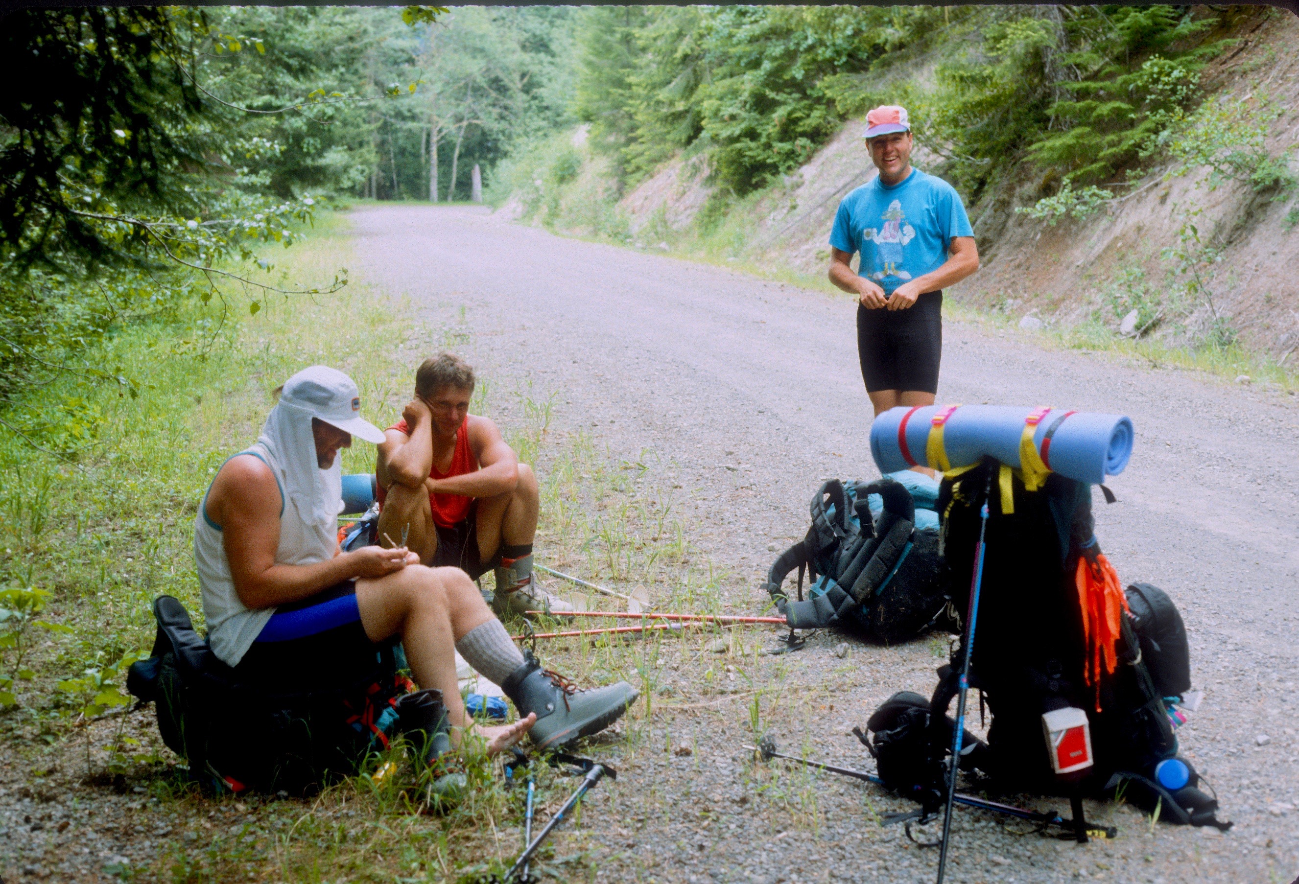
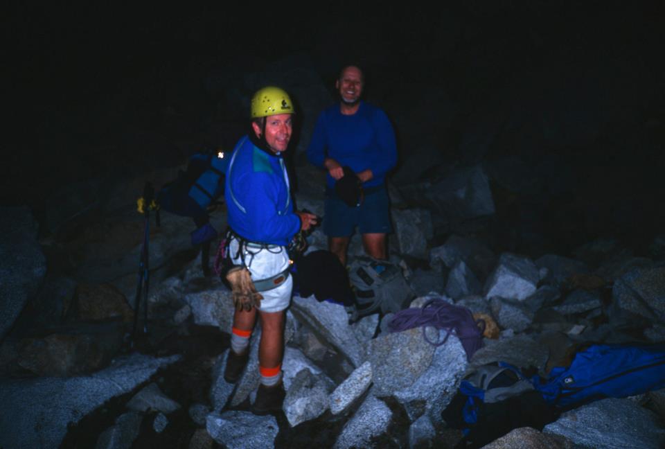
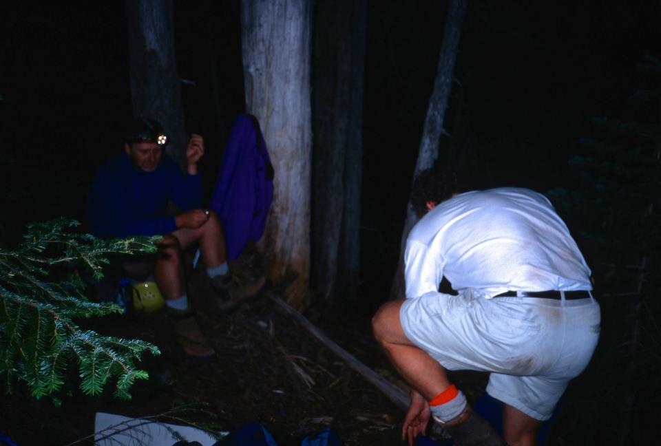
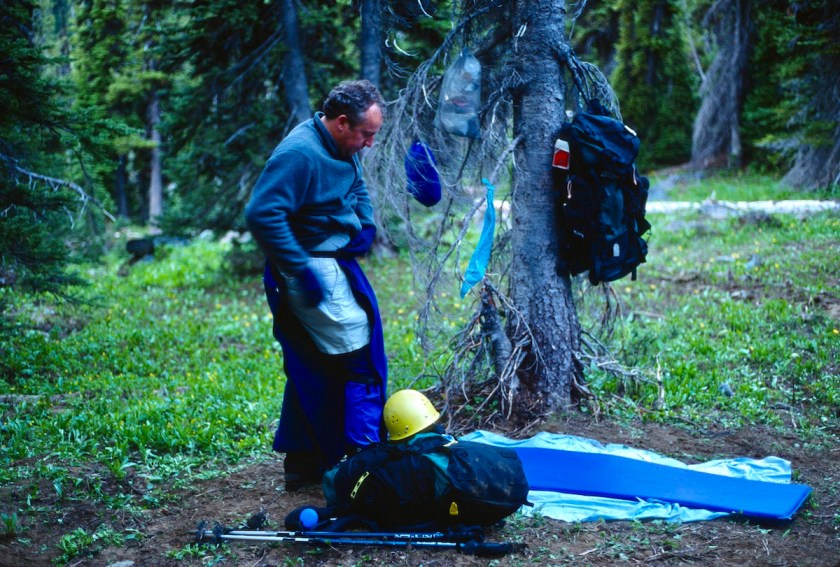
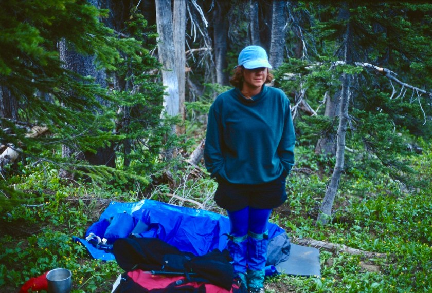
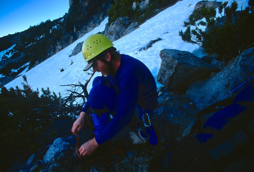
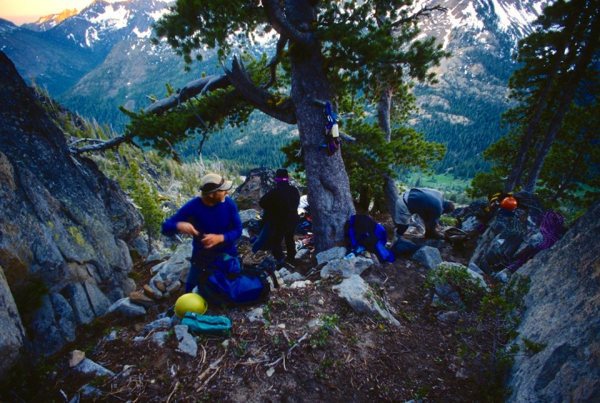
After celebrating the 4th of July the day before, we met at Rick’s house around noon on Friday and headed over to Alpine Experience to get a bivy sack for Tom.  I had decided I wasn’t taking a sleeping bag and Tom decided to join me and get a bivy sack.

Rick said the hell with that, he was taking his sleeping bag.  I decided I needed to go through his pack and take out some stuff I already had or he didn’t need. That boy could squirrel away more shit than he ever uses (he was packing a half gallon of bourbon and 2 full rolls of TP on top of everything else).

Scan-130223-0001
Tom and Rick with Tom’s old Mazdarati at the Teanaway Trailhead getting packs ready.

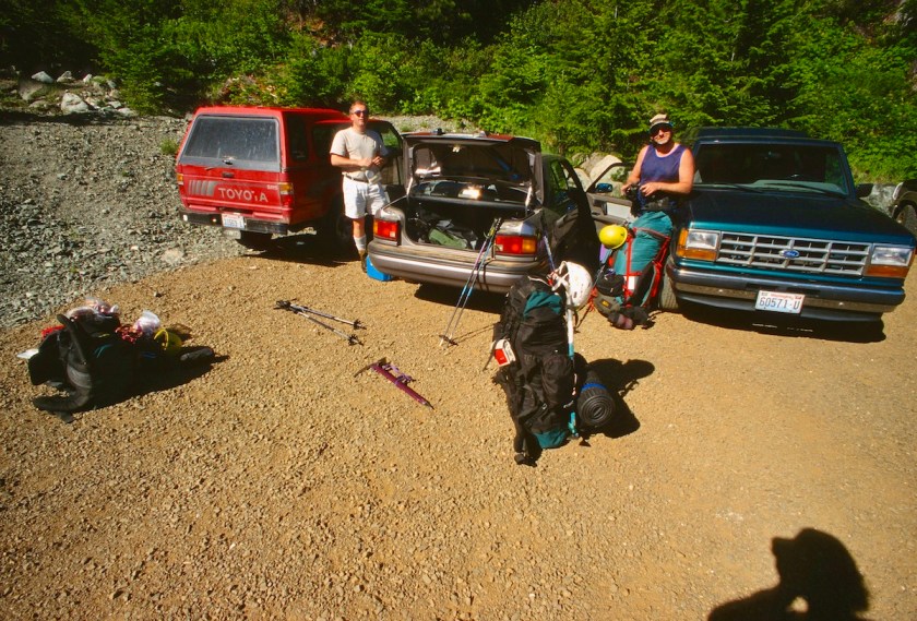
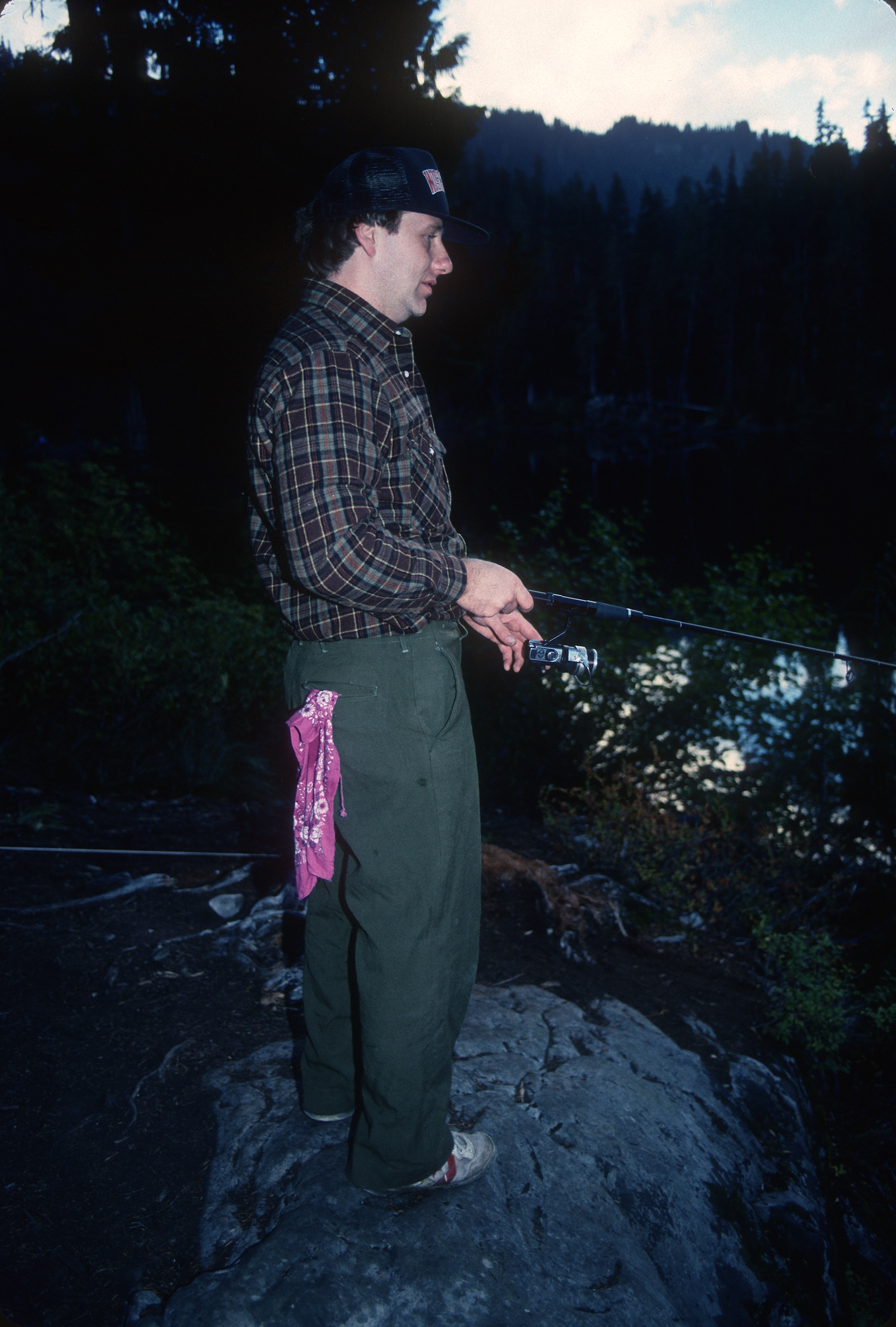
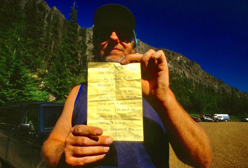
The drive over to the east side of the mountains from Olympia was uneventful. We arrived at the trail head somewhere around 3:30 or 4:00 and found a note on the trailhead bulletin board that Nicole, our 4th,  had gone up the trail the day before saying that she had a stove and bottle of fuel with her to camp out at Ingall’s pass.

Scan-130223-0002
Note Nik left on bulletin board

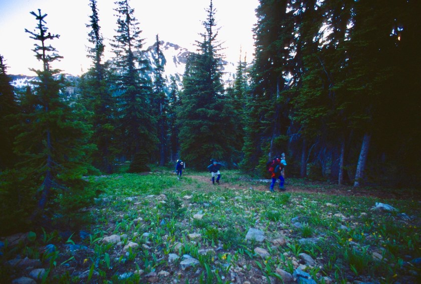
We made it up the mountain to the pass in a couple of hours with Rick dragging ass with all the shit he was still carrying and just because he was Rick.

Scan-130223-0004
View of Mt Stuart from top of the pass

I cruised a little faster and found Nicole sleeping in a group of trees.  She had her stuff spread out all over the place and I told her we planned to keep going to get down into the big bowl below the West Ridge before nightfall.

She had been playing that morning and did Ingall’s Peak with some folks she met up there.  While she was packing her stuff I dropped my pack and went back to see what was taking Tom and Rick so long. Tom had waited at the pass to make sure Rick was on the right path, he was still moving pretty slow.

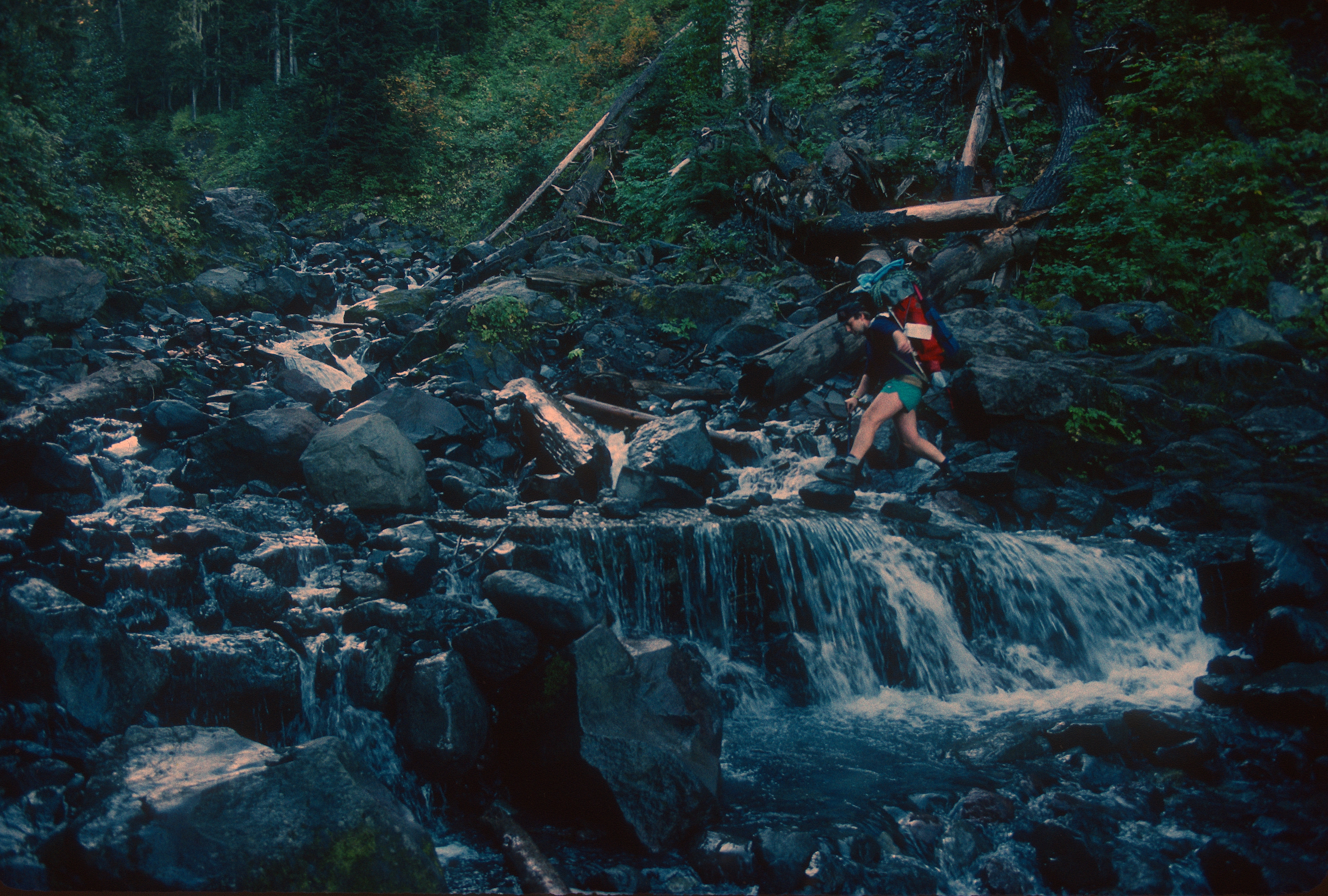
We all saddled up and headed cross-country across the snow covered slopes.  We descended down into the bowl below Ingall’s lake (which was still frozen over) and proceeded to beat the bushes and cross snow and rock slabs to a site just the other side of Ingall’s Creek.

It was about 9:00 PM by the time we dropped our packs and we were all pretty tired from the snow covered cross-country work.

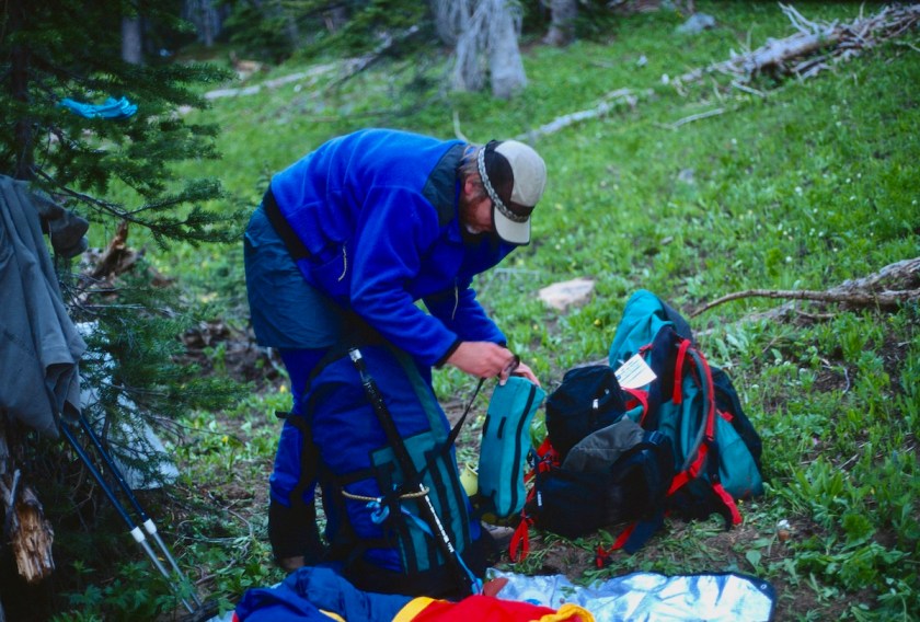
We unrolled our sleeping gear, with Rick and Nicole playing up the fact that it was getting chilly and boy were they glad they had their sleeping bags.  Tom and I put on our fleece and tried to play hardman with gritted teeth.

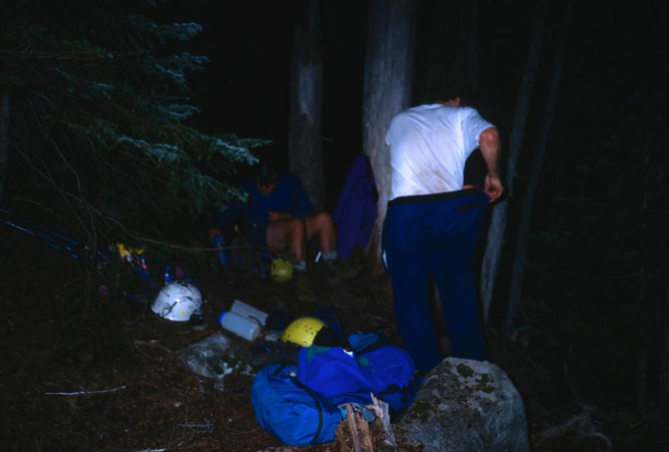
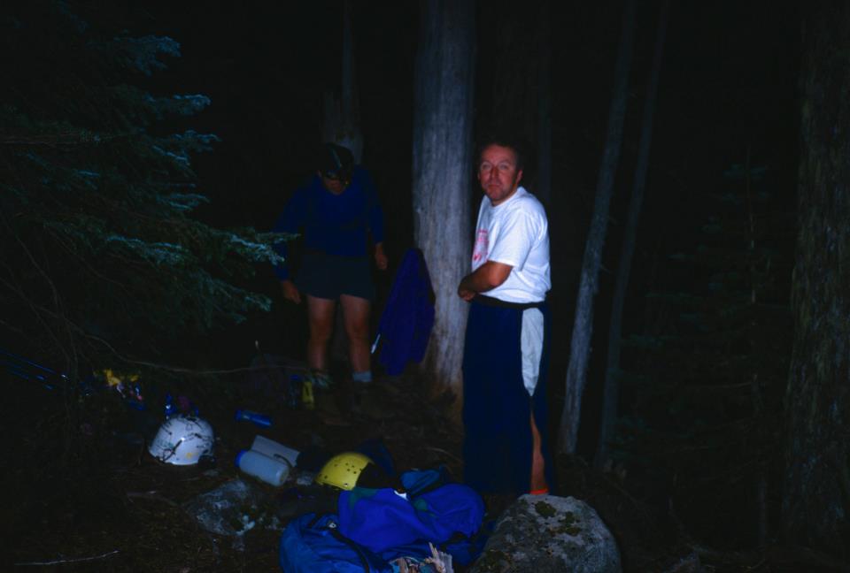
We cooked some dinner and sipped a little bourbon and turned in for the night after getting our stuff together for the climb the next morning.

Scan-130223-0005
Cranking the stove up for a late dinner

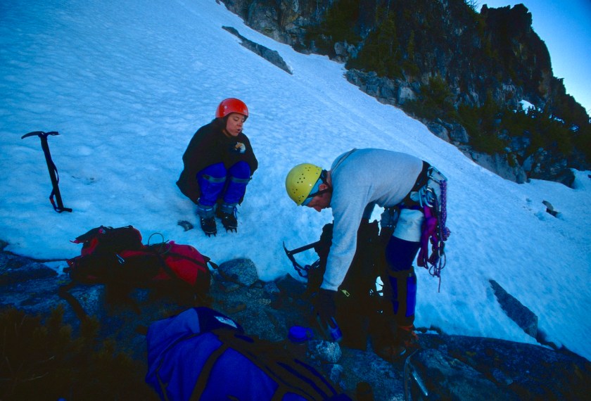
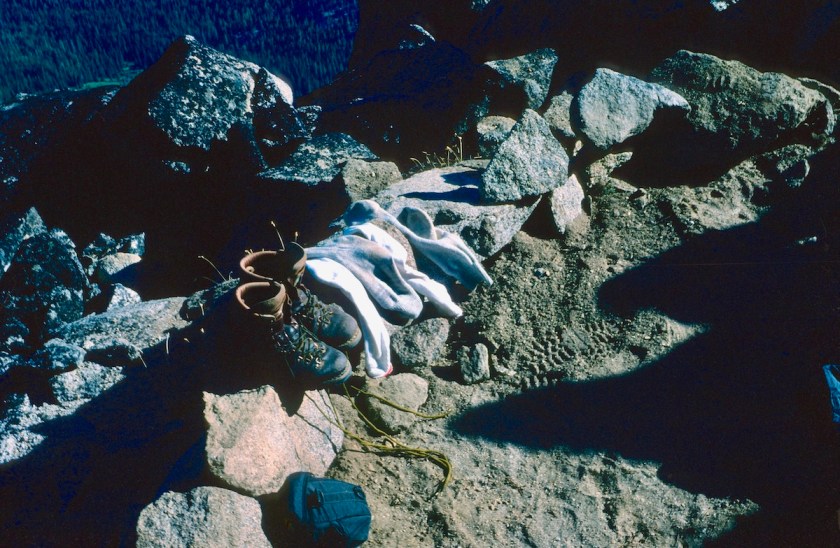
I woke everyone around 5:00 AM and we got the last of our gear together and had a quick breakfast. Tom said the bivy sack thing sucked, his feet got damn cold.  I knew he had hardly snored all night so he must have been cold!

Scan-130223-0009
Tom getting his fleece pants on in the chilly morning.

I got a little chilly, but I had put on fresh socks so my feet weren’t too cold.  Of course Rick and Nicole complained about how hot they had gotten during the night, poor babies.

Scan-130223-0008
Rick getting his gear packed up
Scan-130223-0010
Nicole ready to go

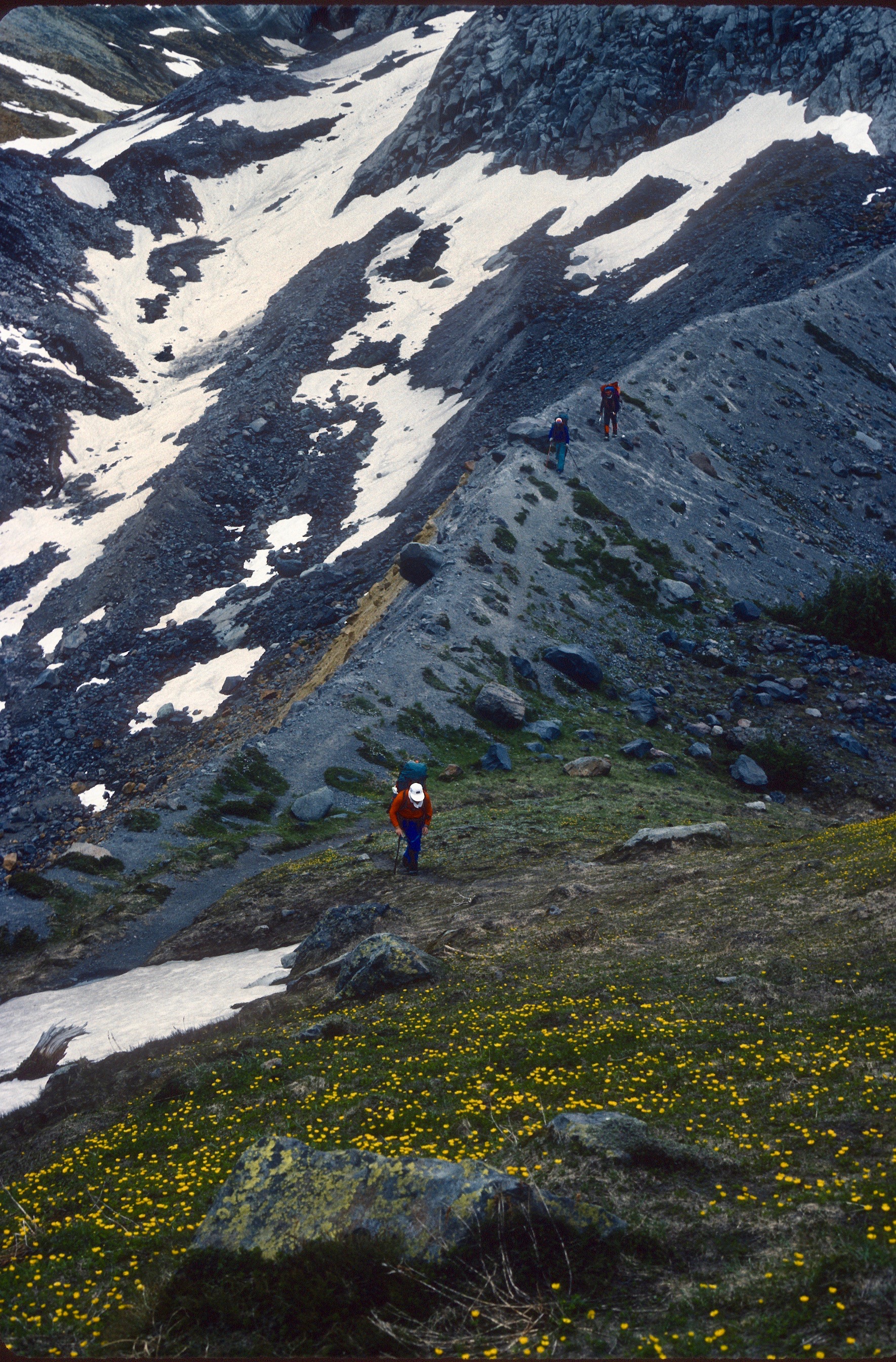
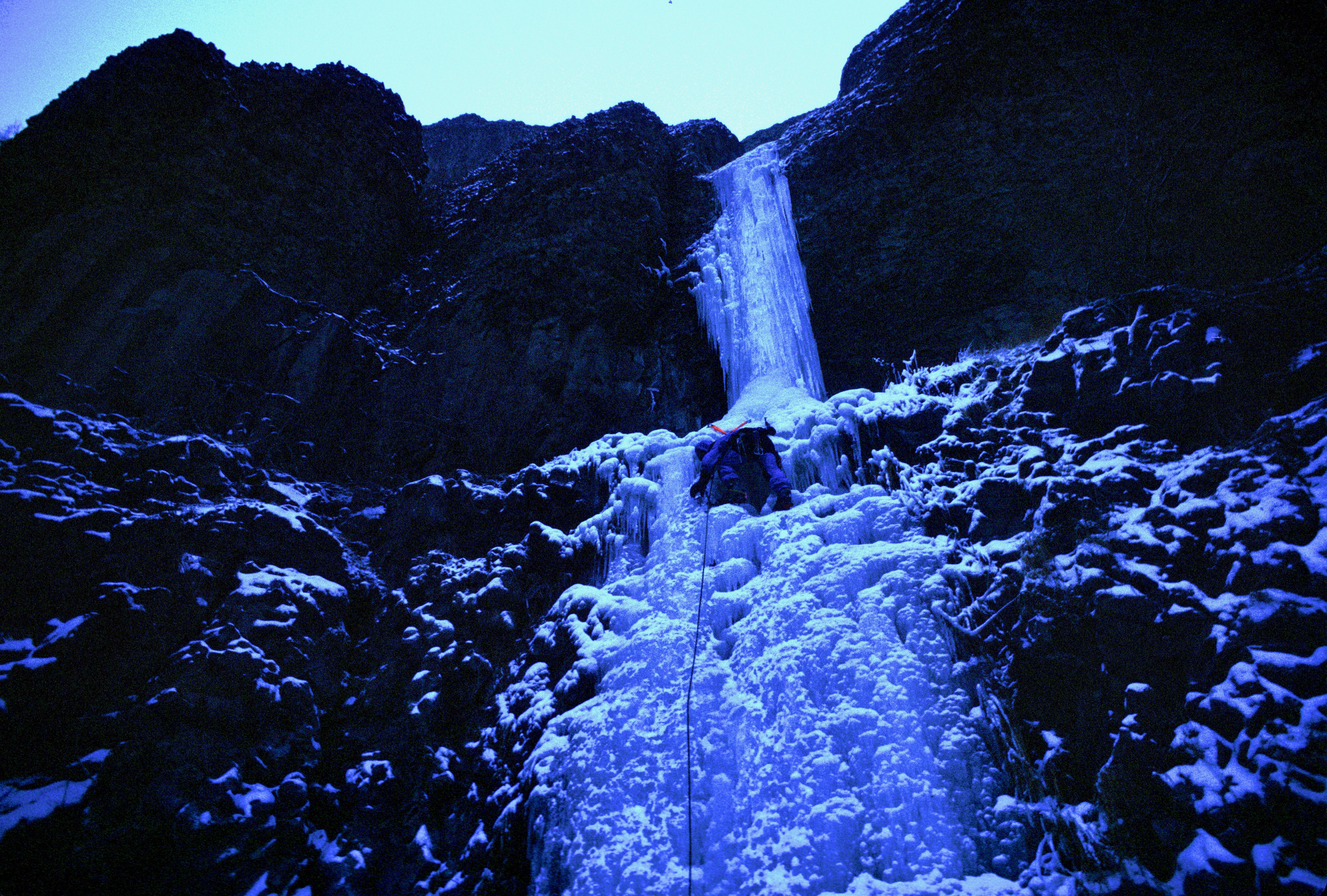
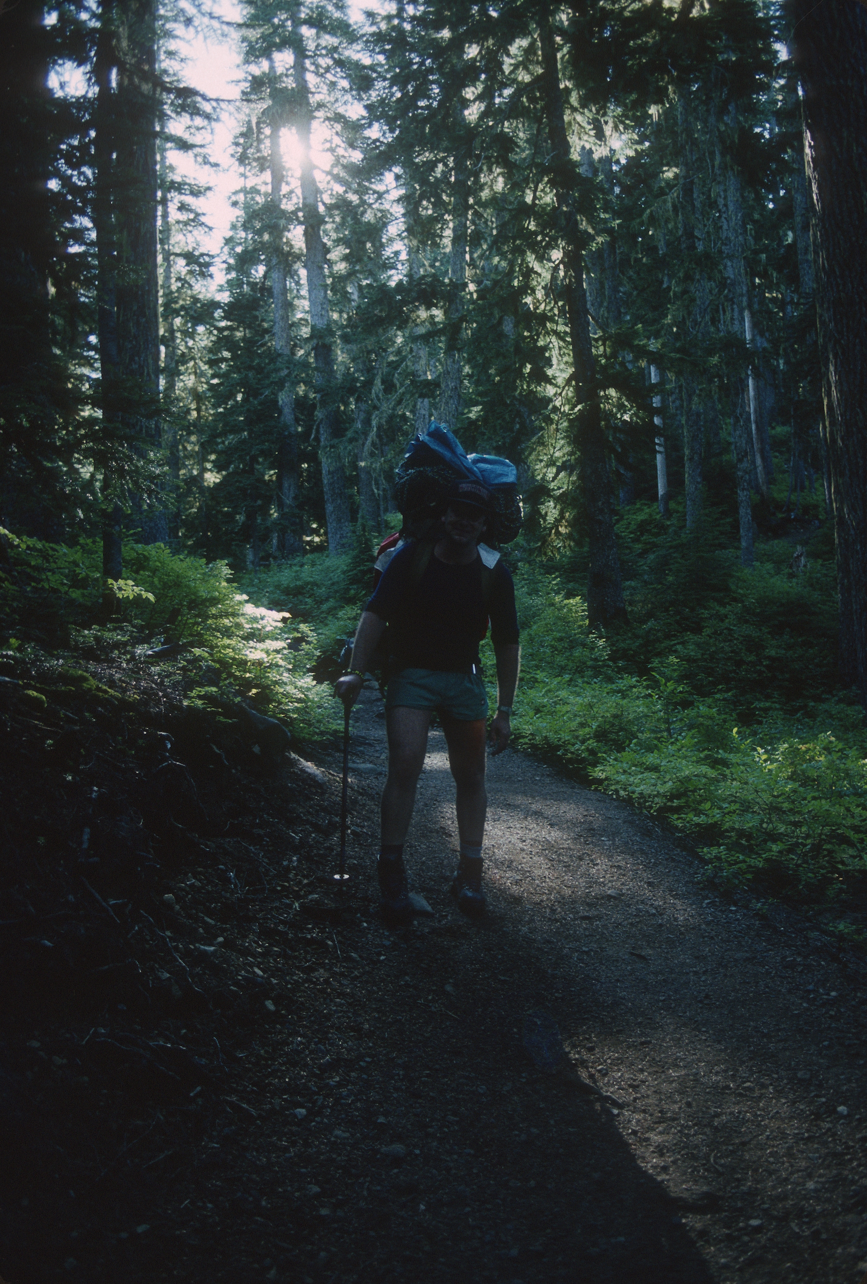
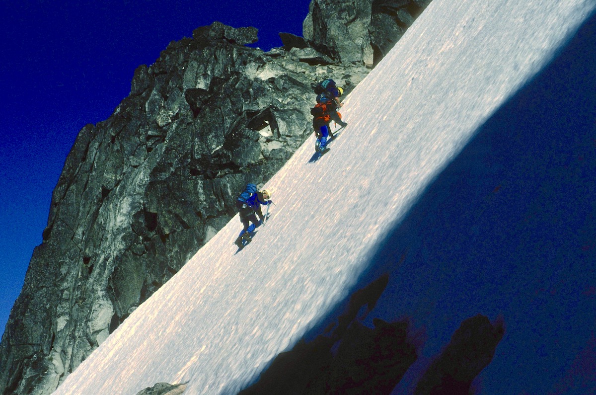
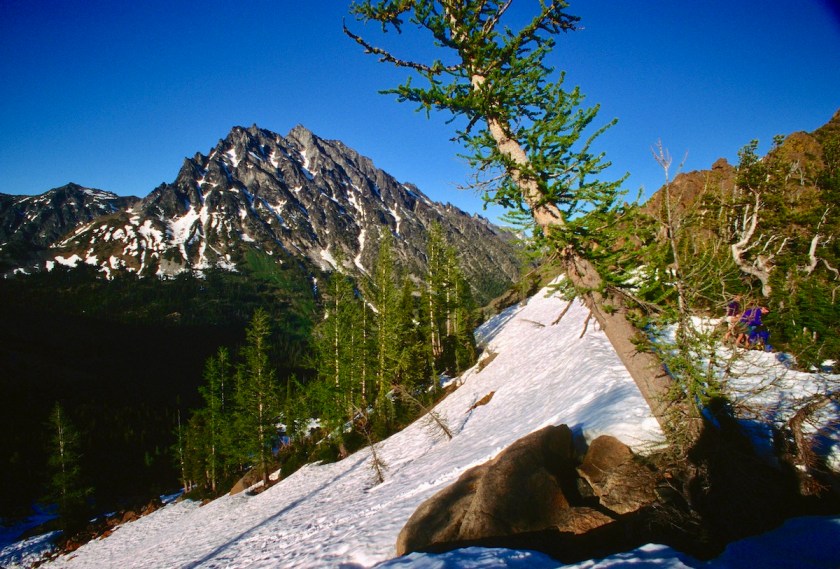
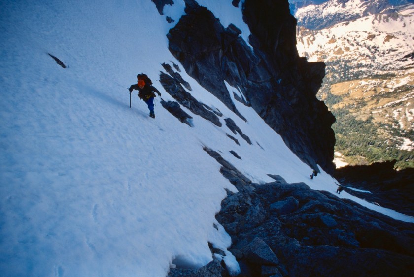
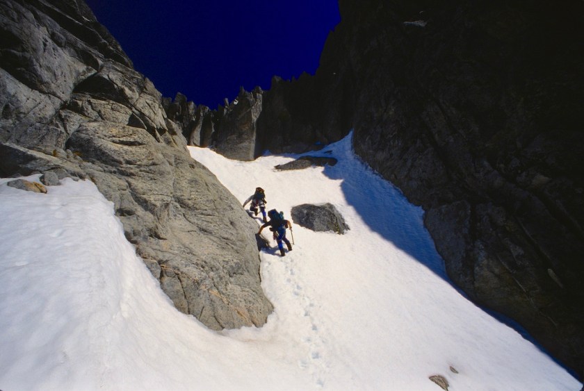
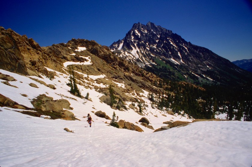
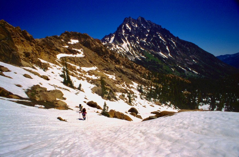
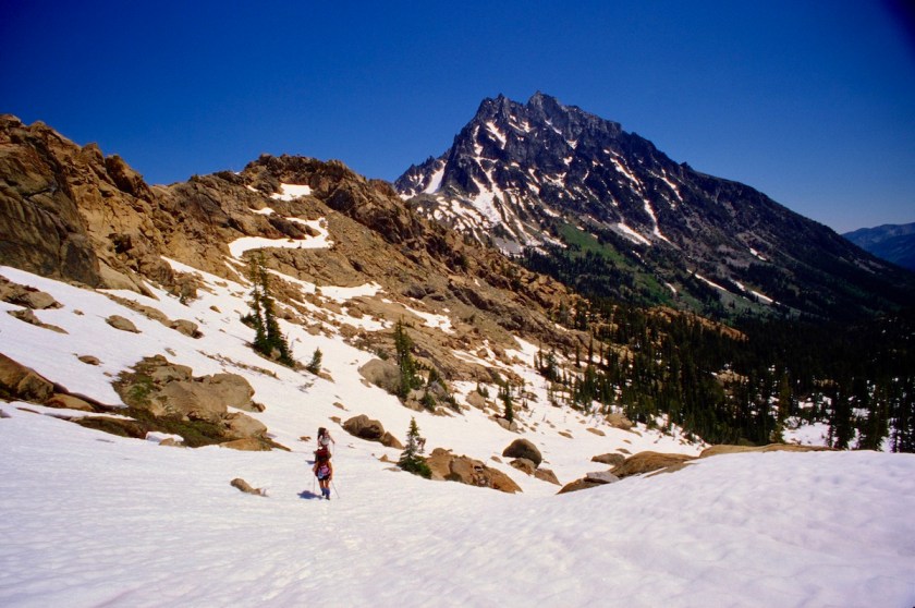
We moved out and headed up the steep, open meadows and talus to the first continuous gully east of the west ridge.

Scan-130223-0011
Slogging up through the meadows and brush
Scan-130223-0013
Time for the fleece to come off

It was full of snow, unlike the last time we tried the route two years prior.  It had been a heavy snow pack year and the mountain was still piled high with snow in the ravines.

Scan-130223-0014
Getting crampons and ice axes ready to his the ice slopes

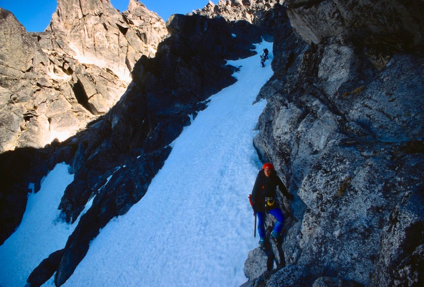
We put on crampons and headed up the steep, hard snow.  It was steep enough that a slip would find you all the way back at the bottom.

Scan-130223-0016
Looking up the gully towards the top

We didn’t rope up because a fall would just have pulled the rest of the team off as well.  It was every person for themselves.

Scan-130223-0017
Cramping up the hard ice

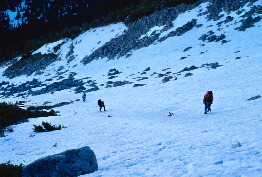
The slope continued to get steeper until we were almost front pointing with our crampons and using our axes for hand holds.

Scan-130224-0006
Nik waiting for Tom and Rick

Rick had been having problems keeping his crampons tight, in fact I had told him at our last break to make sure they were adjusted properly because the next slope was no place to blow a crampon.  Of course he promptly lost a crampon when he was on a steep pitch.

I had just made it to an ice covered rock ledge when Rick started cussing and said his crampon had come off.  I didn’t have a rope on me so I had to wait for Tom to get up to the ledge.

In the meantime I set up a couple of cams and slings for an anchor.  Tom got up to me and I tossed the rope down to Rick, who was unable to move at all.  His calves were beginning to cramp from the strain of keeping his one set of points in.

One slip and he would be off on a run that would go at least 600 feet. Rick tied in while trying to keep his balance on the ice slope and finally managed to get his crampon back on.  All this took about an hour or so.

Scan-130224-0001
Rick cinching down his crampons after blowing one out
Scan-130224-0002
Taking a short rest
Scan-130224-0004
Beautiful summer day…with plenty of frozen snow and ice

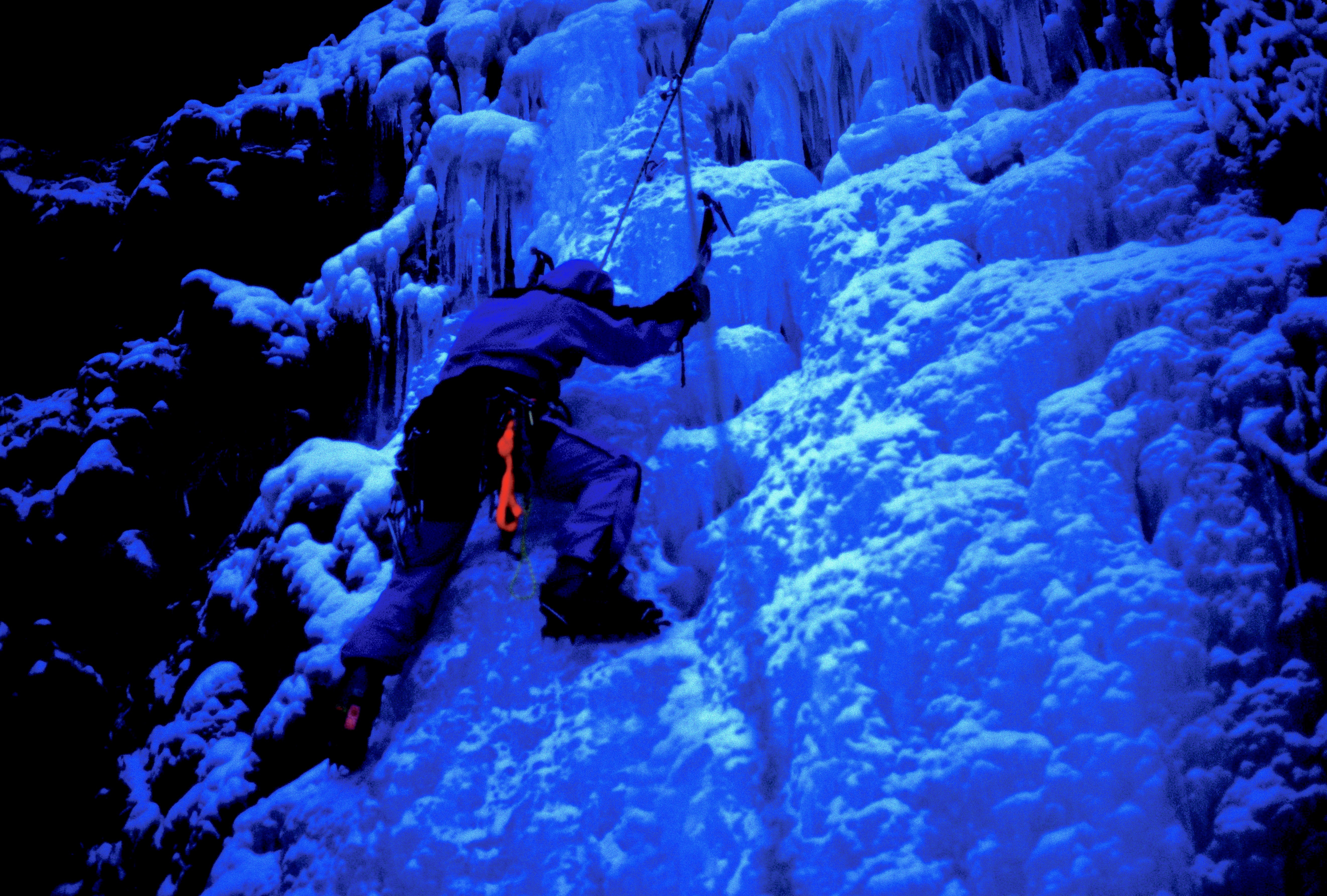
After the excitement, we continued up even steeper ice, higher and higher up the mountain.

Scan-130224-0007
Tom belaying Rick up past a steep spot

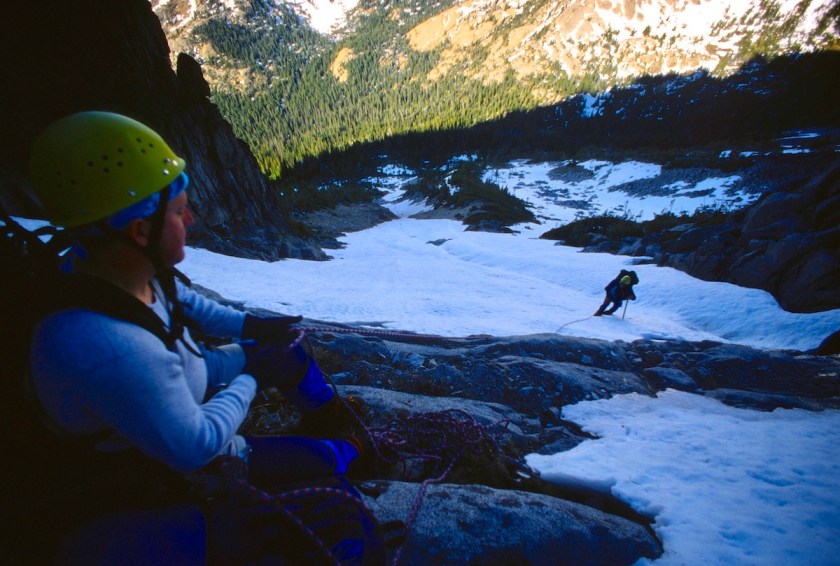
The gully seemed to go on forever and our calves were beginning to feel strained.  I had decided to just tie the rope to me and drag it up after me in case someone else lost a crampon or something.  I could feel the extra drag from below for sure!

Scan-130224-0009
Getting really steep now…

The snow was so steep and hard that there was little hope of self arresting.  A fall would be all the way to the bottom.  It was rather intimidating with all the exposure.

Scan-130224-0011
Nik looking back where she does not want to fall…
Scan-130224-0014
The lads gaining ground.
Scan-130224-0012
Nicole continuing up while I wait on Tom and Rick
Scan-130224-0018
Last little bit in the shade before hitting the ridge crest

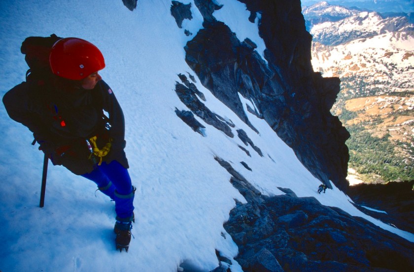
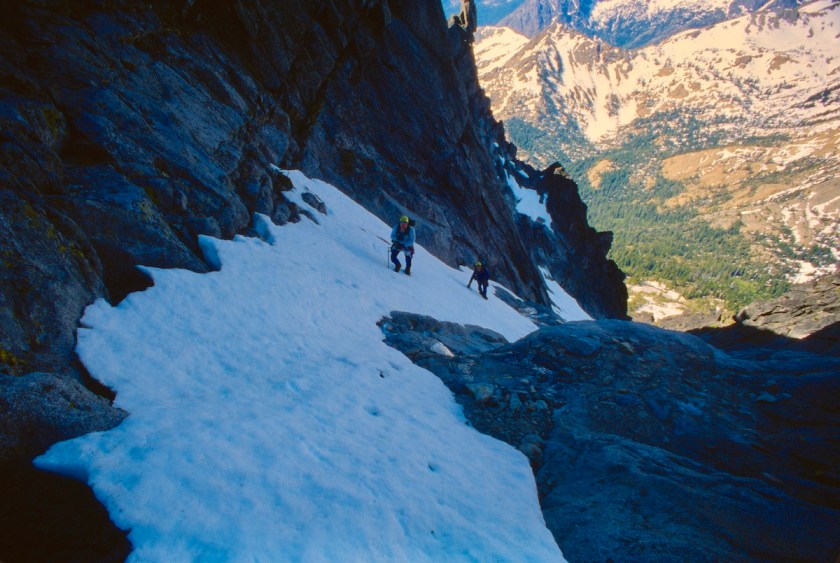
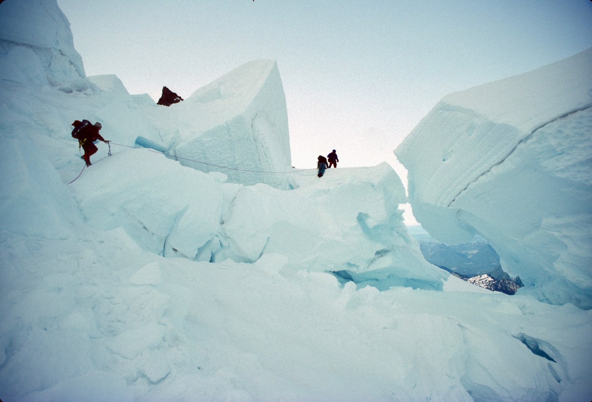
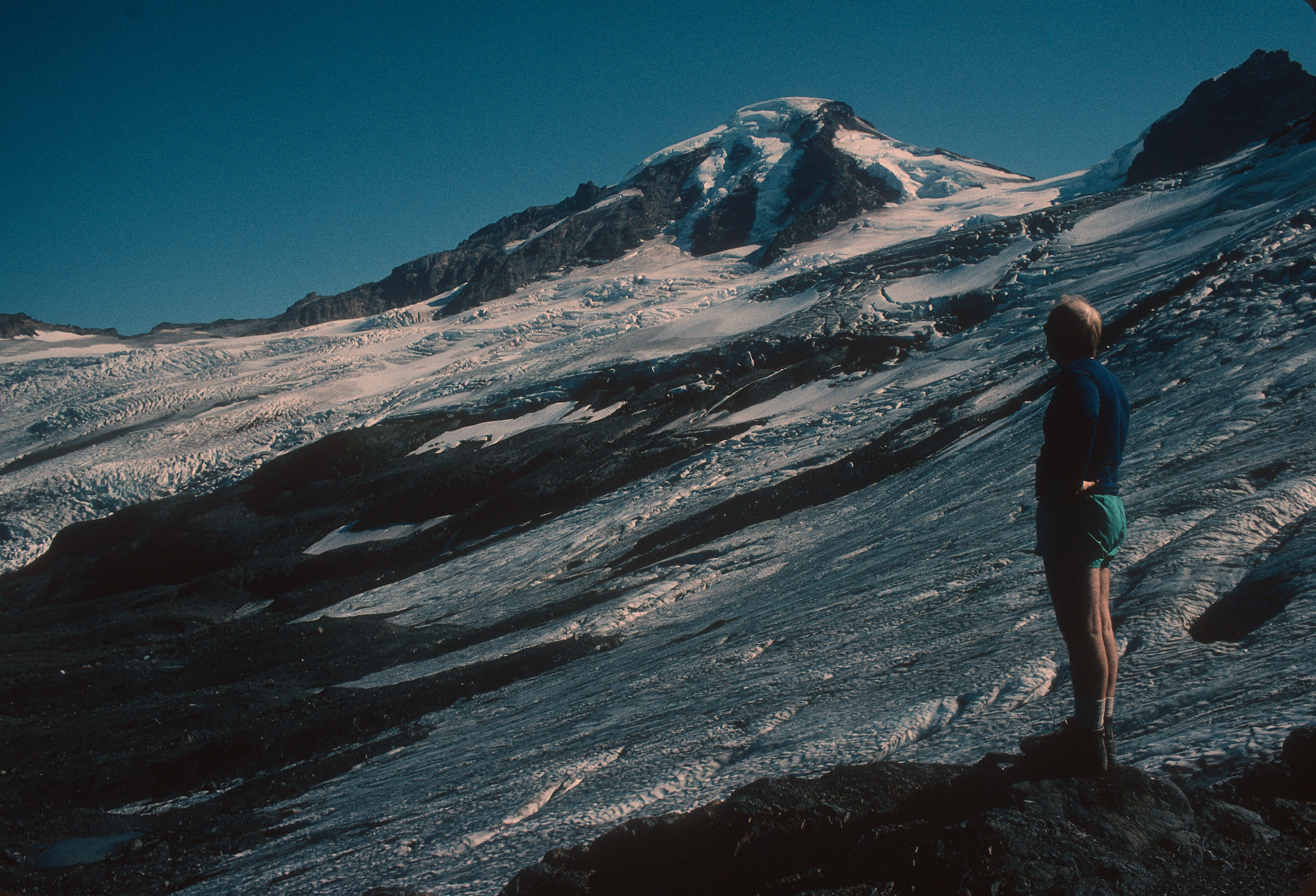
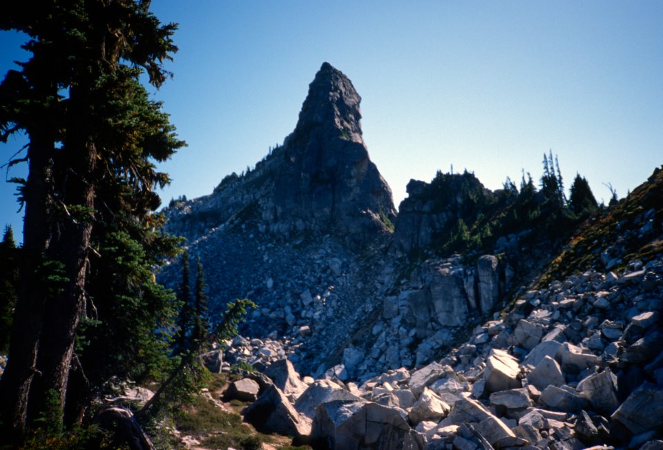
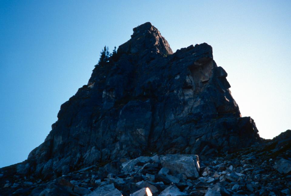
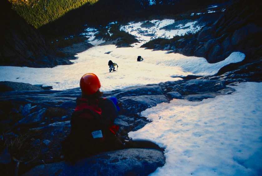
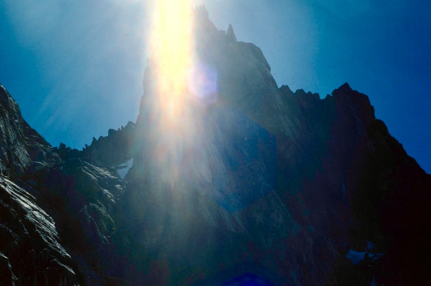
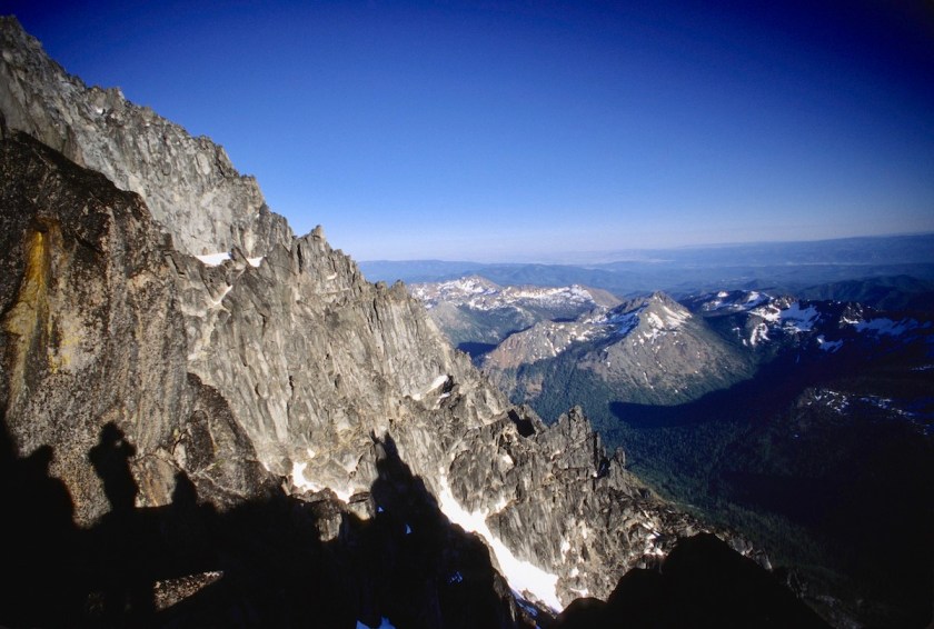
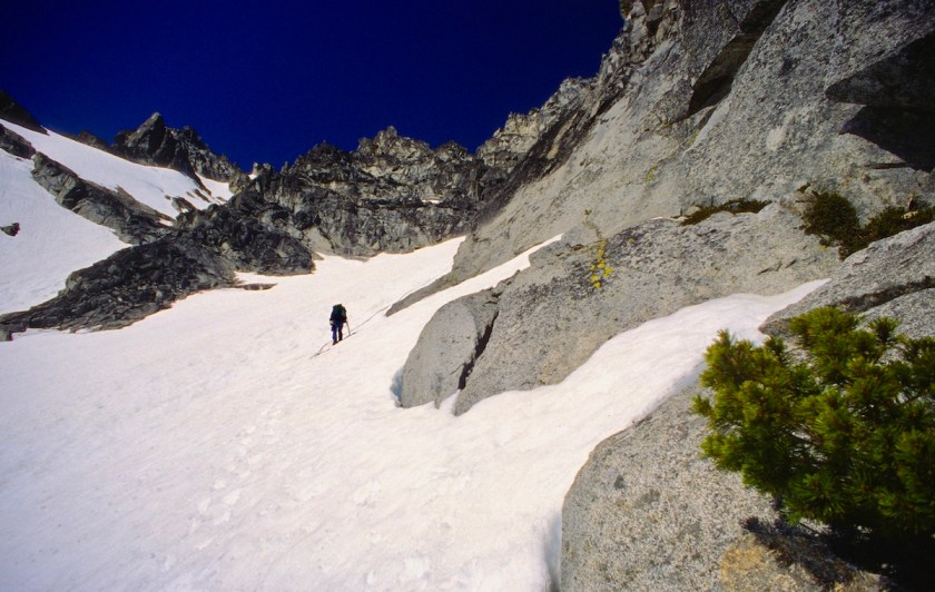
Finally we made it to the crest of the West Ridge, which was composed of loose rock mixed with large patches of snow.  At least we were in the sun instead of the shady gully.

Scan-130224-0019
Sun feels good at last on the ridge crest.
Scan-130224-0021
You can see how steep the terrain is.

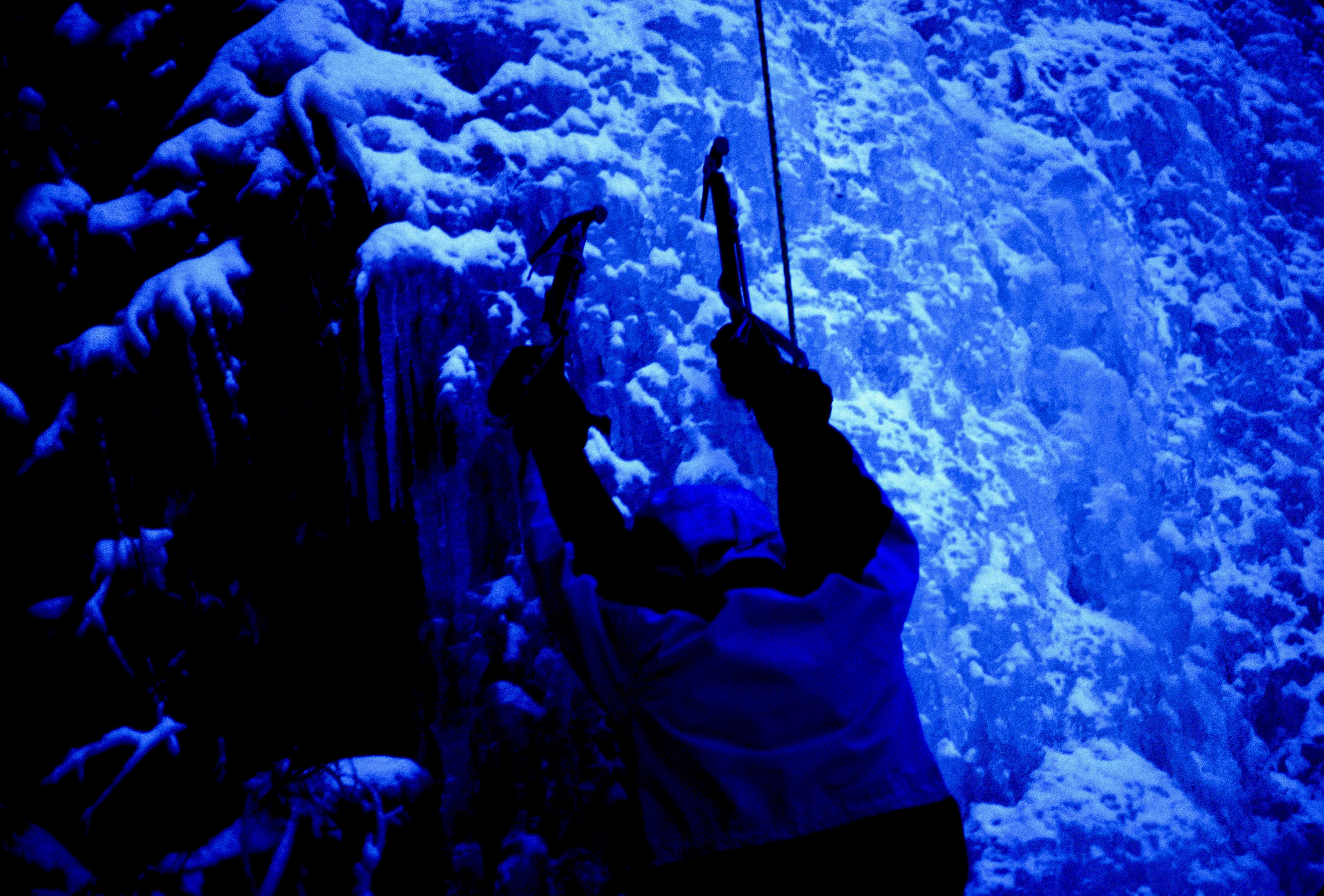
We continued up, crossing a couple of rock bands where we had to take our crampons off, then back on for more ice.

Scan-130224-0020
Another ice section…

I was wishing we had brought some pickets and screws for the ice, but we had left all the snow protection at home.

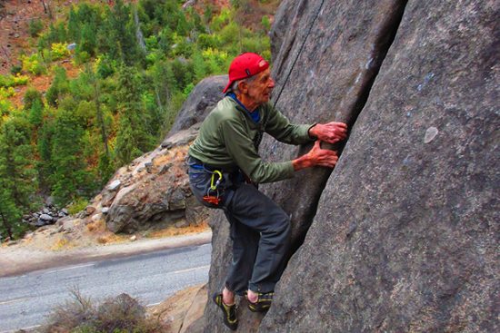
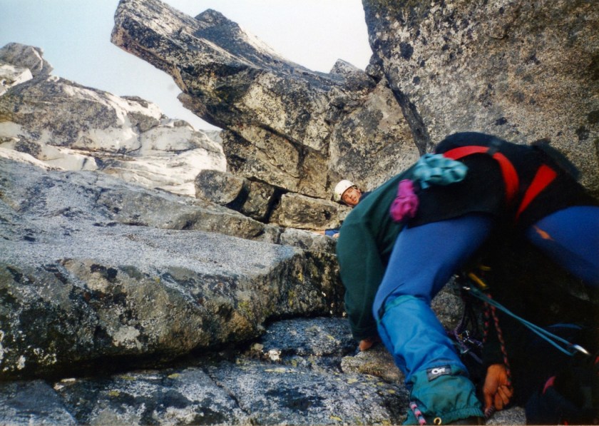
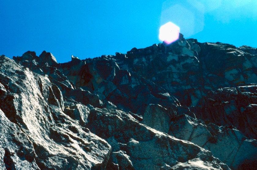
We got off the ice and started climbing class 3 rock, across loose blocks and gritty ledges.  This whole area has many possible ways to go, but many of them are dead ends that lead nowhere.

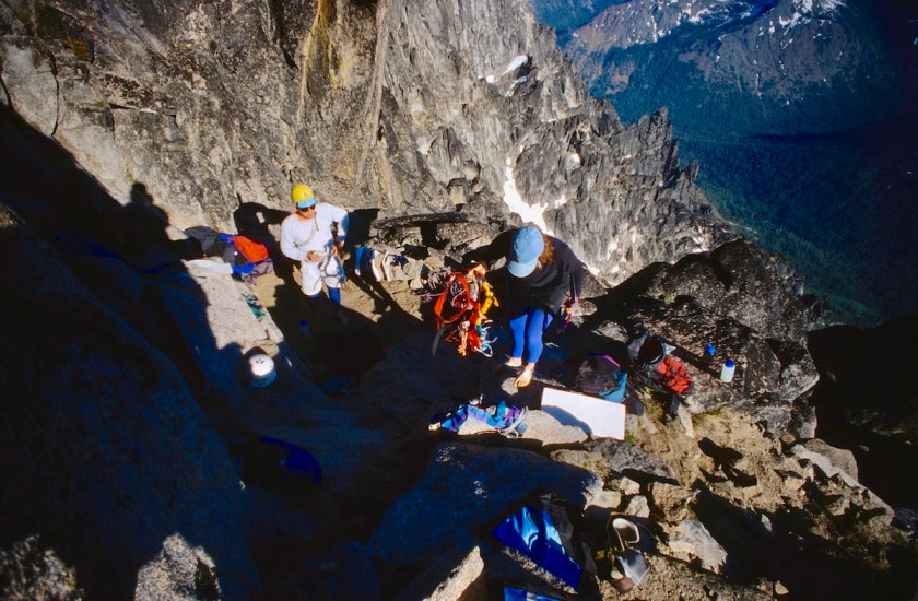
We traversed to the next gully over to the east and moved to the system under Long Johns Tower (8,700 ft.).

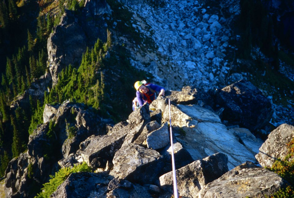
This area was very iced up and wet.  I decided to drop my pack and lead it in my boots so that I could belay the others up.  It had some moves that were difficult in hiking boots on wet, icy slabs.

img541
Me getting ready to lead a corner pitch
img540
Nicole belaying me as I continue up

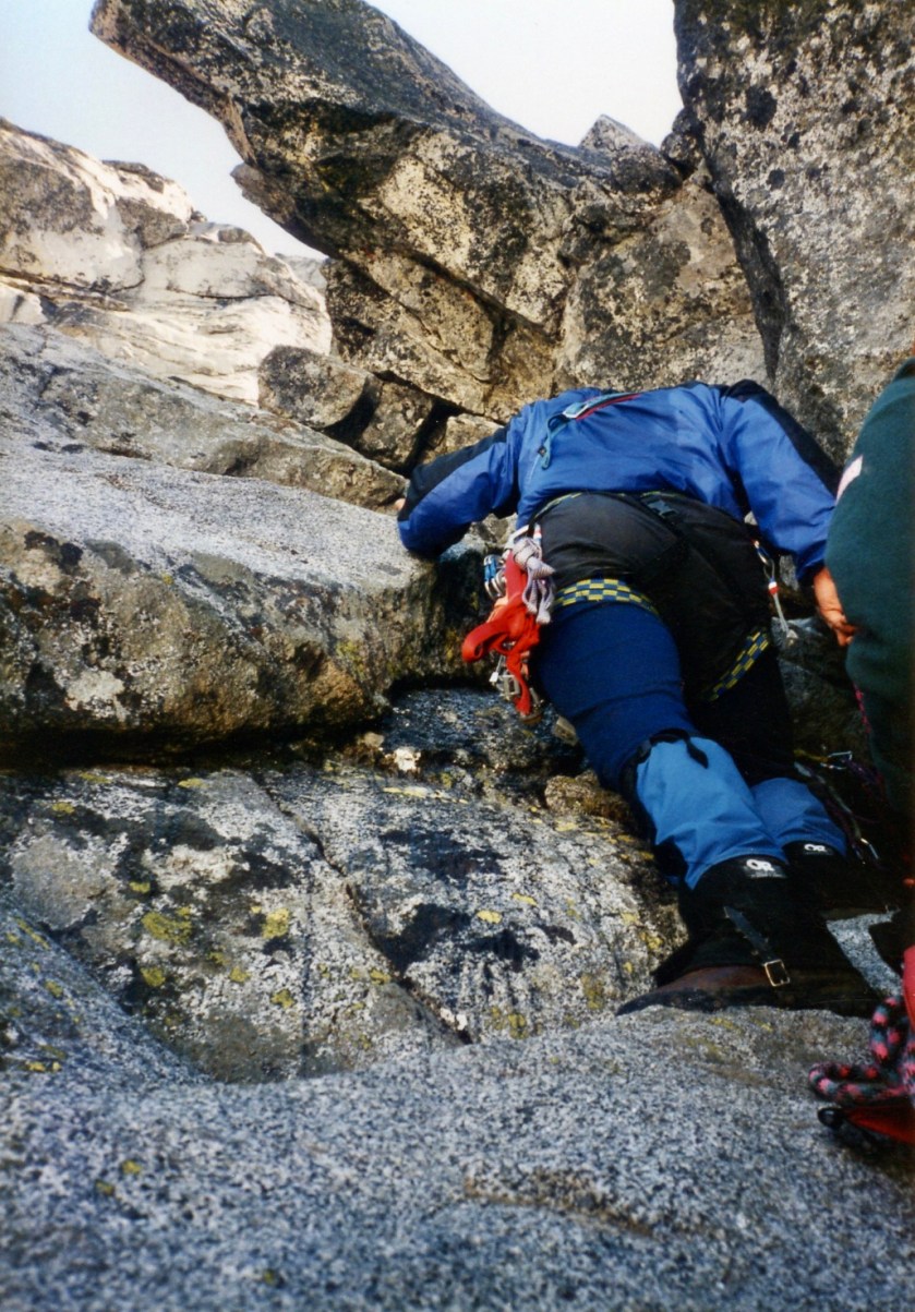
Some of the moves were fairly run-out between protection, including moving out onto the face when the crack system began to overhang. This would have been pure pleasure on dry granite, but the theme of this climb was turning out to be wet, icy and slippery.

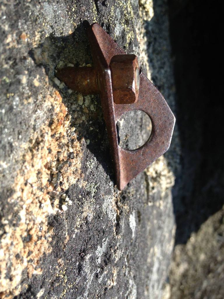
The chimney to the right looked easier, but it was full of snow and I couldn’t see a way to get into it.  I reached a point where I didn’t see anywhere else to go, but found an old rusty piton someone had pounded in a long time ago.

I thought that was good enough for now and picked up a chunk of rock and pounded it in a little more solid, clipped it, placed a stopper and slung another big block for a belay.

I then brought Rick up (he wore his pack climbing up) using a little tight-rope hoisting action, to about halfway up the pitch and then he hauled the others packs to a ledge there.

Scan-130220-0006
Rick hanging on for a powerboat break

This was necessary because I couldn’t see the others and there was an overhang the packs might get stuck under.

Stewart 3
Me belaying the others up a pitch

Rick clipped the packs off to a cam and came up, cleaning the rest of the route of gear.  Nicole came up to the belay and then Tom moved up to where the packs were.  We then hauled the packs to the belay and Tom then came up. This extra work from the snow and ice was taking a toll on time.

By now everyone was looking around wondering where the hell we were going from here.  I had been checking out a potential route while I was belaying and they all looked fairly grim.

Scan-130220-0010
The route is somewhere up there…

To the left was a blank slab, with no cracks for placing pro, leading to an overhanging roof.  Directly overhead was a thin finger-tips crack that looked like it might go at 5.12.

What I was hoping would pan out was a move around the arête to the right that traversed under a huge loose-looking block that looked like if the wind blew too hard it would smash me to bits.

It looked like the best bet so I put my rock shoes on and headed out that way into who knew what.

I managed to avoid using the block for a hold and slowly worked my way up some loose chunks to a left slanting crack.  Of course there was no place for any pro up to this point and everyone was getting pretty nervous down below (not as nervous as me!).

I had to make a pretty exposed move with no pro in, but I eventually got a piece in and made a few more nice moves to get to easier ground up higher. Again, the rock on Stuart is very clean granite compared to much of the funky, moss covered rock in the cascades but we were still a bit early on this route even in July it seemed.

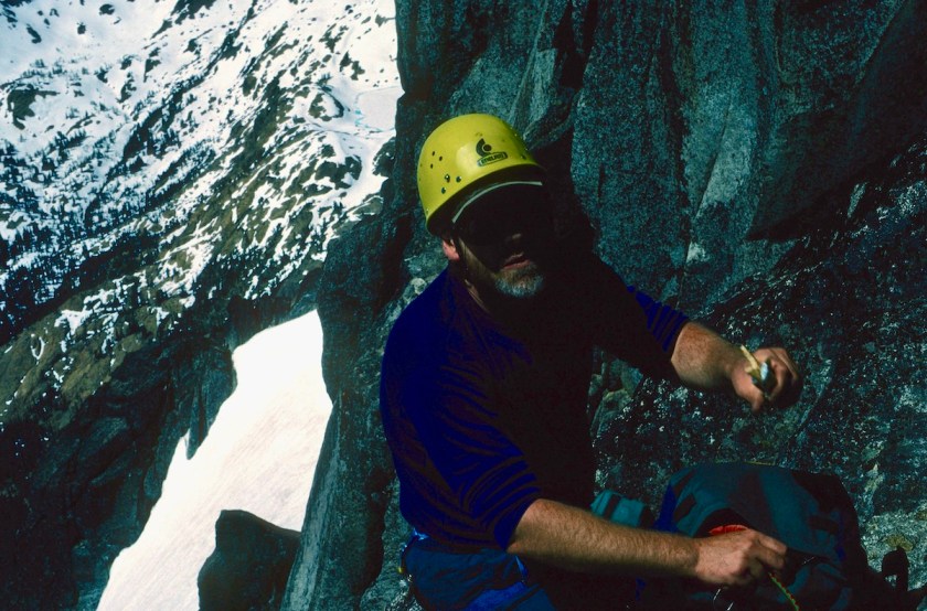
I scrambled up to a nice ledge and set up a belay.  We hauled packs up to that anchor and took a break and had some food.

Water was a real problem all the way up.  All of us would take a drink and then top our bottles off with snow.  I was sucking on chunks of ice and I could tell I was still getting dehydrated.

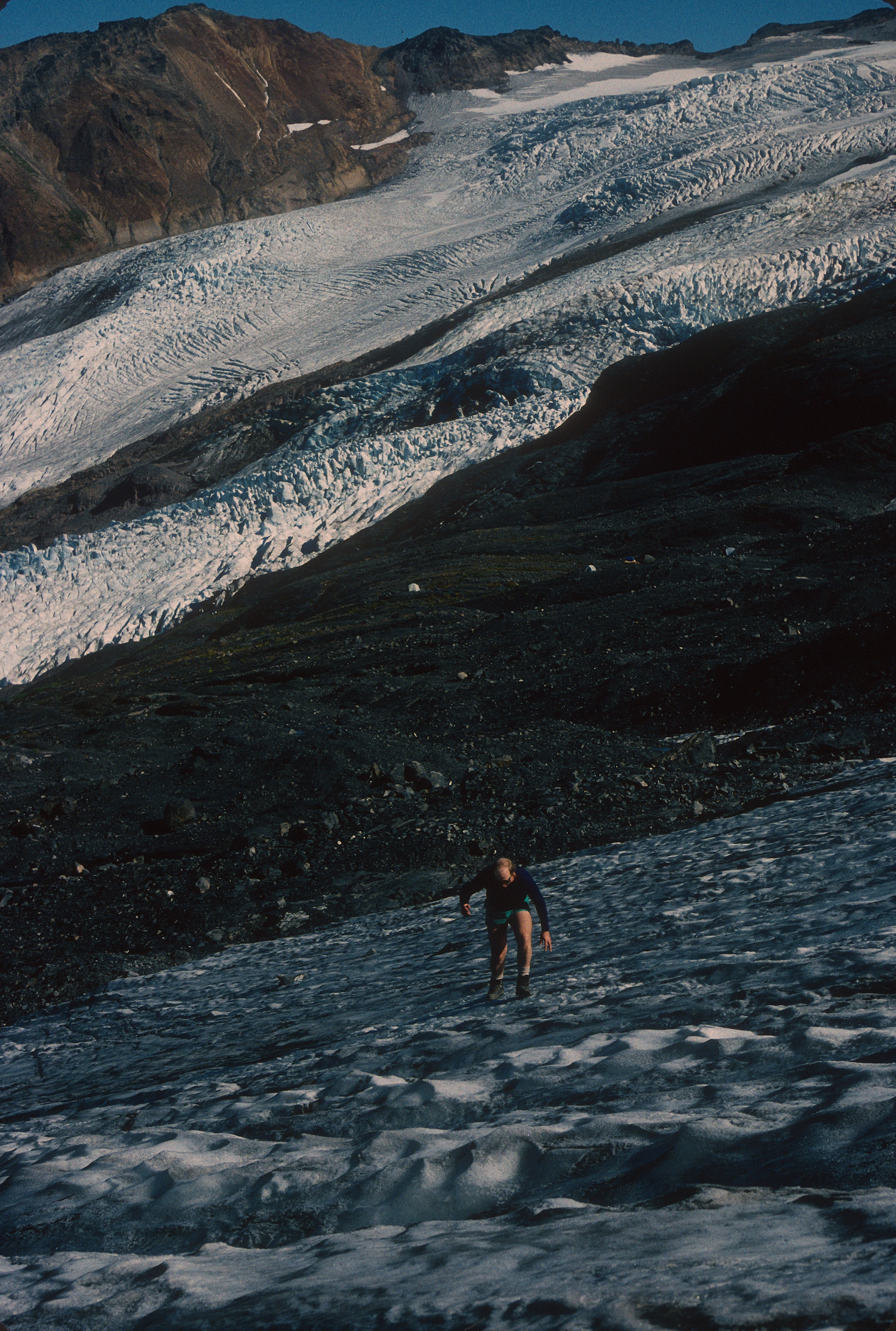
By now the sun was on us and it was hot with the reflector-oven action of the snow.  Directly above the rock pitches was another steep ice chute, so the crampons went back on again.  That section was another calf burner.

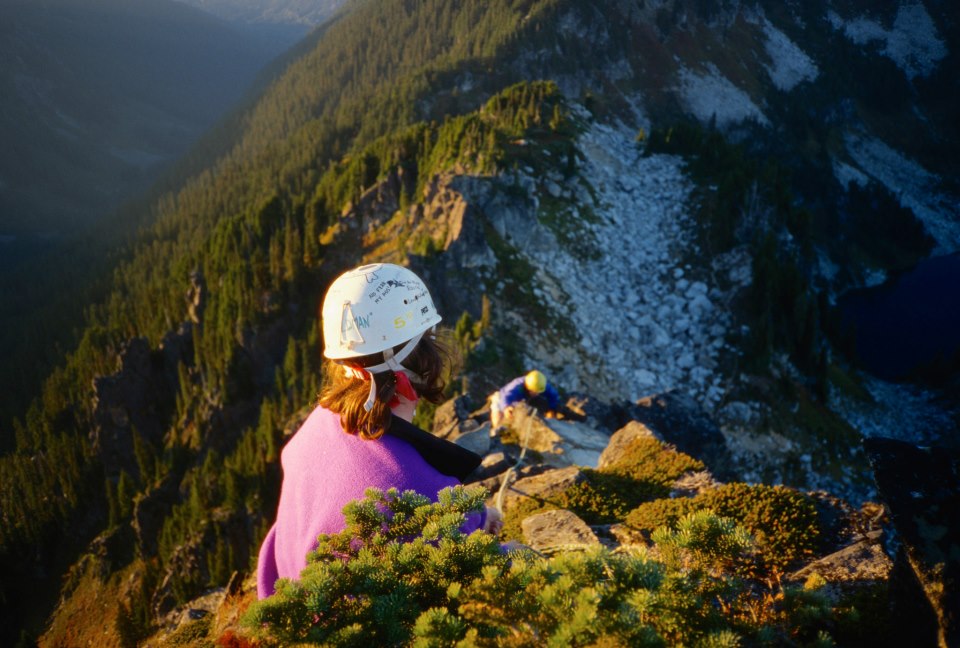
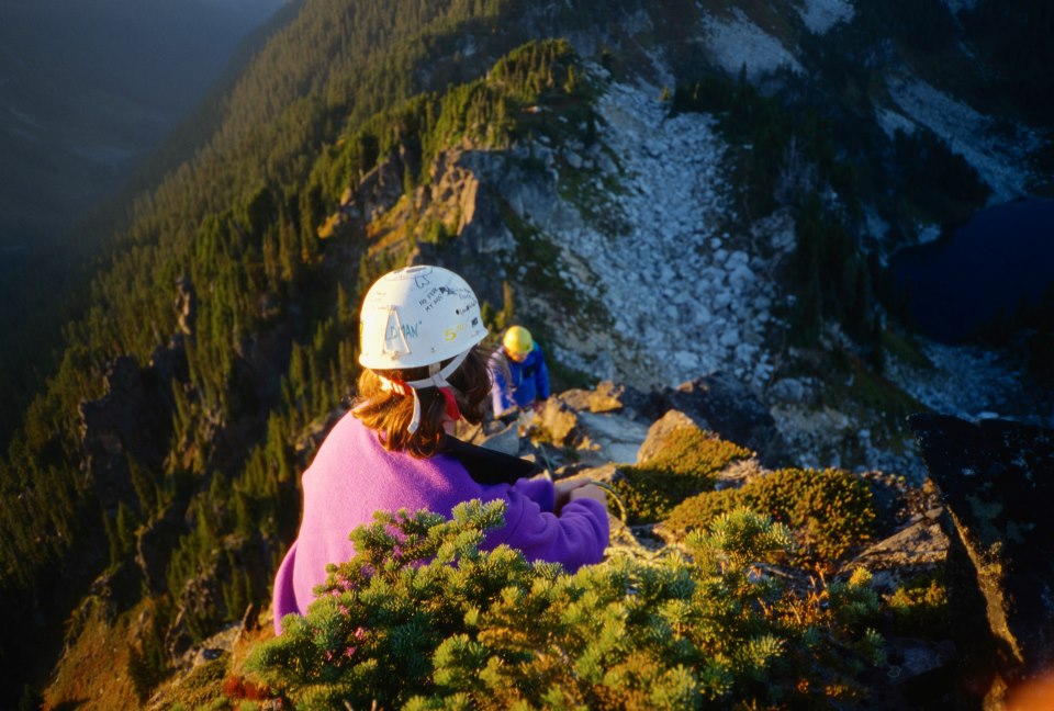
The team caught their breath while I scouted where the route went from there.  There was supposed to be a couple of ways to move up, but it all looked snow covered and grim again.

Scan-130220-0014
Where’s the best line?

While we were climbing the rock pitches, a group down below us had tried another way up and ended up having to rappel down after moving up several pitches into a dead end.  We never saw them again, they must have bailed after that.

I moved us up to try the West Horn route, where there is supposed to be “a broad ledge 200 feet below the summit of the horn (9,100’) under a “scissor like formation”.  I could see what I thought was the right formation, but the ledge looked like it disappeared for 20 or 30 feet.

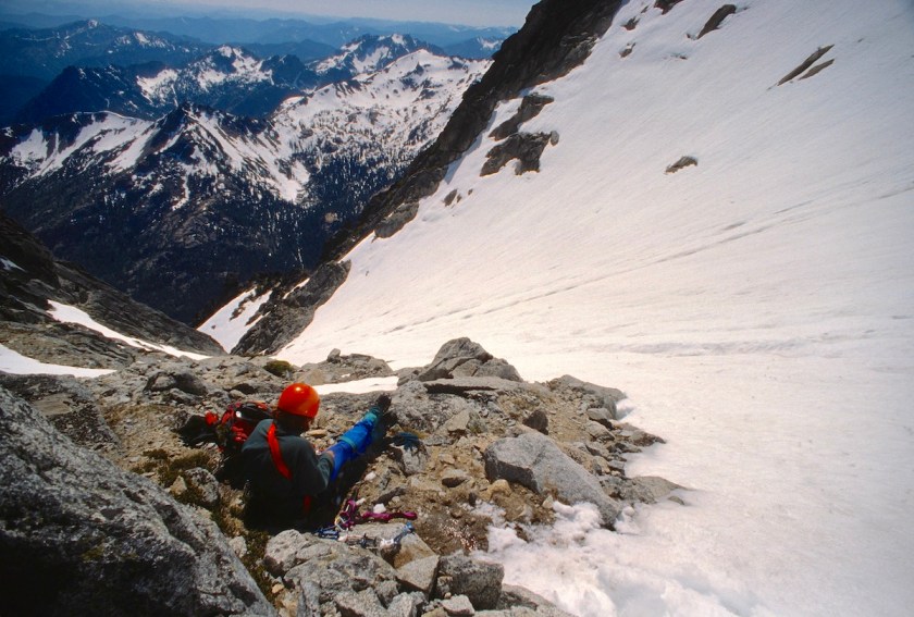
By now it was 5:30 and it was obvious that if we did make the summit we would be down-climbing in the dark.  We were very tired, hungry, and dehydrated.

Nicole wanted to go on, but I think it was only because she had no idea of the work involved in getting off the mountain in the dark and wanted to get back to camp.

Stewart 5
Nicole wondering what she has gotten herself into

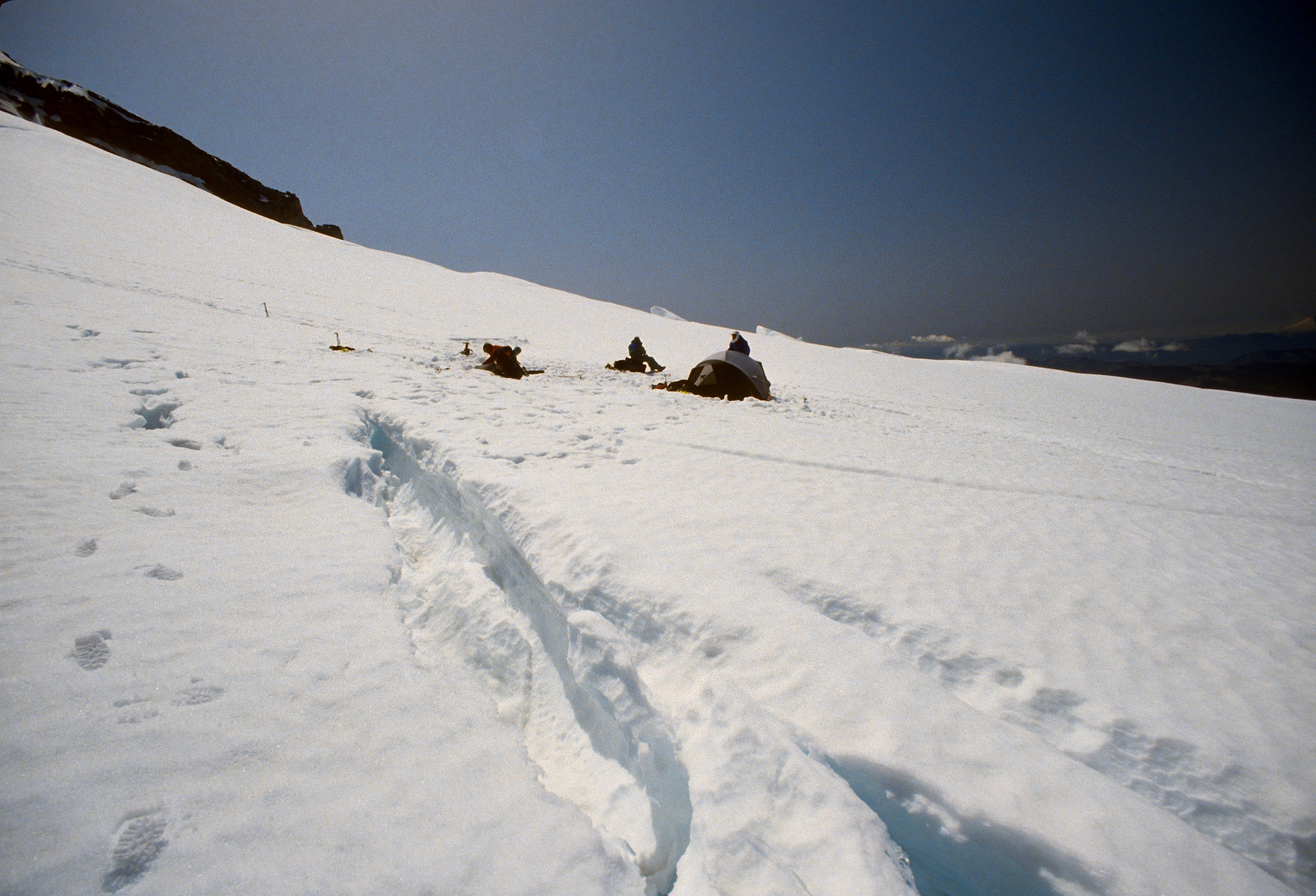
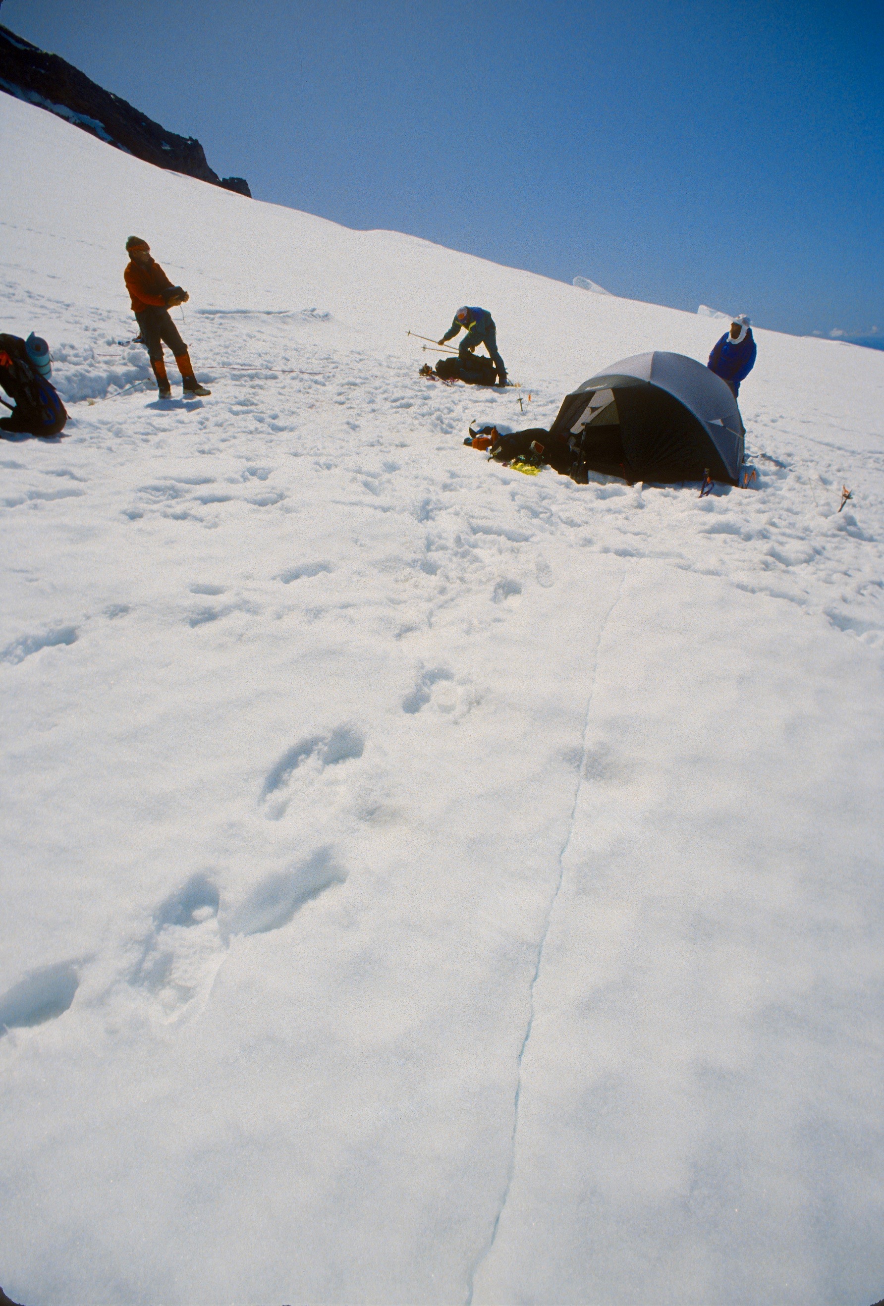
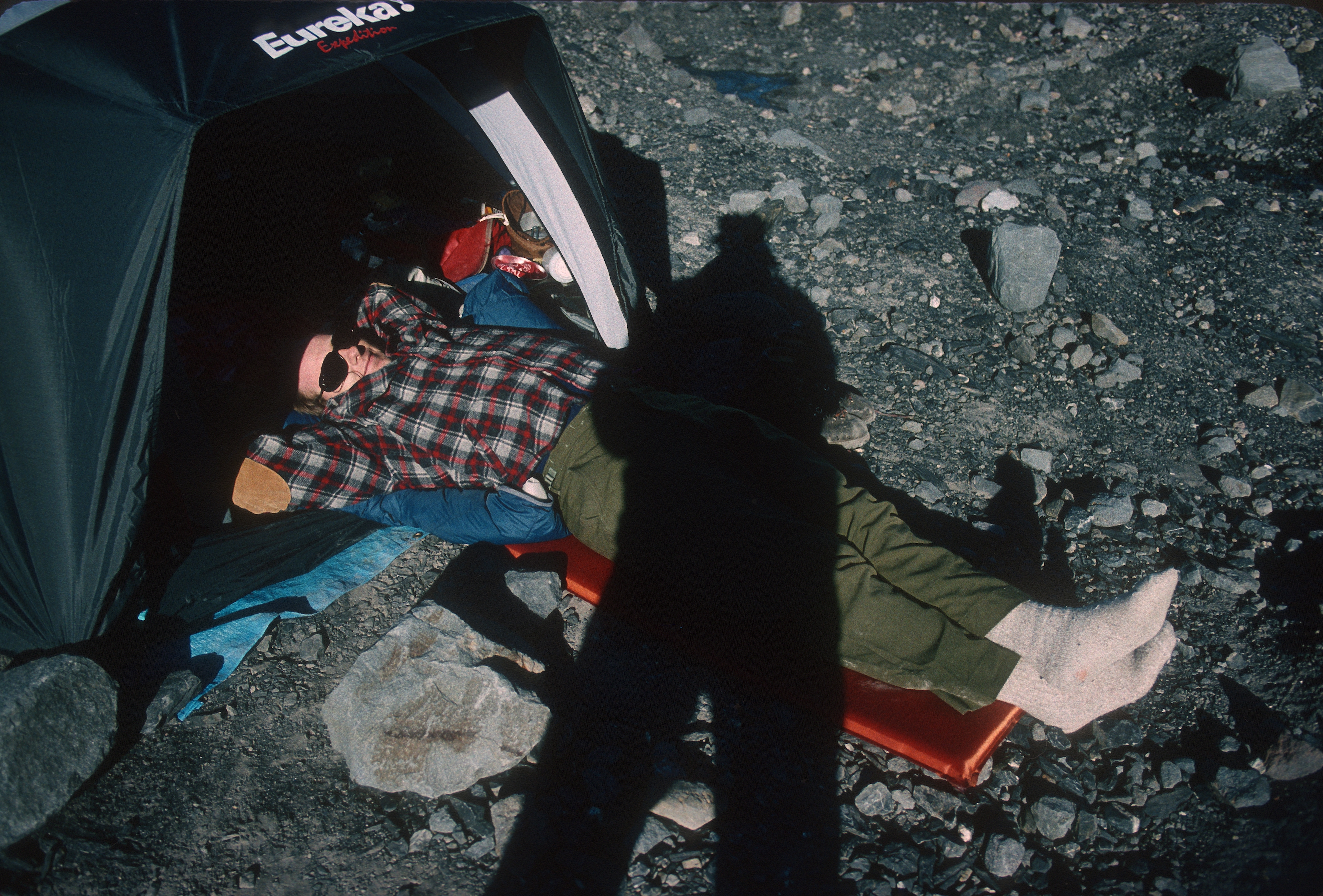
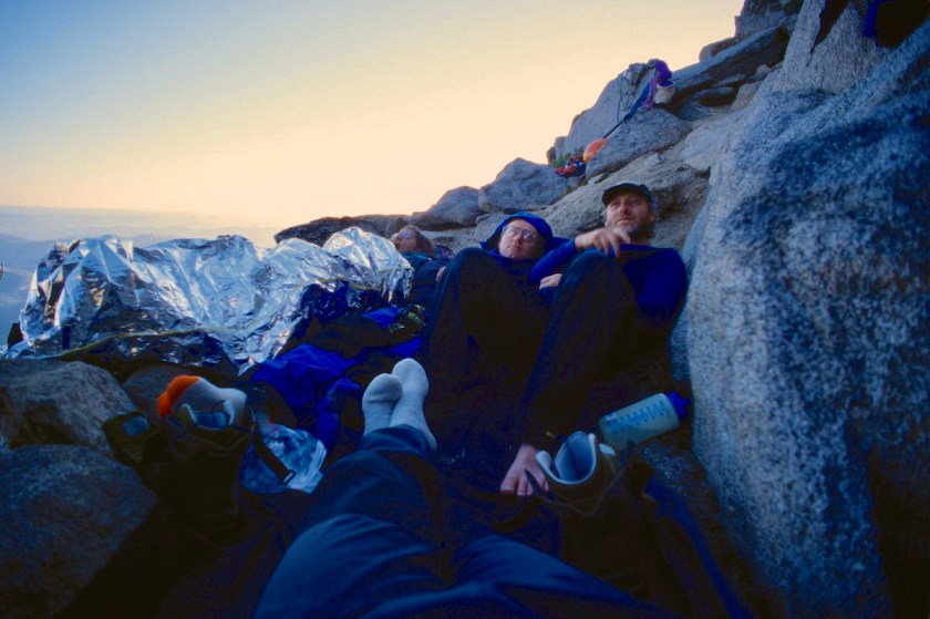
The vote was to do a bivy so that we could dry out our boots and socks before the sun went down, get some water and rest for the push in the morning.

Scan-130224-0025
Soggy boots and socks drying out

I could tell Nicole was nervous about bivying that high on a steep mountain on a small perch.  This was her first time bivying and we had no tents, sleeping bags, stove, etc.

Scan-130224-0022
A tight little perch to spend the night on

Tom had carried his bivy sack as the designated safety bag in case someone got hurt, and he claimed it to sleep in.

Nicole had one of those thin foil-like rescue blanket things, we called it the pop-tart bag.  Rick and I had Hefty trash bags and our packs pulled up around our legs.

Scan-130224-0024
Steep walls and beauty all around

We all had our rain gear and pile jackets.  We dug out a spot barely big enough to cram 4 people onto with our ice axes and stacked a rock wall on one side to keep us from rolling over the edge.

Scan-130224-0027
Snug as a bunch of snaffle hounds in a rug

Rick found a drip from a chunk of ice and we slowly filled our water bottles.  We ate what munchy food we had left (candy bars, cheese sticks, etc.) and started drying our clothing out.

Scan-130224-0023
Rick sniffing out some water trickles to fill up bottles

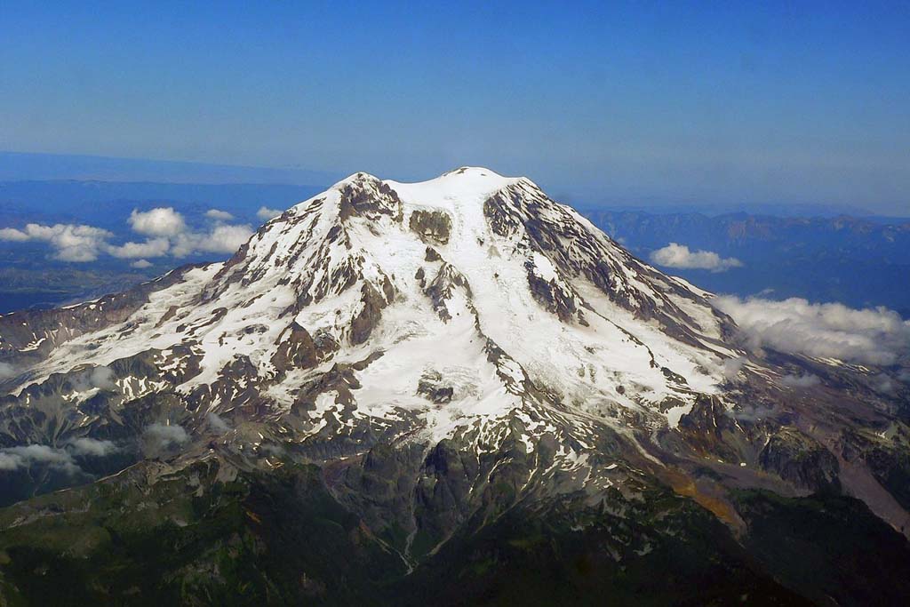
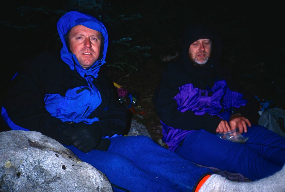
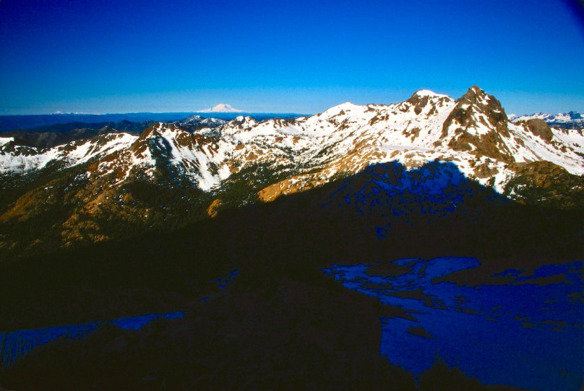
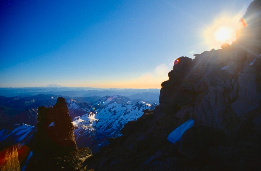
As the sun went down it got colder and soon we were all hunkered together in our Gore-Tex and makeshift bivy gear watching the light over on Rainier and Adams. In the summer the sun stays up well past 9:00 PM at this latitude.

Scan-130224-0028
The crew acting like they are asleep for a pic.
Scan-130224-0029
No academy awards for this bunch

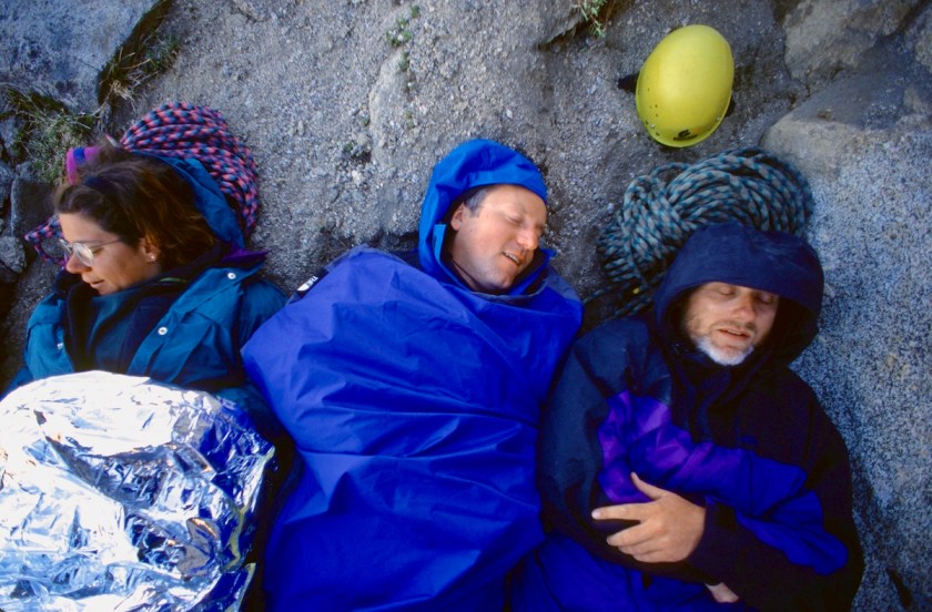
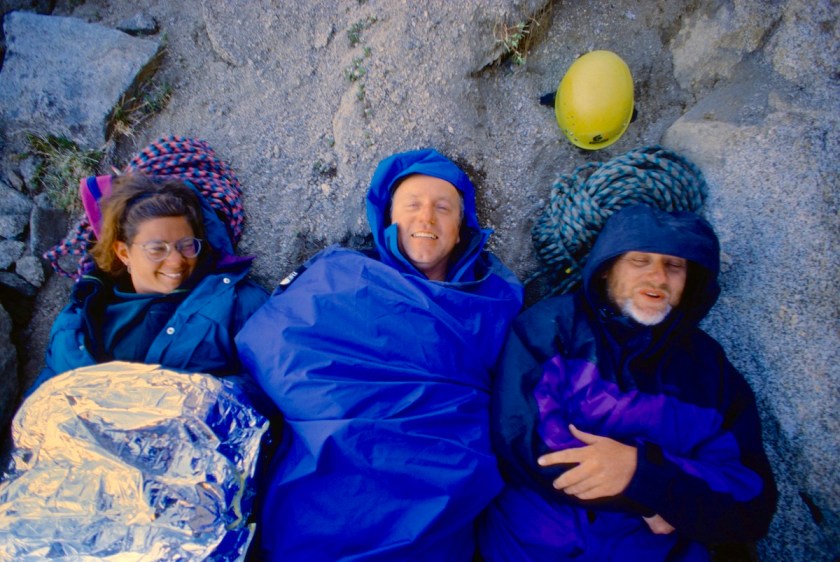
The night was uncomfortable but not totally hideous.  The stars were actually beautiful in the clear air that high up.  Everyone was stiff from the cold and all the climbing.  Rick stuffed his ears with toilet paper to muffle Tom’s snoring.

Scan-130224-0026
The sun heading down to the west

I figured I wouldn’t sleep much anyway and didn’t bother.  Of course Tom and I had good sport with the fact that there were two warm sleeping bags down at base camp all alone.

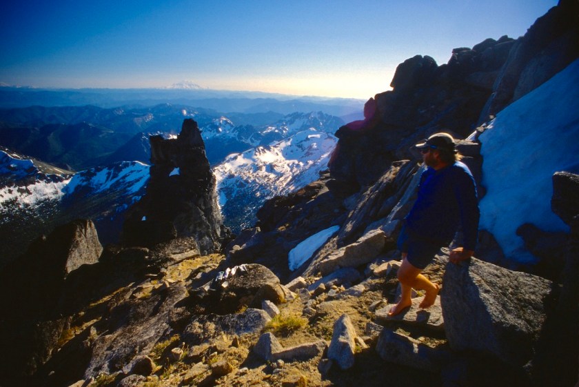
We watched the sun rise from high on our perch and started moving about to get warmed up and shake out the stiffness.  We collected our gear and got suited up for the days activities.

I was looking around for a possible route and for a way to get up to the so-called “broad ledge” that was supposed to be there.

I found a way that led back up to the crest of the ridge and we followed it for a while, traversing east and moving up and down as the rock dictated.

We dropped down a bit and traversed over into the next gully system and I found a way to get up to the ledge that had looked so ominous the day before.  It started out not too bad.  A couple of short moves and we were on a fairly broad ledge, although it had tremendous exposure.

It dropped straight down for over a thousand feet to the gully below.  Traversing along the ledge I got to the part where it looked bad from below.  It now looked worse than bad up close.

The ledge shrank to almost nothing for about 15 feet.  Then there was a gap of about 5 feet where there was no ledge at all, and you had to step across nothing to a big loose block on the other side that rocked when you got on it.

This would have been just a quick scamper if it was at sea level, but up here with the exposure it was rather intimidating.

When you looked between your legs or at your foot placements you could see down for what seemed like for-fucking-ever.  Scary, but very cool and Alpine!

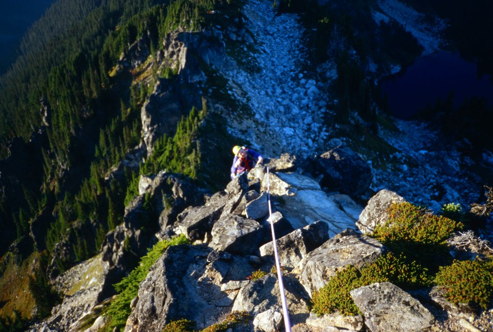
I dropped my pack and put on rock shoes to lead across it and put up a rope to belay the others up.

Scan-130225-0002
Tom starting across the missing ledge section
Scan-130225-0001
He’s across the hairy exposure bit…
Scan-130225-0003
…and now has to climb over the loose block that rocks back and forth

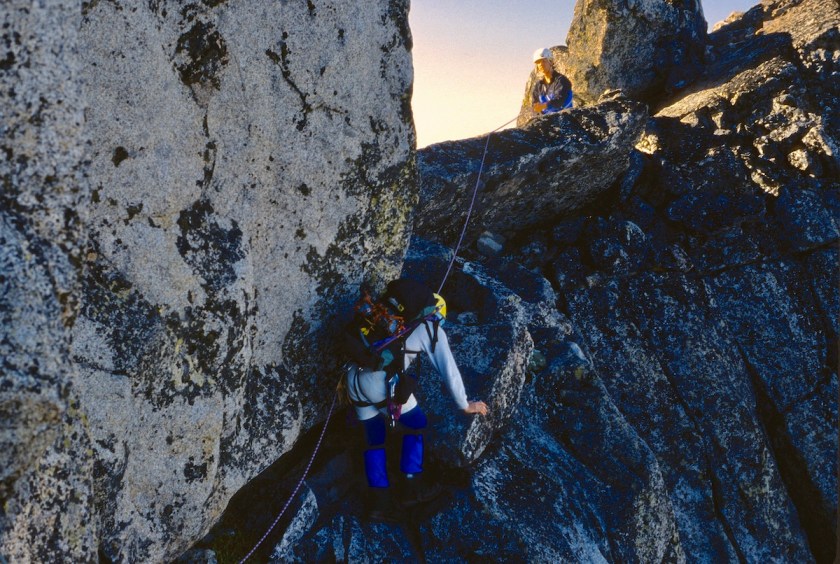
Rick volunteered to go last, knowing that meant that the piece of pro I put in the middle would be gone and the if he fell there was the possibility of a smashing pendulum into the other side that might dent his ass like the fall he took on Knife in the Toaster, but that’s another story.

We hauled packs across and Rick made it just fine.  Broad ledge indeed.

I then looked across to the next section and decided we needed to down climb a bit across an interesting system of ledges.  This was again tricky route finding.

We came to several dead ends and had to back track for short sections, moving either up or down to the next ledge.  We came to a fairly steep ice section that we had to traverse.

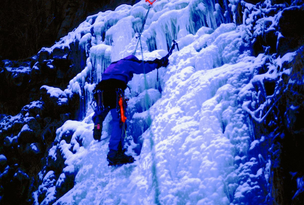
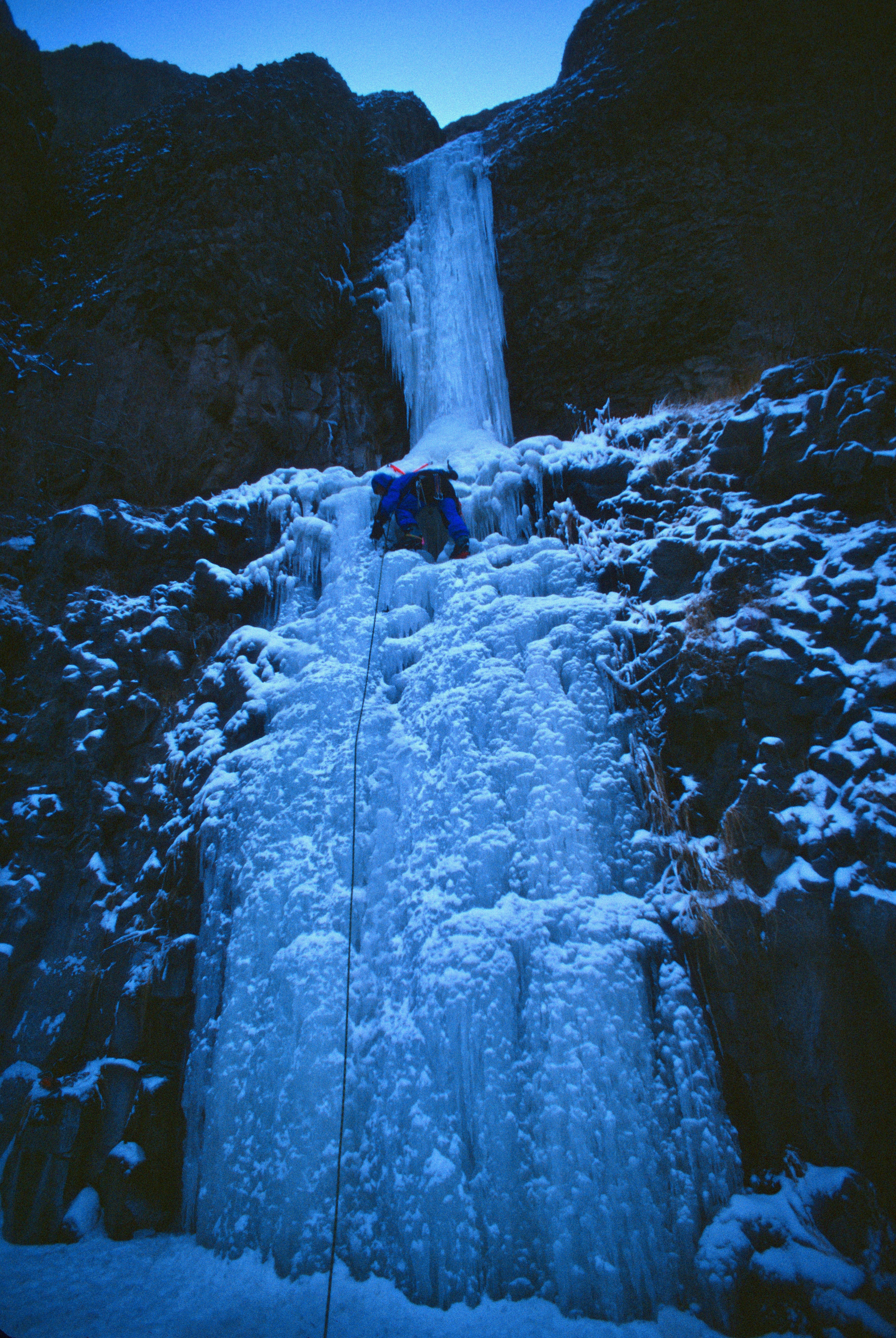
The run-out was again all the way down the mountain so slipping was out of the question.  Solid crampon placements and good ice ax belays were needed here.

It moved across a very steep section to a corner where it eased a bit.  Then you had to down climb about 50 feet of very steep ice to a blocky ledge.  I tried to kick pigeon holes as deep as I could for the others to follow.

Scan-130220-0017
Down climbing a steep bit of ice.

Nicole thought this was the most intimidating section of the trip.  It was kind of scary thinking about falling there.

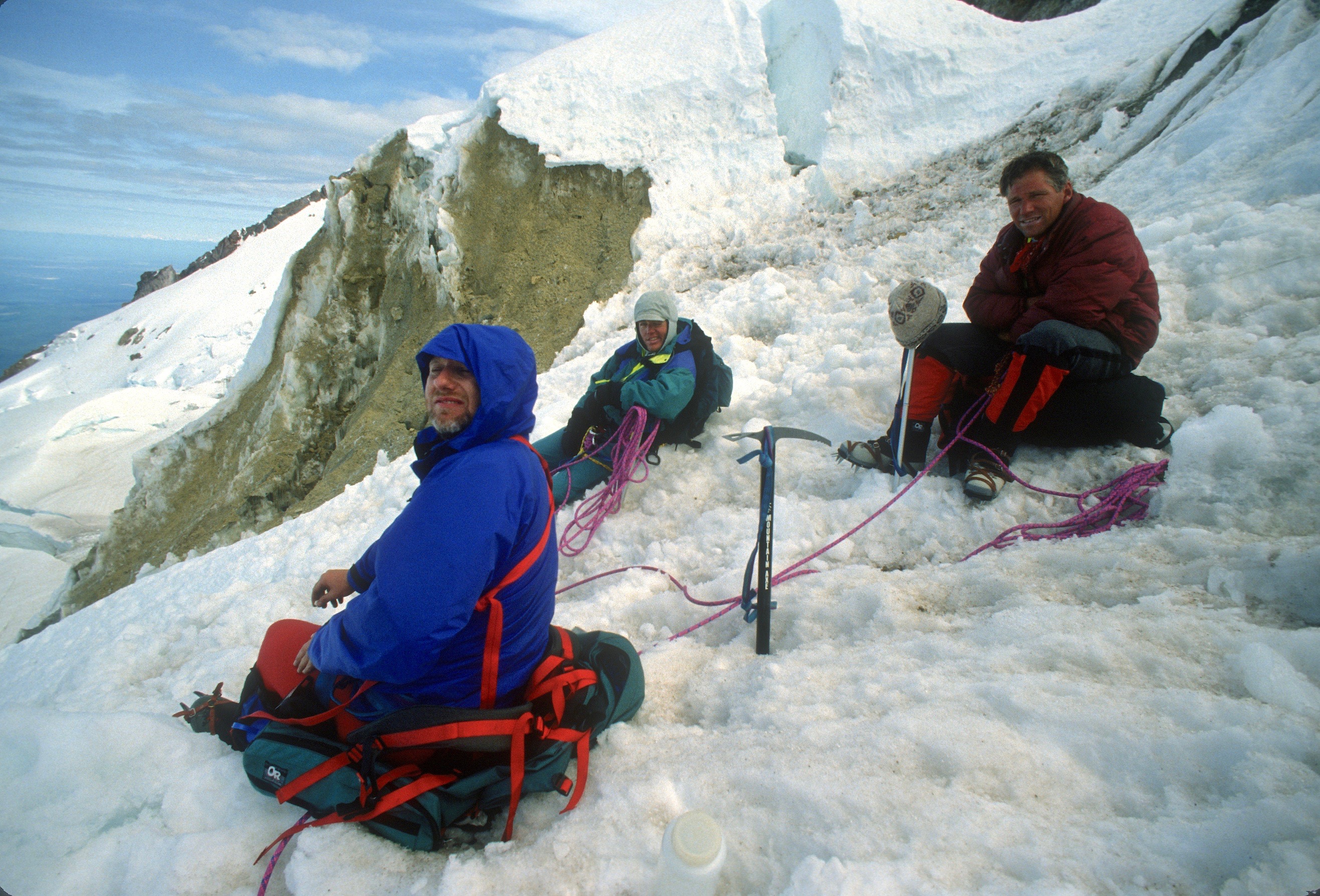
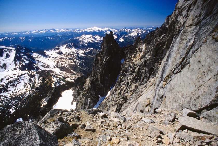
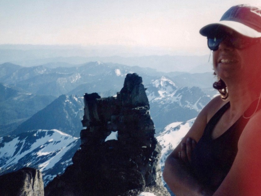
Eventually we moved our way up and around to the west ridge notch, a deep cleft that marks the base of the final summit block.  On the north side it drops off so fast it makes your head swim from just looking that direction.

The south side offers a bit of a help, but it quickly went no where.  I saw a big ledge down below about 200 feet, so we again put on crampons and descended a steep gully to the ledge.

Scan-130225-0006
Steeper than it looks…

Everybody else took a break while I scouted the ledge.  I down climbed for several hundred feet only to find the ledge dead ended at a nasty looking drop.  I climbed back up and told them we needed to climb back up the gully and find a different route.  Grumble, grumble.

We searched high and low and decided to start rock climbing a pitch that didn’t look too awful.  We got up to a ledge that went to the north and south.  I followed it both ways looking for a route but nothing looked obvious.

The north side was covered with a big patch of crusty snow and got real steep.  The west face was also steep and slightly overhung, while the south side was sunny, but long and steep with a wild system of cracks with snow all over it.

We went to the south and scoured the rock for a possible route.  Nothing seemed to look like it was under 5.9, and there was supposed to be a 5.6 route.  Back to the North side for another look.

The snow looked too dangerous to try moving through it on such a steep face.  Back to the south side and a descent down a loose funky ledge to nothing.  Back up to the ledge and a team meeting about the possibilities.

We were only about 150 feet from the summit.  A single rope length. We could see people looking over the edge and could hear them talking.  They had gone up the much easier Cascadian Couloir, the standard route which is simply a walk up, comparatively.  That was the easy gully route we had planned to descend.

The thought of going back down anything like we came up was extremely uncomforting.  The snow was getting soft and balling up under crampons.

One of the issues was that there was a solid layer of ice a few inches under the soft snow on top, making every step on the steep snow totally unpredictable and prone to blowing out.

Everyone was tired, water was still scarce so everyone was again dehydrated.  We were all out of any substantial food.  We did have a little bit of “emergency” food like power bars and such.  Looking down the steep drop off in the gully, we reluctantly decided to bail. Strike 2 on Stuart.

We began by down climbing the rock we had climbed up.  This took us to the top of the West Ridge Couloir.  Looking down this steep chute I knew we had an epic decent in store for us.  At first we could use our crampons, but the snow quickly turned bad as it thawed out more.

Scan-130225-0004
Up and down, up and down…
Scan-130225-0005
Now committed to down…

The first few inches was mush while the base was hard ice.  The angle was steep enough that if you tried plunge stepping the heel would dig in just until it hit the ice and then slide along the crust.

This made descending very tedious.  We had to turn around and face into the slope and kick foot holes, known as “pigeon holes”.

These toe holes also served as hand holds as you climbed down past them.  One hand on an ice ax and one hand in a pigeon hole.  This made for cold hands and is extremely tiring on the calves.

Scan-130225-0007
The sun is turning the snow to mush on top, clogging up the crampons. We eventually had to take them off.

Rick was unsure of using his ax in the dagger position and so he used the slower self belay technique where the shaft is shoved down into the snow with each step.  This is also more taxing on the arms.

We proceeded in this fashion for hours, taking small breaks on the steep ice and on little outcrops of rock when we could.

Scan-130225-0008
Nik taking a short breather before heading back out the snow gully

We began rappelling whenever we could find a half decent anchor to put a sling around.  This would give us 200 feet at a time pretty quickly, although we had to move one at a time.

We rapped so many times that I can’t remember the exact number.  Rappelling and pigeon holing, we made our way to where the gully pinched shut to a waterfall.

This was great at first because we had all the water we could swallow.  We sucked it up like camels after crossing the Sahara.

The next problem was finding a way to rap past the falls without getting soaking wet.  I led a traverse pitch off to the left and found a couple of loose blocks that were big enough to hold our weight.

We rapped again and down climbed to a short chimney and down to another steep area with another waterfall off to the right.  The ropes were by now sopping wet and weighed 3 or 4 times what they had started at.  As you rapped down your rappel device wrung ice water into your lap as the rope passed through.  Just re-coiling the heavy ropes to move down a bit was enough to fry the arm muscles.

We came to a section that was very cliffy, with snow patches.  We rapped and down-climbed through this to a section where the snow underneath us was hollow where the water had formed a cavern along the gully.

Punching through this would put you in deep shit.  You would fall down steep icy rock and be pummeled by ice cold melt water after you got wedged into a bottle neck under the snow.  Not a pretty thought.

So we continued to use the ropes to rappel.  Rick broke through at one point but the ropes saved his ass from falling too far down.  I rapped down yet another section as it was getting dark and moved off to the right to a cliffy area that showed some promise of getting us off the snow and out of the gully.

I hoped that we could do a couple of raps down to the talus field and pick our way through the moraine to the way trail.  I scouted a spot to rap and went back to wait for the others to catch up.

When we were back together Tom told me that he thought I should look at my rope.  Rick had dislodged a big rock and it had nicked the rope up pretty good. Captain avalanche had struck again.

I looked at it closer and the sheath had been completely cut through almost all the way around the rope along with a number of the weight-bearing strands.  This truly sucked.  Now we couldn’t make full rope-length rappels.

It was by now about 10:30 Sunday night and was pretty dark.  The others (who all had real jobs to be at Monday) said they were OK doing another bivy. This was the safest decision, since we were all beat and had eaten very little food all day.

We carried on a bit, down to a fairly level spot for three of us while Rick had his own little spot.  It was warmer than the previous nights, but this brought its own problems.

Much lower in altitude and thus warmer, mosquitoes now plagued us all night.  I cinched up my hood to a small opening and they still made their evil way in to assault me. Rick’s face got pretty chewed up. Tom and Nichole could stick their heads down in their bivy sacks for some relief.

The night seemed to take forever with the bugs sucking our faces and hands dry, with us thinking about all the food, clothing and sleeping bags that had now been down at base camp unattended for three days.

Dawn finally broke and we stiffly got moving and started pulling on boots and packing up.

Scan-130225-0009
It was too dark to get any pics the night before, but here is bivy #2 in the morning
Scan-130225-0010
There is a drop of several hundred feet on the other side of that tree
Scan-130225-0011
Tom looking over what we didn’t want to go down in the dark

We then headed back into the gully for more snow and hollow ice bridges.  Eventually we made it back down into trees and greenery after being up in snow and bare granite for so long.

We continued down to the stream and crossed it.  We never found the way trail that was supposed to be there, so I led off cross-country back to our base camp.

This was a hoot also, the mountain was going to fuck with us all the way out.  Crossing swollen creeks, devils club and alder thickets we made it back to our base camp.

We collapsed on our sleeping pads and proceeded to have a food orgy.  We were eating all kinds of shit, cooking and drinking water for a couple of hours.

We slowly packed our remaining gear and now had heavier packs to hump back up to the pass.  We moved cross-country again up towards the trail at Ingall’s pass.

There was plenty of soft snow to slog through and it was getting plenty hot in the big open bowl.  Slog, slog, slog.  Sweat, sweat, sweat.

Scan-130225-0015
Off the mountain and slogging back up to the pass in soft snow

Scan-130225-0016

Scan-130225-0017

Finally, we were back on an actual trail with solid steps kicked into the snow.  I made it over to Ingall’s Pass before the others and tossed my pack off to wait on them.

Scan-130225-0018
Taking a pic of the mountain from the top of the pass when I heard a chopper…

Sitting there alone, I heard a helicopter over on the other side of the pass and wondered if it could be a rescue flight.  About that time I saw the chopper flying low over the approach trail and thought “oh shit”.

The chopper flew right up and only about 30 feet over me.  I waved and they waved back.  “OK, maybe they are just sight seeing” I thought.

Scan-130225-0020
Look close and you can see a white Bell Jet Ranger looking for us
Scan-130225-0020 copy
Hey fellas!

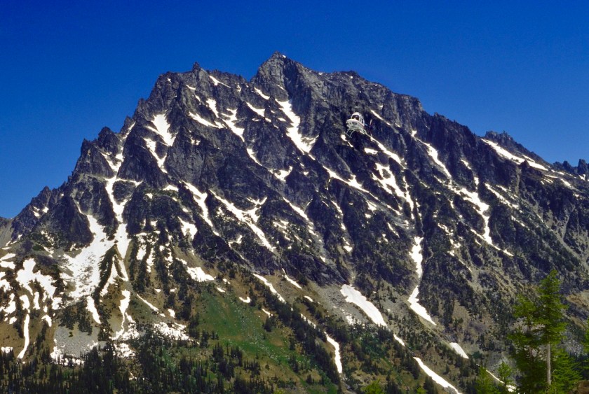
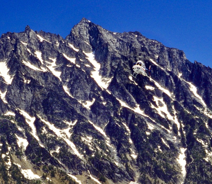
They continued following the tracks in the snow and flew over the rest of our group, heading right over to the West Ridge of Stuart.

As soon as they did that I knew they were looking for us.  The chopper circled back around, by that time the rest of the team had caught up to me on the pass.

The helicopter took another low pass over us and then circled back again.

This time they were coming in much slower and there was an arm holding something out of a window.  As it passed over our heads the arm tossed down a spare blank log book.

I ran over to grab it and just as I got to it, the rotor blast hit it and blew the log book and my hat down the slope about 50 yards.  I climbed down to get my hat and the log book.

Tom found a note that had been inside the log book that read “wave if you are Nicole G”.

Scan-130225-0024 2

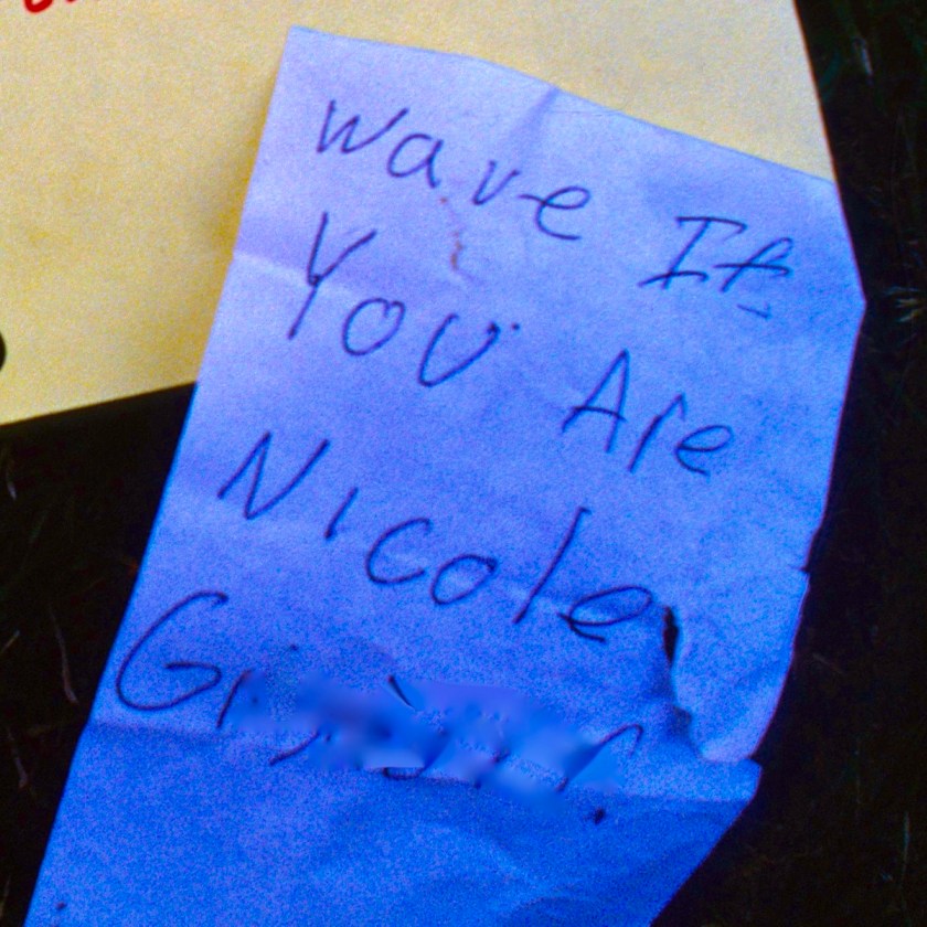
Nicole was immediately shocked to find out that someone she knew had sent a helicopter to find us, but waved back at the chopper and off it went back to wherever it had come from.

Then she was all worried that she would have to pay for the cost of the rescue attempt and all that.  Of course we helped by telling her that she would indeed have to pay and that it would cost around $15,000 or so because aviation fuel and pilots are expensive. We started cracking jokes about all the news teams waiting down at the parking lot to interview her and all that.

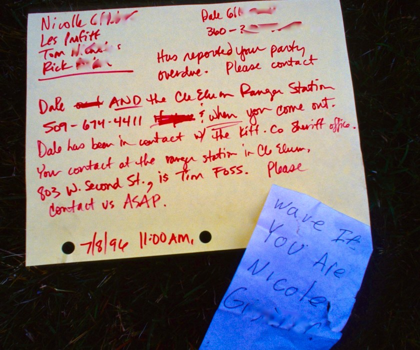
It turns out that Nicole’s dad Dale, who had been recently diagnosed with cancer and given less than 6 months to live, was worried about his daughter and had called the ranger station to report us being a day late.

The ranger stated that they wouldn’t send a helicopter that soon because the weather was good, that we were on a hard route and were probably just behind schedule. This was all well before cell phones were in everyone’s pockets and we were now a day overdue to those that cared back home. Anyone that knew me and Rick would only be mildly concerned, as this was not uncommon for us.

Dale then asked how much it would be if he paid for a chopper to go and check on us.  The ranger told him $600 and Dale told him to go ahead…so the ranger got a free scenic flight over Mt. Stuart. He was still pretty excited about getting a free (to him) helicopter ride when we reported into him over the phone after we got back to civilization.

Scan-130225-0024 3
Message left on our car by the ranger along with Chopper Girl’s note

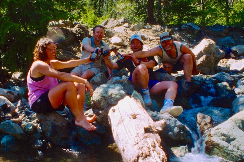
We finished the last few miles down hill in the blast of heat and soaked our feet and washed off in the cold, clear creek that runs by the parking lot.

Scan-130225-0022
The wild bunch cleaning up a bit in the ice water

We sucked down a couple of beers from the car and celebrated our awesome, epic climb.

Scan-130225-0023
Cheers to another classic climb!

We then headed home to explain to all the worried people that we were not lost, just trying to be “safe”… if you can say that with a straight face about the route we had been on.

Altogether a very memorable time and yet another epic “classic” for the books… and Nicole had earned a new climber’s nickname…Chopper Girl.

Scan-130225-0021
The route up follows the longest gully on the left up to the ridge, then traverses along the ridgeline to the summit block. Coming down route follows the bigger gully in the center under the summit block.

screen-shot-2022-01-20-at-4.13.36-pm

Bits and Pieces

I was digging around in my old pics and came by this single shot taken with a cheap disposable camera I had clipped to my harness. It shows Tom rapping off of “Bits & Pieces” back about 1990-something. It was a butt-puckering 2 pitch 5.7 X route. It was notable only because of the X designation, due to it having only 2 bent, rusty 1/4″ bolts for the whole 1st pitch, with likelihood of death or serious injury if you fell and took a grounder.  It is located well off the beaten path on the backside of the most popular climbs at Smith Rock, Oregon.

I led the 1st pitch, clipping the 2 ancient 1/4″ bolts up to a decent size ledge. Unfortunately, there were no anchor bolts or cracks to get any cams or other protection in so I had to bring Tom up without a real anchor.  There were a couple of rocky knobs to brace my feet against… so I told him not to fall. 

Pic I found on the internet of the route today, with several shiny new bolts for pro.

He got up to the ledge and we looked at the next pitch with no bolts, still thinking this was our escape route… we saw no way to get pro in on the loose tufa of Smith Rock on the route above us and saw no other bolts.  Hence the X rating.

We decided to bravely run away…but there being no way to anchor off for the rappel, I had to become the anchor…not the best situation to be in.

Almost to the ledge…

He was super excited to rap down with nothing but me holding him up but we didn’t have any other choice since we didn’t bring my bolt kit.  Tom rappelled off using only me with my feet braced and a “see you at the bottom, one way or another”.

Tom nervously begins rapping off, using me as his only anchor.

I had him clip a sling back in to the top bolt as he passed it (there were only 2 remember?) so I would have at least a bit of psychological protection.  He let out a big sigh of relief when he got to the bottom

The bolt he clipped the sling back into was about 20 feet below the lip so I could down climb with at least the illusion of protection since there was no way for me to rappel down. At least if I fell, and the bolt held, I’d only have a 40-50 foot whipper 

The climb was in a mossy groove in the shade, well worn by water running down the cliff that becomes a waterfall when it rains. Since it got very little traffic due to the danger rating, all of the little pebbles and knobs used for holds are subject to freezing and thawing and popping loose over time.  

The  upper section of the cliff was very vertical, so I couldn’t see the footholds below me at all as I slowly backed and eased over the edge… Tom had to talk me to the knob holds, as I used my feet them to feel all over the cliff to find a big enough pebble to hold my weight. Once I had both feet on something, I could look down and plan my next moves.

To the uninitiated, down climbing is much more difficult than climbing up. Often it is hard to see footholds and you have to resist the natural urge to press yourself into the rock and lean back to see better.

Slowly inching my way down, Tom still offering advice from below, I made my way to the sling. That 20 feet of loose, mossy pebbles with a single manky bolt from when the climb was established in 1977 switched me into Wildman mode… smooshing my feet through the soles of my climbing shoes and onto the holds to make them stick to the rock.

I can’t honestly remember if I left the upper sling in place and continued down climbing or, being a cheap dirt bag climber, snagged my gear and just free climbed the rest of the way down with a puckered butt hole. Probably the latter…I hated leaving gear behind.

Having had so much fun with Bits and Pieces, Tom and I decided to conspire to have our buddy Jim lead the climb next time we were there, but alas, it never happened.

Looking at photos of the climb these days, it has been re-bolted with nice fat modern bolts and proper anchors at the top to rap down, making it a much tamer, relatively easy sport climb. Part of me is sad because it was one of our scary “classics” we always seemed to get ourselves into, but it would make it a nice, shady climb for folks trying to get away from the crowded cliffs at the main part of Smith. Time moves on, and those old bolts only grew more dangerous every year.

Rusty old bolt very common in my heyday…

Tahoma Glacier Ghost Story

This is an improbable story from a summit climb of Mt. Rainier in 1992.  I will start off with the fact that I don’t particularly believe in ghosts, but something wildly peculiar happened high on that mountain that I have no logical explanation for.  With this account, I will focus on this mysterious side story and leave the tale of the epic climb for another time, as it is my favorite route of all the paths I have stumbled up Mt. Rainier on.  First, I will set the stage with what occurred on our climb in 1992, then I will follow it up with a news account of what actually happened along our climbing route back in 1946.

——————————————————————————–

We started our hike in to high camp on Westside road in Mt Rainier National Park by parking at the road closure gate. This road is notorious for being eternally closed off due to the mountain streams causing washouts along the way and making it impassible for all but someone on foot.  This makes it one of the longest and most remote ways to get to the top of Rainier, so we had set aside a full five days to make sure we had plenty of time.

I had used this exact starting point when I was in the Army in 1978 to begin my solo hike around Mt Rainier on the Wonderland Trail.  I had a buddy at Ft. Lewis drop me off at the gated road closure, circled the entire mountain and hitch hiked back after almost two weeks alone on the mountain.  It was on that long, lonely trek that I had decided solo adventuring was not really my thing.  While I had enjoyed high adventure along the way, it was tempered by the fact that no one had experienced it with me to share these stories with.

One of the memories I had from that past solo trip was the feeling of being watched or shadowed by something every time a twig snapped or a few pebbles rolled down a slope.  When alone, your mind, at least my mind, after a few run-ins with small critters, deer, and even a bear, very easily wanders to improbable scenarios like it’s a cougar stalking me, or after a few more isolated days, even Sasquatch or Bigfoot playing games.

This trip however, I had my partner in crime of many adventures, Rick, and some friends of his from work that we had been training for a few months to get ready for this remote accent.  We took off quickly with our heavy climbing packs loaded with gear and supplies to last the week we expected to be on the mountain.  We worked our way along the road in the foggy, misty morning, working on the occasional blisters and settling our individual loads.

Blister break along West Side Road

The path I had walked almost 20 years before was still familiar, but altogether different at the same time.  With four men full of testosterone there is much more noise… grunting, laughing and storytelling, so there was much less navel-gazing even as I passed places that I remembered where rocks had rolled down a road cut or bushes moved with an imagined adversary skulking in the shadows.

Our route on the Tahoma Glacier running up the center of Mt Rainier.

We worked our way along the west flank of the mountain, breathing in the rich dampness of the old growth forest.  Everything was green and earthy, with the undergrowth and streams encroaching into the road bed, even removing it in places. We paused at the Marine Memorial and glanced up towards the Sunset Amphitheater where the plane had crashed into the mountain.  Our route went just to the left of this massive cliff after traversing underneath the headwall where the crash debris would have fallen.

Marine Memorial along West Side Road. Our route runs just to the right of the rock spur in the center of the photo. The Marine plane ran into the big headwall to the right.

We moved ever upwards, noticing the plant life getting more stunted and sparse as we neared the timberline.

As we wandered up along the glacier moraine and onto the foot of the wildly fractured Tahoma Glacier, we watched a family of mountain goats climbing up and over the hump of St. Andrews Rock as we made our way up. I wondered what would possess them to take such a steep overland route.  I later discovered that many climbers also take this route when the glacier is so fractured with crevasses it is almost impossible to travel on.  We climbed up to around 9500’ to stake out our high camp, almost even with Andrews Rock to the north.

Trekking along the glacial moraine

I picked a spot that looked to be free of any crevasses and not in a potential avalanche path, as we had seen several big ones coming off the massive headwalls all day long.  Or site was fairly flat as glaciers go, and we settled in pitching our tents and getting camp set up. Rick and I were in one tent, and Jonathan and his friend were in another. We had been at it for some time through the heat of the day, into early evening, so I decided we would spend the next day resting, melting snow for water and recovering from the strenuous climb up to be better prepared for a summit bid.  We were pretty trashed and would only have a few hours to recover if we were to head out on a summit climb very early in the morning.

Our high camp on the Tahoma Glacier

As on many routes, an early start was mandatory to ensure the steepest part of the route, known as the “Sickle”, was frozen solid so we could crampon up the 40 degree sloop without being beaten to death with falling ice and rock.  As the name implies, the narrow blade of the Sickle curved around to the left, funneling everything released from the side of the mountain right down the middle like a bowling alley, with us as the pins.

sickle
The Sickle is the narrow bob sled chute curving left around the cliff.

So we spent a pleasant day high up on the mountain, kicking back in perfect weather, eating, napping and melting snow to replenish our water supply. Off in the distance, we watched the goats climbing up and back down the hump of St Andrews Rock again, undertaking some endless Sisyphean task only they understood.  Well rested, we turned in early in order to be off at the crack of dawn.

As a rule, I am a very light sleeper to begin with.  Put me on a mountain on a sheet of ice, with others depending on me to make sound decisions and get them back down safely and sleep is just an idea that sounds like a fantasy.  My mind goes over the intended route endlessly, creating mental checkpoints for “what ifs” for turnaround milestones, creating checklists for who is carrying required safety gear and performing other various risk management tasks the others are blissfully unware of as they snore away.

I eventually passed out for a few hours rest, until a sudden loud snap and was heard and felt.  I jerked up suddenly and pressed my face to the netting on the tent door.  We had left the flap open with just the netting zipped for ventilation. It was a very bright, moonlit night, especially out in the middle of the glacier.  I sat there motionless, wondering if I had dreamed the snap or if it actually happened.  All my senses were on alert from the odd incident and I was keyed up again, listening to Rick snoring away.  I laid back down, but couldn’t doze back off, my mind running through possible scenarios for what the noise might have been.

Maybe 10 minutes went by as I lay there…and then I heard what sounded like footsteps crunching in the snow.  The steps got louder and it was apparent that it was not a single person, such as Jonathan in the other tent going to relieve himself.  It sounded like multiple people, or more likely as I though further, the goats had come over to investigate the camp.   Goats are drawn to the salt in human urine and it is very common to find them wandering up to camps and licking the snow or ground like a salt lick.

I though, boy, those goats must have made a beeline from that ridge so far away to get here this soon.  I attached my flash to my camera to see if I could get a shot of the goats around camp.  I slowly pressed my face against the open door netting to look off to the side of the tent where the sound was coming from. Nothing there.  I looked out the back window of the tent and again, nothing in sight.  The steps now sounded like the goats were marching around in a circle around the tent…multiple footsteps stamping around crunching in the snow.

I unzipped the netting and stuck my head out to get a better look around. Our camp is hundreds of yards from the nearest place where anything could be hiding.  The moon was shining bright, reflecting off the snow, creating an amazing bright field with nothing showing but our two tents.  I wake Rick up and tell him to listen…he is woozy with sleep and is mumbling back “what the hell Profitt, go back to sleep”… I keep shaking him and he finally comes around and listens… “what the hell is that” he says.  “I don’t know, I don’t see anything out there” I replied.

The marching continues for a while longer, I’m not sure exactly how long as we sat there just staring at each other in the tent or pressing our faces to the netting to see outside.  He decides he has to pee bad enough to venture out no matter what is out there, as he always did, and starts fumbling for his frozen boots. As he is rustling around getting dressed the marching faded away.  This had to be over a period of 15-20 minutes.

He went out, did his business and came back in and said “there’s nothing out there”.  I said “I told you that already”.  “Then what the hell was that?”  “I have no fucking idea, but it was something.”  I then told him about the loud snap I had heard and felt just before the steps.  Our train of thought eventually decided it had simply been the glacier fracturing or popping as glaciers do all the time.  We fell back in our sleeping bags and he was soon passed back out.

For me, sleep was done for the night.  No way was I going to fall back asleep with what had just happened and so I started going over the facts.  Bright, moonlit night.  Complete calm, not a hint of breeze.  Tents are out in the middle of the glacier, no way for anything to hide for hundreds of yards as close as the steps sounded. The stepping sound was there.  I heard it.  Rick heard it.  I was wide awake, not even slightly drowsy.

I laid there for a bit longer and then roused everyone to get ready for the summit attempt.  As everyone else prepared their gear I looked around for tracks with my head lamp.  We had pretty well pounded the immediate area flat with our tracks as we had been there   for a full day, but I didn’t see any goat tracks or human tracks that we didn’t make.  I started relating the story to the others which got everyone coming up with wild theories.

We eventually headed out of camp and into the Sickle, staggering up the mountain the crisp morning air.  We all got to the summit and slogged our way back down the Sickle in horrifying conditions, but eventually safely back to camp.

Taking a break at the top of the Sickle

There in the heat of the day a few inches of snow had melted off and there was now an obvious open crack, several inches wide in places and many yards long, right under the center of our tent.  OK, well, that explains the loud snap and vibration.

You can see the fracture in the glacier running right under the tent.

Conversation then turned to the notion that it was the ghosts of the 32 marines that had perished in the plane crash on the headwall just above us.  I explained that their bodies had never been removed from the wreckage as it had been deemed too dangerous for a rescue team and they had been buried in the glacier for nearly 50 years.  With a bit more whiskey, this became the tale of choice:  The glacier had snapped open right under our tent, releasing the spirits of some of the fallen Marines who then marched, in step, around our tent, for what reason only they understood.

As I mentioned at the beginning, I do not believe in ghosts…but something freaky happened up there that I have no real explanation for. A squad of ghost Marines finding it endlessly amusing to go fuck with an old Army dude high on a mountain is as good an explanation as any.

——————————————————————–

Historylink.com Article:

920x920.jpg

A Curtis Commando C-46 transport plane crashes into Mount Rainier, killing 32 U.S. Marines, on December 10, 1946.

By Daryl C. McClary          Posted 7/29/2006             HistoryLink.org Essay 7820

On December 10, 1946, six Curtis Commando R5C transport planes carrying more than 200 U.S. Marines leave San Diego en route to Seattle. The aircraft, flying entirely by instruments at an altitude of 9,000 feet, encounter heavy weather over southwestern Washington. Four turn back, landing at the Portland Airport; one manages to land safely in Seattle, but the sixth plane, carrying 32 Marines, vanishes. Search-and-rescue aircraft, hampered by continuing bad weather, are unable to fly for a week and ground searches prove fruitless. After two weeks, the search for the missing aircraft is suspended. The Navy determines that the plane was blown off course by high winds and flew into the side of Mount Rainier (14,410 feet). In July 1947, a ranger at Mount Rainier National Park spots wreckage on South Tahoma Glacier. Search parties examine the debris and confirm that it came from the missing plane. Four weeks later, the bodies are found high on the face of the glacier, but hazardous conditions force authorities to abandon plans to remove them for burial. The 32 U.S. Marines remain entombed forever on Mount Rainier. In 1946, it was the worst accident, in numbers killed aboard an aircraft, in United States aviation history and remains Mount Rainier’s greatest tragedy.

Marine Plane
Curtis Commando C-46/R5C transport plane

The Tragedy

The Curtis Commando (C-46/R5C) was the largest and heaviest twin-engine transport aircraft used by the U.S. military during World War II (1941-1945). Originally developed as a 36-seat commercial airliner, it was used to haul cargo and personnel and for towing gliders. Although the plane had a service ceiling of 24,500 feet, it was restricted to flying at lower altitudes when hauling passengers because the cabin was unpressurized.

At 10:36 a.m. on Tuesday, December 10, 1946, six Curtis Commando R5C transport planes carrying more than 200 U.S. Marines departed El Toro Marine Air Station near San Diego on a six-and-a-half hour, nonstop flight to Naval Air Station Sand Point in Seattle. The flight encountered extremely bad weather over southwestern Washington and four of the planes turned back, landing at the Portland Airport. The two remaining aircraft, flying entirely by instruments (IFR), pressed onward toward Seattle.

At 4:13 p.m., Major Robert V. Reilly, pilot of aircraft No. 39528, radioed the Civil Aeronautics Administration (now the Federal Aviation Administration) radio range station at Toledo, Washington, that he was flying IFR at 9,000 feet and, with ice forming on the leading edges of the wings, requested permission to fly above the cloud cover. The plane was estimated to be approximately 30 miles south of Toledo, the midpoint between Seattle and Portland. When Major Reilly failed to contact Toledo, establishing his new altitude, air traffic controllers became concerned. Although buffeted by the storm, the fifth Curtis R5C flew through the weather without major difficulty, landing at Sand Point shortly after 5 p.m.

Under normal circumstances, the powerful Civil Aeronautics Administration (CAA) radio range station at Everett should have been able to receive transmissions from Major Reilly’s aircraft by 4:30 p.m., but heard none. Frantic efforts by the CAA, as well as the Army and Navy, to contact the plane were fruitless. The CAA’s ground transmission network queried other airfields around Western Washington, but there was no trace of the missing transport. All of the Curtis R5C’s had sufficient fuel to fly for 10 hours, giving officials hope that Major Reilly had landed his plane safely at some remote location.

The Search

At dawn on Wednesday, December 11, 1946, Army, Navy, and Coast Guard search planes were poised to start an intensive search of the area where the aircraft was presumed to have disappeared. But poor visibility and bad weather throughout southwestern Washington kept the search planes grounded. Air rescue units remained on alert, waiting for a break in the weather. Another concern was the missing aircraft’s color, black, making the wreckage extremely difficult to spot from the air. Most search activity was limited to investigating leads provided by local citizens who reported hearing airplane engines around the time the Curtis R5C disappeared.

Although it was well off Major Reilly’s designated flight plan, the search for the aircraft was concentrated around Randle, Longmire, and Paradise in the southern foothills and slopes of Mount Rainier. John Preston, superintendent of Mount Rainier National Park, and other park rangers reported hearing a plane fly over the area about 4:15 p.m. on Tuesday afternoon, just minutes after Major Reilly’s last transmission to Toledo. Many of the rangers thought the aircraft might have crashed into the Nisqually Glacier on the south slope of the mountain.

On Friday, December 13, 1946, Assistant Chief Ranger William Jackson Butler (1909-2000) and Paradise District Ranger Gordon Patterson climbed to Panorama Ridge, elevation 6,800 feet, in a desperate effort to scout Nisqually Glacier for signs of the missing aircraft. But visibility there was almost zero and they were driven back by a blizzard. The rangers reported hearing the roar of avalanches on the glacier, which could have easily buried any wreckage forever.

Stormy weather in Western Washington continued for the next five days. High winds and heavy rain caused flooding at lower elevations, severely hindering search efforts and disrupting communications. More than five feet of snow fell on Mount Rainier, making it almost impossible to locate any trace of the plane on the mountain.

On Monday, December 16, 1946, the weather cleared for the first time in a week and conditions were ideal for an aerial search. Twenty-five Army, Navy, and Coast Guard aircraft were launched to search the slopes of Mount Rainier and as far south as Toledo in Lewis County for any sign of the missing Curtis R5C transport. But all the search planes returned without sighting any trace of wreckage. An intensive search around and west of Nisqually Glacier by air and ground units failed to uncover a single clue to the plane’s whereabouts. Still, authorities suspected that the aircraft had crashed on Mount Rainier or somewhere in the vicinity.

Two weeks of searching produced nothing and at that point chances of the Marines’ survival were nil, so in late December efforts to find the aircraft were suspended. Park rangers thought that recent heavy snows on Mount Rainier would have covered any signs of wreckage.

Reconstructing the Event

Still, the lost Marines would not be forgotten. The search for the missing plane resumed the next summer, after some of the snow had melted. Meanwhile, the Navy conducted a thorough investigation into the facts and circumstances surrounding the aircraft’s disappearance. Families of the missing men offered a $5,000 reward to anyone finding the plane.

After analyzing the evidence, Navy officials concluded the missing plane, traveling at approximately 180 m.p.h., crashed into the side of Mount Rainier. Major Reilly was flying an IFR course, corrected for a southeast wind. However south of Portland, the wind changed direction, blowing from the west at 70 m.p.h. This wind shift, unknown to the pilot, pushed the plane approximately 25 degrees to the east, directly on a path into Mount Rainier. Their analysis was bolstered by reports from persons on the ground along the supposed line of flight where the Curtis R5C disappeared, who reported hearing a plane flying overhead. They believed the wreckage, if it could be located, would be scattered on one of the glaciers on the south or southwest side of the mountain.

Bill Butler’s Eagle Eye

On Monday, July 21, 1947, Assistant Chief Ranger Bill Butler, 38, was hiking up Success Cleaver on his day off, monitoring snow levels and climbing conditions, when he spotted some aircraft wreckage, including a bucket seat, high on South Tahoma Glacier. The following day, Butler flew over the area in a Navy reconnaissance plane to assist photographing the area where he saw the debris. The wreckage couldn’t be seen from the air, but Butler was able to pinpoint the location without difficulty.

It was at about the 9,500-foot level on a huge snow-field rife with deep crevasses and sheer ice precipices, below an almost perpendicular 3,000-foot rock wall. The terrain was so treacherous that none of the park rangers or mountain climbing guides recalled anyone ever traversing the glacier’s face. As gravity drags the glacial ice down the mountainside, at an approximate rate of 10 inches per day, fissures open and close, causing avalanches and rock slides and collapsing snow bridges over crevasses.

Searching for Wreckage and Remains

On Wednesday, July 23, 1947, the Navy established a radio relay station and base camp at Indian Henry’s Hunting Ground, altitude 5,800 feet, on the slopes of Pyramid Peak. That afternoon, Butler, accompanied by seven expert mountaineers, hiked five miles from the Longmire Ranger Station to the base camp, where they spent the night. They planned to embark at 4 a.m. the following morning, but bad weather delayed the mission.

Finally, at 9 a.m. on Thursday, July 24, 1947, the search party started the arduous three-and-a-half mile climb toward South Tahoma Glacier. They split into three groups, each taking a different route, making the search of the glacier safer and more efficient. Because it was believed that vibrations from aircraft motors could trigger avalanches and rock slides, endangering the climbers, all planes were warned to stay clear of Mount Rainier.

That afternoon, the first fragments of an aircraft were found at the 9,500-foot level, strewn over a quarter-mile-wide area and partially embedded in the ice. Initial efforts to free pieces of the wreckage with ice axes proved unsuccessful. Although no bodies were located, searchers found a Marine Corps health record, a piece of a uniform, a seat belt, a temperature control panel and fragments of an aircraft’s fuselage. At about 5:30 p.m., the mountaineers returned to the base camp at Indian Henry’s Hunting Ground with their discoveries. There Navy officials positively identified the health record as belonging to a marine aboard the missing Curtis R5C transport.

On Friday, July 25, 1947, the mountaineers returned to South Tahoma Glacier to search for signs of the 32 missing men, but the weather had deteriorated, greatly increasing the hazards on the glacier. Throughout the day, the climbers, battling rain and snow, were bombarded by falling rocks and encountered two large crevasses that had opened overnight. They recovered additional evidence identifying the wreckage, including a knapsack containing Marine Corps health and service records, and saw considerably more that could not be extricated from the ice. But no bodies were found although searchers dug several feet down into the ice at various locations to inspect debris.

On Saturday, July 26, 1947, Navy officials announced that, due to the extremely difficult and dangerous conditions on the glacier, the search for the missing men had been suspended. Photo reconnaissance aircraft would continue monitoring the crash site so that if and when conditions on the glacier improved, further attempts could be made to find and recover the bodies.

On Monday, August 18, 1947, Assistant Chief Ranger Bill Butler was on a scouting trip around the South Tahoma Glacier with two park rangers when he spotted a large piece of wreckage at the 10,500-foot level. The rangers investigated and found the crushed nose section of the Curtis R5C, which had been buried under several feet of snow since winter. The sun had melted the snow down to the glacial ice, revealing the nose section with the bodies of 11 men tangled inside. The rangers returned to park headquarters at Longmire and notified officials at Naval Air Station Sand Point of their discovery.

The Navy responded immediately, establishing a base camp at Indian Henry’s Hunting Ground. Over the next few days, Navy and National Park Service officials discussed the feasibility of the removing bodies from the glacier for burial. The general census was it would take at least 20 experienced mountain climbers, at great personal risk, about two weeks to bring 32 bodies from the crash site to the base camp. Butler explained that conditions on the glacier were so bad, it took four hours to get to the site of the original wreckage. Snow bridges, which were there previously, had collapsed and new crevasses had opened up all through the ice. Although it was only another half mile up the glacier, it took another four hours to reach the wreckage of the nose section. Before making any decisions, Navy officials advised they would seek expert advice from the Army’s famous Mountain Division about recovery efforts.

Meanwhile, the Navy Department and National Park Service had been planning a memorial service for the lost Marines on Sunday, August 24, 1947 at Longmire. Parents and relatives were due to arrive in Seattle as early as Tuesday. Although circumstances had changed dramatically, the decision was made to proceed with the service.

On Friday, August 22, 1947, 17 climbers, led by Butler, returned to the glacier to survey the new site and search for more bodies. In addition to the 11 men found in the crushed nose section, 14 more bodies, most encased in ice, and a considerable amount of the broken plane, were discovered wedged in a crevasse. A heavy volume of rocks and boulders falling from the glacier’s headwall forced the search party to withdraw, but they brought out wallets, rings, watches, and personal papers of many of the men who died. The Naval Public Information Office in Seattle announced that all 32 Marine bodies had been located; 25 had been seen and there was no doubt the other seven were there also.

At 2 p.m. on Sunday, August 24, 1947, a memorial service for the 32 Marines was held near Longmire. The ceremony took place on a knoll at the 4,000-foot summit of Round Pass, overlooking Mount Rainier and South Tahoma Glacier. Approximately 200 persons attended the solemn service, including the families of 14 of the men. Marine Corps Commanding General Leroy Hunt presented each family that had lost a Marine with a folded American flag as a memorial. The ceremony concluded with a bugler playing taps and the traditional 21-gun salute. Before leaving, the families decided to hold a memorial on Round Pass in August every year to honor the dead Marines.

On Monday, August 25, 1947, 13 climbers, led again by Butler, returned to South Tahoma Glacier to assess the feasibility of removing the bodies for burial without undue hazard. Included in the survey party were nine experts in mountain and winter warfare from the Army’s Mountain Division. The following day, officials from the Army, Navy, and National Park Service met at Fort Lewis to discuss the recovery problems. After careful consideration, all the experts agreed to abandon the mission because it would endanger the lives of the recovery parties. Clinching the decision was a letter written after the memorial service by parents of six of the Marines aboard the ill-fated plane, stating that sufficient effort had been made to recover their son’s remains:

“It is our wish that the vicinity be properly posted to defeat any efforts of curious and uninterested parties who enter near this hallowed area and that all further activity be abandoned, leaving our sons in the care of our Creator” (Seattle Post-Intelligencer).

Parents who had left Mount Rainier before the letter was written also expressed the desire that no more lives be risked in recovery efforts.

Honoring the Fallen

On Wednesday, August 27, 1947, Captain A. O. Rule, Commandant of Naval Air Station Sand Point, announced the official decision to cease all recovery efforts on South Tahoma Glacier. A dispatch from the Navy Department, Washington, D.C., concurred with the decision and approved mass burial at the site. In effect, the 32 Marines would stay where they died, among the wreckage of the Curtis R5C.

Officials at Mount Rainier National Park affirmed that there were no predatory animals or insects on the glacier at 10,500 feet and the wreckage and bodies would be covered by several feet of snow which would start falling at that altitude in early September. “By next spring, this snow will be compressed into several feet of glacier ice and there should be no visible evidence of this tragedy left” (Seattle Post-Intelligencer).

On September 15, 1947, the Department of Washington Marine Corps League asked Secretary of the Interior Julius Albert Krug (1907-1970) to rename South Tahoma Glacier the United States Marines Memorial Glacier, stressing that “No finer memorial to our Marine dead could be found or erected” (New York Times). Instead, the National Park Service affixed a bronze plaque, bearing the names of the Marines, on a large granite boulder at Round Pass, overlooking South Tahoma Glacier.

On August 18, 1948, the first annual gathering of the families of the Marines interred on South Tahoma Glacier was held at Round Pass. During the ceremony, Butler was presented with the Distinguished Public Service Certificate and lapel pin, the Navy’s highest civilian award, for his determined efforts to find the lost Marines. The award was the first of its kind presented in Washington state.  In his presentation address, Colonel D. A. Stafford, USMC, told the audience that Butler had declined the $5,000 reward offered by the parents for locating the missing plane, explaining that he had only been discharging his duties as a park ranger.

Butler was honored again by the National Parks Service during a meeting at Grand Canyon, Arizona. On October 3, 1948, he was awarded the Department of the Interior’s highest award, the Distinguished Service Medal, and given a promotion that netted him a salary increase of $126 per year. A year later, he was the subject of a full-length article in the Saturday Evening Post, entitled “Mountain Rescue Man.”

The Department of Washington, Marine Corps League, in conjunction with the families of the men buried on South Tahoma Glacier, had been conducting an annual memorial ceremony at Round Pass each year on the last Saturday in August. However, in the mid 1990s, the road to Round Pass washed out, making the area inaccessible to everyone except hikers willing to walk four-and-a-half miles from the Longmire Ranger Station. Consideration was given to moving the granite memorial from Round Pass to the new Tahoma National Cemetery near Kent, dedicated on September 26, 1997. But extracting a 10,000-pound boulder from a wilderness area wasn’t feasible and it would require an act of Congress to allow its removal from a national park. Also, the family members and local Marine veterans believed the monument should stay in its original location.

In 1998, the newly established Mount Rainier Detachment of the Marine Corps League received authorization to duplicate the monument. They located a similar boulder and had it moved to Veterans Memorial Park in Enumclaw, approximately 45 miles southeast of Seattle, in the foothills of Mount Rainier. After creating a flat space on the rock, the league affixed a replica of the bronze plaque on boulder at Round Pass. The new monument was dedicated on Saturday, August 21, 1999, at the 51st annual memorial ceremony held to honor the 32 Marines entombed forever on Mount Rainier.

In 1946, the loss of the Curtis Commando R5C was the worst accident, in numbers killed aboard a plane, in United States aviation history. Although there have been more than 325 fatalities in Mount Rainier National Park since it was established by Congress in 1899, the plane crash on December 10, 1946, remains the greatest tragedy in the mountain’s history.

Roster of Marines on board the Curtis Commando R5C, No. 39528

Crew:

  • Major Robert V. Reilly, Memphis, Texas, Pilot
  • Lt. Colonel Alben C. Robertson, Santa Ana Heights, California, Copilot
  • Master Sergeant Wallace J. Slonina, Rochester, New York, Crew Chief

Passengers:

  • Master Sergeant Charles F. Criswell, San Diego, California
  • Private Duane R. Abbott, Minneapolis, Minnesota
  • Private Robert A. Anderson, Raymondville, Texas
  • Private Joe E. Bainter, Canton, Missouri
  • Private Leslie R. Simmons, Jr., Kalama, Washington
  • Private Harry K. Skinner, Confluence, Pennsylvania
  • Private Lawrence E. Smith, Lincoln, Nebraska
  • Private Buddy E. Snelling, Columbus, Ohio
  • Private Bobby J. Stafford, Texarkana, Texas
  • Private William D. St. Clair, Los Angeles, California
  • Private Walter J. Stewart, Austin, Texas
  • Private John C. Stone, Los Angeles, California
  • Private Albert H. Stubblefield, Bakersfield, California
  • Private William R. Sullivan, Ardmore, Oklahoma
  • Private Chester E. Taube, Fresno, California
  • Private Harry L. Thompson, Jr., Kansas City, Kansas
  • Private Duane S. Thornton, Biola, California
  • Private Keith K. Tisch, Marne, Michigan
  • Private Eldon D. Todd, Fort Collins, Colorado
  • Private Richard P. Trego, Denver, Colorado
  • Private Charles W. Truby, Anthony, Kansas
  • Private Harry R. Turner, Monroe, Oregon
  • Private Ernesto R. Valdovin, Tucson, Arizona
  • Private Gene L. Vremsak, Calexico, California
  • Private William E. Wadden, Cedar Rapids, Iowa
  • Private Donald J. Walker, Hoquiam, Washington
  • Private Gilbert E. Watkins, Tuscon, Arizona
  • Private Duane E. White, Ottawa, Kansas
  • Private Louis A. Whitten, Oklahoma City, Oklahoma

Sources:

“Ask Glacier Name for Marines,” The New York Times, September 15, 1947, p. 21; Robert N. Ward, “Marine Transport Feared Down in Mountain Region,” Seattle Post-Intelligencer, December 11, 1946, p. 1; “Hunt Abandoned at Mount Purcell,” Ibid., December 12, 1946, p. 1; Jack Jarvis, “Bad Weather Halts Search of Ice Fields,” Ibid., December 13, 1946, p. 1; Gene Schroeder, “Storm Blocks Plane Search by Rangers,” Ibid., December 14, 1946, p. 1; E. P. Chalcraft, “Plane rescue Team ‘Sweats Out’ Delay,” Ibid., December 15, 1946, p. 1; “Long Missing Plane Believed Found on Rainier,” Ibid., July 23, 1947, p. 1; E. P. Chalcraft, “Arduous Trek Starts to Site of Craft Wreckage,” Ibid., July 24, 1947, p. 1; E. P. Chalcraft, “Searching Party Risks death to Reach Tragic Scene,” Ibid., July 25, 1947, p. 1; E. P. Chalcraft, “Search On Foot Halted for Plane Victims in Rainier Ice,” Ibid., July 27, 1947, p. 9; E. P. Chalcraft, “Rainier May Hold Forever Bodies of Air Crash Victims,” Ibid., July 26, 1947, p. 1; “Report Eleven Bodies Found On Rainier,” Ibid., August 20, 1947, p. 1; Lucille Cohen, “Risk Lives to Get 11 Dead Off Rainier,” Ibid., August 21, 1947, p. 1; “All 32 Marine Bodies Located,” Ibid., August 24, 1947, p. 9; Robert N. Ward, “Taps Echoes Over Rainier for Marines,” Ibid., August 25, 1947, p. 1; Lloyd Stackhouse, “Marine Plane Dead to Rest On Mt. Rainier,” Ibid., August 28, 1947, p. 1; “Fit Resting Place for Plane Victims,” Ibid., August 29, 1947, p. 8; “Navy Honors Finder of Plane Wreckage on Mount Rainier,” Ibid., August 19, 1848, p. 1; “Park Ranger Given Award,” Ibid., October 4, 1948, p. 4; Candy Hatcher, “God’s Monument to 32 Marines,” Ibid., March 30, 2000, p. A-1; “Search for Craft Moves to Randle,” The Seattle Times, December 11, 1946, p. 1; “Floods Slow search for Lost Marine Corps Plane,” Ibid., December 12, 1946, p. 2; “State Men on Missing Marine Corps Plane,” Ibid., December 13, 1946, p. 13; “Plane Searchers Wait on Weather,” Ibid., December 14, 1946, p. 2; “Weather Balks Search Parties’ Hunt for Plane,” Ibid., December 15, 1946, p. 3; “18 Planes Hunt Lost Transport,” Ibid., December 16, 1946, p. 13; “Rangers Start Plane Search Tomorrow,” Ibid., July 23, 1947, p. 5; Robert L. Twiss, “Bad Weather delays Search for Lost Plane,” Ibid., July 24, 1947, p. 1; Robert L. Twiss, “Some Wreckage found in First Assault of Ice-Choked Terrain,” Ibid., July 25, 1947, p. 19; “Army May Seek Rainier Bodies,” Ibid., August 20, 1947, p. 14;”Body Removal Plans Uncertain,” Ibid., August 21, 1947, p. 9; “Final Climb to Crash Slated,” Ibid., August 24, 1947, p. 10; “Climbers Study Removing Bodies,” Ibid., August 25, 1947, p. 5; “Parley Set on Body Removal,” Ibid., August 27, 1947, p. 2; “Crash Victims Will Remain on Glacier,” Ibid., August 28, 1947, p. 21; “Navy Rewards Ranger Who Found Lost Plane,” Ibid., August 19, 1948, p. 12; “Ranger Receives Service Medal,” Ibid., October 4, 1948, p. 7; “Butler, Veteran Rainier Ranger, Gets into Print,” Ibid., November 9, 1949, p. 12.

Trotsky’s Folly…AKA Les & Tom’s Folly

Climb – Trotsky’s Folly                             Date(s) –  January, 1995
Area/Range –   Banks Lake, Eastern WA
Approach Route – Devils Punch Bowl Area
Ascent Route –   Trotsky’s Folly
Decent Route – Same
Altitude –       feet       Elevation Gain –           40         feet
Total Distance – N/A   miles         Maps/Guides –   Desert Rock, page 116
Grade – I     Class – WI 3                  Pitches – 2
Weather – Snowing but warming enough to drop a lot of ice from above
Climbing Partners – Tom Nicholas
Climb Leaders – Les Profitt             Number in Party – 2

Comments:  Neat place, we wound up here after checking out the North face of Chair Peak and deciding there was too much avalanche hazard.  We also drove to Frenchman’s Coulee, but the ice there wasn’t well formed.

So we drove all the way to Banks Lake to do a recon and a little climbing.  We started up the slope to do the left side of Devil’s Punch Bowl, but a big chunk of ice cut loose as we were climbing up the slippery base.  Tom managed to duck behind a boulder but I was trapped out on the slope and decided to play dodge ball with the huge chunks.

I avoided all but one chunk about the size of a basketball.  It kept zigging and zagging and I wound up having to deflect it with my hand.  It bent my hand way back the wrong way; it hurt for a while and then became very numb and worthless.

We decided that was a bad place to be and climbed/slid back down the slope and over to Trotsky’s Folly. The photos are dark as it was the middle of winter and it got dark early…but we still wanted to crank a few more ice moves.

Scan-130211-0002
Tom at the top of the pitch

This is a nice climb, too bad my hand was messed up.  We climbed up to the right and tried to find a solid place to put up a top-rope from on top of the first pitch, but couldn’t find a good placement.

I decided to aid up the pitch and place some screws.  I got up the pitch and we played around for a while, chipping, thunking and sticking front points all over the place.

Scan-130211-0008

Tom’s brand new Footfangs came apart and he lost a bolt.  His foot was level with my head so he clipped off to a screw and I took off one of my crampons and attached it to his foot.

Scan-130211-0011.jpg

We climbed until it was too dark to see and then Tom tied off a sling around a small tree and jumped off the route when it became too funky to traverse.  Sparks flew everywhere and I just hoped he didn’t bend my crampon all to hell.

A small frozen pool at the base provides a nice flat belay stance, but it wasn’t entirely frozen.  All in all a good trip.

Coming back we were going to bivy back in the Chair peak area but it was real late by the time we got to the pass and Tom decided he would spring for a motel room in North Bend.

I got no sleep because of the “snoremeister”, but at least I was warm and dry.  I watched the same music videos all night long.  The next morning we headed back up to Snoqualmie  Pass and decided to ski up to Chair Peak.

It was snowing heavily and we passed several fresh avalanche paths and heard the avalanche control explosions over on Cave Ridge.

Conditions were really primed for bad slides.  We met a couple of guys that had just got some new ice tools and wanted to try them out on Chair.  I tried to talk them out of it but they went on ahead.

I’m sure they got to the base of the climb and turned back.  Oh well. We got some good turns in on the way back and had a great time.

Scan-130211-0004.jpg

Crazy Night in a Crevasse

This story was originally written as part of a climbing resume several years after the event to get credit for the Mountaineers, Mountaineering Orientated First Aid class (MOFA).  A MOFA postmortem is included at the end.

Rick and I decided to give Mt. Baker a go on the last weekend in September, 1990.  I had just purchased a brand new expedition tent, and wanted to test it out before the winter season hit.  The weather forecast was for clear skies and no precipitation.

We started up early Saturday and made it up to the “Hogsback” just before noon. This is an area just below Heliotrope Ridge where most climbers set up base camp for the Coleman/Deming routes. Our intention was to set up basecamp, lay around, eat and get to bed early.  We wanted to start off early Sunday morning, summit, and descend all the way down the mountain the same day.

Mt Baker 1990 3
Rick on the hike in to base camp

I noticed as soon as we got to the base of the glacier that it was severely crevassed, and that the ice was bare right down to the hard blue glacier ice.  I knew the glacier would be opened up this late in the season but it looked menacing.  Route finding up the ridge looked pretty challenging, and very intense.

Mt Baker 1990 6a
Rick scanning the hard glacier ice and open crevasses

We went out and tested how our crampons would bite on the hard ice and found that we really had to kick them in to get a good purchase.  Our ice axes barely scratched the surface.  Good thing we had ice screws.

Mt Baker 1990 2
Rick testing the ice

Self-arrest on ice that hard and steep is all but impossible.  I spent most of the afternoon scouting the whole ridge with binoculars looking for a line that could be put together.  I wanted to be sure I could navigate it in the dark so I spent a lot of time studying the glacier.

Rick chillin’ in front of the spanky new tent we didn’t get to sleep in. Note the Army surplus wool pants and wool shirt prior to synthetics taking over.

Another tent was set up nearby, and I figured that the owners were up climbing and should be back shortly if they had set out early.  I wanted to see how they descended through the crevasse field so I was constantly watching for them to break over the ridge about 1500 feet up.  I was beginning to worry a bit that they weren’t in sight yet, it doesn’t take all day to summit Baker, and the ice conditions were nasty.

A Canadian party of three climbers made it up to the basecamp area and set up their camp.  We chatted a little and discussed the fact that we hadn’t seen the climbers from the mystery tent all day and were joking about hating to do a rescue up the nasty looking slope in the dark.  The glacier looked funky enough that the Canadians weren’t sure if they were going to climb or not.

About 5:30 I was watching as three climbers popped into view over the high ridge.  They were just little dots in the distance.  I was watching them closely with the bino’s as they maneuvered through the shattered ice.  I told Rick that I thought they were moving pretty fast over ice that hard.

The entire rope team was moving at the same time and hopping from block to block, no belays of any kind with a lot of slack rope between climbers.  They looked like they were beat.  I laughed and said that it looks like they smell the barn and wanted to get through the nasty stuff before the sun set.

As I was watching everything suddenly seemed to go into slow motion.  The climber in the middle had slipped and was sliding down the mountain. I stopped breathing and every muscle in my body tensed as I watched him tumbling totally out of control.  I was willing him to self-arrest, but as he slid faster the rope came taut and jerked the third climber off his feet, followed by the leader and they all went sliding down the glacier.

My stomach felt like someone had taken a full swing at it with a baseball bat.  I couldn’t believe it was happening right before my eyes.  I was waiting for them to self-arrest even though I knew there was no way in hell that they could on that ice.  They slid for about 150 feet before they all disappeared from sight.  They had all fallen into a crevasse.

Rick yelled “shit, I can’t believe they fell, what are we going to do”?  I knew he wasn’t wild about going up the crevasse field to start with, let alone starting up just before dark.

I looked over at the Canadians and they were looking up at the slope also.  I told Rick that we would wait a few minutes and see if the climbers would reappear.  The Canadians came over and asked if we had seen the fall, they only knew that they had disappeared from sight.  I told them what happened and we started making plans.

We decided to wait ten minutes for someone to appear, if they didn’t show we would start up after them. It was pretty tense because it was fall and the sun was rapidly descending.

About then a climber popped up and started pacing back and forth along the edge of the crevasse like a wild animal.  I watched through the bino’s for him to signal or something.  He seemed very preoccupied and disappeared again.

Soon two climbers were visible and we started hoping that they were all OK.  The two climbers disappeared for awhile and we couldn’t tell what was happening up there.

I started dumping out my pack and collecting head lamps, clothing, foam pads, water, stove & pot, sleeping bags, first aid kit and food.  I put my harness on and got the rope and climbing gear ready to go.

It soon became obvious that something was seriously wrong.  The other two climbers hadn’t been seen for a few minutes and the third had not been seen at all.  Then the two appeared again and started waving their arms at us.  They both paced back and forth, stopping once in a while to talk and wave their arms again.

Then one of them started down the slope alone.  We waved back at him and tried to make him stay put.  He kept coming, staggering around crevasses and across ice bridges. He finally had to stop when he came to a huge crevasse about half way to us.

He dropped down on the ice and put his head in his hands.  He quickly jumped back up and started yelling but we couldn’t hear what he was saying. He then collapsed back on the ice.

We finalized our plans with the Canadians while all this was going on.  Rick and I were ready to go, so we would start up first and try to get to the upper group and help them.

Since this was before cell phones, one of the Canadians would get ready to run back down to the trailhead, several miles, drive out to a pay phone and call the sheriff for a rescue.

The other two Canadians would follow us up and help the fellow stranded in the middle of the slope back down to our camp.  The Canadians had some signal flares that we would fire to start the runner down the trail if we decided that a rescue team had to be called in to help the missing climber.

Rick and I started up, picking our way through the broken ice fall as fast as we could.  I was very concerned about making it all the way to the accident site before sunset.

I wasn’t even sure about being able to climb the slope at all, and now we were climbing with night coming on, up a route I would not have chosen if the climber hadn’t been stranded in the middle of the glacier.

I’m a strong hiker and I was charged with adrenaline, wanting to get up the slope as fast as possible.  I was soon tugging at Rick, he couldn’t move any faster and was very apprehensive about going on.

He reminded me several times that it would serve no purpose to add another body or two to the rescue effort. I knew he was right, but I still felt like I was in control and within our technical ability… so far.

We made it to the lip of the crevasse directly across from the climber in the middle (Steve).  He had gotten up as we got nearer and was again pacing back and forth in a nervous manner.

I yelled for him to sit down and wait for us to get to him.  He appeared confused and disoriented.  I could see blood on his face and he was holding his wrist.  I eventually got him to sit down and stay put.

The crevasse was about 30 feet across and about 80 feet deep, with steep overhanging sides.  The uphill lip of the crevasse was about 15 feet higher than the lower lip.  The only way across or around was a knife-edge bridge that ended about three feet short of the other side.  It started out about 3 feet wide and narrowed to a few inches.  It was at a diagonal angle to the slope and about 30 feet long.

Rick came up and took one look at the bridge and said that I shouldn’t even try it.  I tended to agree with him, but the guy on the other side was looking pretty crazed and I didn’t know what shape he was in.

It was getting darker and darker and I didn’t see any other possibility to get across. Rick got into a good stance and belayed me on a tight rope.  It was a very spooky walk across the sliver of ice.

I got close to where the bridge ended and tried to talk to the injured climber.  It was obvious that he was in a panic.  He wasn’t talking coherently, blood was crusted from his nose and his face had cuts all over it.  I tried to calm him down and I finally deciphered that the climber we hadn’t seen yet was in bad shape, wedged in the bottom of a crevasse with broken bones.

Steve turned out to be a very inexperienced climber and was feeling guilty about pulling the other two off. We took a few minutes to calm him down a bit and convince him that he needed to get down to basecamp and we needed to get up the glacier to help his friends.

I threw a loop of rope across to him and had him plant his axe pick as deep as he could, tie a knot, and clip it to the ice axe head.  He was very confused and I had to go over it several times.  He wasn’t sure how to tie the knot so I ended up pulling the rope back and tying the figure eight myself, and tossing it back.

His wrist was injured and he couldn’t seem to get a good swing with the other hand, so I had him chip a good stance into the ice with his axe to brace his feet and then plant the pick and lay on the axe in a self arrest position.  This gave me enough confidence to get a pick in across the gap and step/hop up onto the upper lip using the rope for balance.

By this time the two Canadians had arrived.  We fired the flare and the climber at base camp started off for the rescue call.  He had a long way to go and wouldn’t make it all the way out before dark.  Our signal flare meant that an evacuation with a litter was necessary, on a very nasty slope, with one climber in serious but unknown shape from a crevasse fall.

He was to tell the main rescue party that we had enough gear to keep the victim warm and enough first aid training to help anything but very severe injuries.  Rick and I both had quite a bit of first aid training and Rick works at a hospital.  We had no real idea what we would find at the bottom of the crevasse.

The two Canadians started setting up a Tyrolean traverse to help Steve across the huge crevasse.  We determined that he had a broken wrist, broken nose, facial cuts, bumps and bruises and at least a minor concussion.

Rick and I continued up, now thinking that the injured climber might die from hypothermia before we even got there.  Just as we got to the victim’s crevasse the sun disappeared behind the mountains.  At least now we could just concentrate on the victim.

The rope leader (Reese) was unhurt except for minor bumps and bruises.  It turned out he had been pulled into a different crevasse than the other two.  He had set up a Z-pulley system while waiting for us to climb the slope.

The victim (Vince) had fallen about 25-30 feet into the narrow end of the crevasse.  He was loosely wedged into the crevasse where it pinched together at the right side.  A large ice block was wedged about 20 feet left of where he lay, forming a false bottom or shelf.  The block was about 8 feet long and maybe 3-1/2 feet wide from wall to wall.  The left side of the shelf dropped off again another 50 or 60 feet to the bottom, as did the right side of the shelf.

I looked over the edge and yelled down to the victim that he was indeed a lucky man, two of the greatest mountain climbing gods in the whole world had come to his rescue and that he would be out of that hole in no time (trying to ease his fears with a little humor and confidence).

No response from him.  We used their rope to drop into the crevasse to the victim.  I jumped up and down on the perch block to see if it could hold our weight, it seemed solid, so Rick came down.

I had to stem a crampon into either wall of the crevasse to climb out to the victim.  He was still conscious, and in a lot of pain.  His leg was twisted grossly back against the wall of the crevasse.  He said his head and neck were really hurting and he couldn’t move his head.

They had used a few pieces of clothing and a small blue foam pad to try and block some of the cold, but his clothing was soaking wet from being pressed against the ice wall.   They didn’t have any sleeping bags or heavier clothing.

He was shivering uncontrollably and moaning continuously in pain.  I thought “great, we have to move this guy over to that block.  One false move and we snap his neck and kill him instantly. If we don’t move him he dies of hypothermia and shock in no time.”  He has already been laying on ice with water dripping on him for close to 2 hours with a broken leg and busted head.

We talk to Vince constantly, trying to gage his condition and reassure him that he’s going to be fine, just in a lot of pain while we move him.  We lift and slide a sleeping pad under him and use it to support his weight as we move him to the block.  There is very little room to maneuver in the narrow crevasse, and I have to stem my crampons on either wall of the crevasse and hold the broken leg with both hands as we move him.  Rick has to immobilize the neck as much as possible while he stems as well.  We used the small foam pad as a splint to support his neck as much as possible.

I told Vince that “this will really hurt but we have to move you”, and explain that he will be much more comfortable once we get him to the block.  This took a while since we were in such awkward positions.  He was in severe pain and screaming like hot nails were being pounded into him.  I could feel the bones in his lower leg grinding and grating in my hands.  I thought that every small move was going to snap this guy’s neck.  I didn’t get a full breath the whole time we were moving him.

Finally we get him to the block. We slide a Thermarest pad plus the foam pad under him and slip a sleeping bag under him as well.  Hoping not to compound the fracture, I didn’t want to move the broken leg too much so we left it in position.  We cut his laces and took his boot off to allow us to monitor the temperature and blood flow of his foot.

My thermometer showed that he was already several degrees below normal.  We checked the knot on his head and his eyes and thought he probably had a concussion as well.  His face was also cut in a few places but nothing major.  We loosened his harness and clothing and checked for signs of internal bleeding and other injuries.  We were very afraid of moving his neck/spine, so we left any clothing that would have to be pulled or yanked to get it off.

We got our other sleeping bag on top of him and started our stove to heat water.  This was quite an operation, because Vince was taking up almost all of the ice block perch.  There was less than a foot of space beside his head and about the same at the base of his feet.

There was no room for our packs or other gear, so Reese lowered what we needed from the top of the crevasse. We filled several water bottles with hot water and put them in the sleeping bags.  Soon there was steam rolling out of the sleeping bag when we checked his pulse and temp.

We told stupid jokes and silly stories continuously to keep the situation a little lighter, and keep him awake. His pupils were still dilated and we believed he had a concussion (he did in fact have a skull fracture).  We fed him hot chocolate by emptying a Visine container and using it as an eyedropper so he didn’t have to sit up.

It was a long night at the bottom of that crevasse.  Neither Rick or I could sit down, so we had to stand the entire time, yelling at Vince every so often so he wouldn’t pass out.  He was in such misery that he was moaning stuff like “just let me die, I can’t stand this anymore, this night will never end” and on and on.

Then we would tell some awful story or have a farting contest, and tell him there was no way we would let him die with all the misery we were putting up with (you had to be there).

The glacier moaned and groaned and creaked and snapped, dripping water all around us.  Every once in a while an explosive cracking sound would scare the crap out of us.  It felt like the crevasse would snap shut any time, smashing us to greasy spots in the ice.  The glacier seemed sinister and alive and determined to get the last laugh.

At the same time it was like being in a fairy world.  The candles we had placed in the bubble pockets in the ice flickered and illuminated the clear, bubbly ice like a vast crystal palace, with the stars twinkling overhead through the narrow black slit above us.  Our lack of sleep and fatigue from climbing had us punchy, and it was easy to imagine this giant hole swallowing us up and not spitting us out until years later.

Around 2:00 AM Reese yelled down from the edge of the crevasse that he saw lights down at base camp. The main rescue team had arrived and was gearing up to climb the glacier.  It took them all night to climb what Rick and I climbed in an hour.  We heard them clanking and yelling for hours as they slowly moved up, setting screws and belaying each other.

Finally, as the sun was coming up around 6:00 AM, they got to the crevasse.  It was pretty odd when they got there as they totally ignored us at first. No one on the rescue team asked how we were doing, what shape the victim was in or anything for at least 10 minutes. Rick and I looked at each other and shrugged like WTF?

They looked down at us like we were some kind of side show and shuffled back and forth on the rim.  They were busy up on top doing something and apparently none of them thought it important enough to talk to us.  I will always remember the feeling of anticipation as they approached the crevasse and then the disappointment I felt when they ignored us. Not even a hello.

Rick and I just looked at each other like “what the hell are they doing up there?”  I hope they have a better bedside manner when they reach a victim that hasn’t received assistance.  If nothing else, I will always remember to give immediate assurance that I am there to help and ease the victims anxiety.

The paramedic finally got to the crevasse and leaned over and tried to figure out what was going on.  He was the first one to say anything to us. There was little room in the crevasse so the team put some screws in up top and set up a rappel line.  The paramedic then rappelled down right over the top of me.  As he came over the overhanging lip an explosive crack rang out and I thought the whole edge was going to cave in.  He moved over a bit and came down a bit more carefully.  He got to the bottom and quickly quizzed us on what had occurred as he began checking the victim.

We explained what we had done and all other pertinent information.  He checked Vince’s vitals and put a stabilizing collar around his neck. The only thing left to do was put Vince in the Stokes litter they had brought up and assembled.

First we had to straighten and set the broken leg so it would fit in the Stokes litter.  The paramedic had me apply traction since I was at the foot end. I could feel the bones grating and grinding as I pulled back and slowly twisted the leg back around into its normal position.  Rick held the leg steady as the paramedic maneuvered a wrap-around splint into position. Vince, understandably, was screaming bloody murder the whole time.

img_2522-e1566971706211.jpg
Stokes Litter

Meanwhile, the crew on top was rigging for a litter raise.  We lifted Vince into the litter, strapped him down and then climbed out of the crevasse for the first time in over twelve hours.  A big Navy rescue chopper from Whidbey Island flew in to do a cable lift right out of the crevasse, as the crevasse was in the middle of a very severe slope and couldn’t land.

The giant chopper nearly blew us off the mountain as it came in close to hover and maneuvered to pick up the litter.  It slowly cranked the litter up out of the crevasse and then flew down to basecamp with Vince dangling and spinning below.

As the helicopter descended and began hovering over basecamp, my brand new Eureka Expedition tent was blown up into the air, bouncing around and nearly sucked up into the rotor until the Canadians ran over and finally snagged it.  I just knew my beautiful, and expensive new tent was going to be shredded before we even had a chance to spend a night in it.

They eased Vince to the ground, moved him into the main cabin and picked up the other victim with the concussion and prepared to medivac them off the mountain.

As the chopper flew off, everything suddenly became very silent as the main rescue team had already begun descending with the tinkling of climbing gear and crunching of crampons on the hard ice.

We were left alone to pack our gear, looking back down the chaotic glacier to basecamp.  My feet were frozen blocks from standing on bare ice all night. My Thermarest pad was punctured full of crampon holes from Rick standing on it all night, but at least his feet weren’t frozen.  All our fuel, water and food was gone, and we were totally wiped.

We looked wistfully at the summit…the day had dawned beautiful, sunny and clear, a perfect summit day, but we were trashed after being up all night and the summit was not to be that day.

We picked our way carefully down a better route to basecamp and packed the rest of our gear…the new tent still un-slept in. As we made our way down the trail we started bumping into hikers coming up that wanted to know what was going on with all the rescue guys and excitement at the trailhead.

At first, still kind of jazzed up, we carefully told the tale to each group we bumped into, but finally, just wanting to get off the mountain, we just shrugged when asked and told people we didn’t know what was going on.

Mt Baker 1990 6
Rick on the way out

Looking back, I think my biggest disappointment was deciding to leave my camera and film at base camp to save some weight.  With all the time we spent in the crevasse I would have had some killer photos with time exposures, the Navy chopper, cable rescue tent flying in the air and so on.

My second disappointment was that Vince, Steve and Reese never even said thanks or even acknowledged what we had done for them. I’d like to think if someone went to the efforts we did that I would at least buy them a beer and give a heartfelt thanks.  Maybe they were embarrassed as they were real “Mountaineers” (this was before I took the course myself several years later), or perhaps they were just shell shocked the whole time.

We did get our names mentioned in the Bellingham Herald that quoted the “Rescue Team” saying “they did the guy a world of good by keeping him warm before the rescue party got there”.  I know in another hour or less he would have been dead from shock and hypothermia and they would have been doing a body recovery.


Comments for MOFA Postmortem

Summary: I believe all three victims had gone through the Tacoma Mountaineers Basic course.  I know that Reese and Vince did the course and had some level of climbing experience. Reese was leading the team and seemed to have the most experience, although Vince mentioned he had climbed some big mountains.  Steve had the least experience, I believe Baker was his first major climb.

They all had minimal packs, presumably because the weather was very good that day.  They had basic technical gear for climbing Baker, rope, axes, crampons, good boots, screws, etc., but they didn’t take a sleeping bag or full rain gear for the summit attempt.  No stove & pot for melting additional water.  First aid equipment was not even close to adequate.  They did have one bivy sack that did nothing to insulate Vince from the ice.  They couldn’t even get it around him in the position he was in.  Vince was wearing cotton thermal underwear with a cotton T shirt. Reese had a vinyl poncho that he used for his night on the rim of the crevasse.  None of them were prepared for an unplanned bivy on a mountain like Baker.

All of their water was gone when we got to them, so they were all probably dehydrated and very tired from their long day. Fatigue mixed with the desire to get back to base camp or just bad judgment forced them to move through the icefall without using belays or using good rope management.  The inexperience of Steve was enough in itself to set up a belay of some kind over the tricky hard ice.

Once the accident occurred, panic seemed to set in and they weren’t quite sure what to do.  They were in sight of camp the whole time but wasted quite a bit of time before signaling that they needed help.  It was a major mistake to send or allow Steve to down-climb the heavily crevassed icefall alone and in his condition.  He had already shown that he had trouble on the icefall.

MOFA 7 steps from the rescue party perspective:

Step 1) The situation was taken charge of twice; once at base camp by planning the course of action with the Canadians, and again at the crevasse site with the victims.  There was no doubt that I was the one directing the actions of the rescue, and everyone responded with the best of their ability.

Step 2) Approaching the victims safely was a judgment call.  I think it could be argued either way that the rescue party endangered itself while climbing the icefall.  I felt I was in control and within my climbing abilities.  Delaying climbing the icefall until morning or waiting for Mountain Rescue would have meant that Vince would have died from hypothermia. The false bottom in the crevasse could have dropped out, but it appeared to be stable for the moment.

Step 3) Emergency rescue was performed as well as could be expected.  The victims were moved to safer environments so that additional first aid and comfort could be given.  Steve was evacuated to base camp and Vince was relocated to the level area of the crevasse as soon as possible.

Step 4) Both victims were protected from further environmental hazards as much as possible.  Steve in the relative comfort of base camp, and Vince with the foam pads and sleeping bags, along with hot water bottles.  Both were constantly conscious and were warmer than the rescue party.  Both victims were given reassurance and told exactly what was going on at all times.

Step 5) I assume the Canadians treated Steve at base camp.  Our immediate need when I last saw him was to get him off the icefall.  Once we had Vince on the shelf ledge we took precautions to keep his spine from being moved and didn’t allow him to move around. Although we loosened his harness and clothing to allow better circulation, we didn’t notice until morning that he may have been laying on his ice screw all night.  We checked him for other injuries and tended his scrapes. The one thing I would do differently now is to go ahead and set the leg as soon as he was to the shelf.  Although he only complained of pain when his leg was moved, he may have been a little more comfortable with his leg straight. I was afraid at that time of further injury and possibly compounding the fracture and having to deal with bleeding.

Step 6) Our planning was done fairly well.  Everyone pitched in options and the best course of action was chosen.  Everyone knew what was expected and carried it out great.  In the crevasse we ensured that Vince was kept awake to guard against his concussion, he was checked regularly for a good pulse and that his injured foot was still warm enough.  Water was heated at regular intervals so that we knew we could make it through the night with our fuel supply.  We knew our only option was to keep Vince alive and comfortable until an evacuation team could get him off the mountain.  We sent back the information that we knew.  There was no way to know the extent of injuries and to wait until we climbed up and then sent someone back would have meant several hours delay and endangered us by night climbing down the icefall.

Step 7) The rescue party was uninjured, the victims lived, the plan worked great.  If bad weather had dumped on us, I feel we still would have been OK, just more miserable.

Ground Hog’s Day all over again

I wrote this story on Facebook a year ago and it showed up on my “Memories” this morning. It was just a quick little blip that popped into my head back then and I jotted it down for Facebook.  I smiled over the memory then read through the old comments.

The post didn’t get much notice as posts go, 7 Likes and 6 Comments, but two of the comments were from my life-long buddy Rick. “Man, that looks like fun!” and “Those wool pants can take a beating!”.  Very short and simple, but just the kind of thing that sets off a hundred memories.

He was referring to the photo at the top that shows Beckey on an easy flake doing a layback move. We had been on climbs like that many times.  Each one flashed through my head and they were all fun indeed, even the nasty, chossy, dirt pile Beckey death routes no one had been on in years.

He knew that wool pants can take a beating because we had both worn them for many years before all the new-fangled synthetic stuff came out.  I had given him a pair of my dad’s old wool Army pants back in high school and we both wore them until we got too old and fat, replaced by nice comfy fleece.

But the thing that stung was that it is coming up June 17th, the day he died a year ago. I’ve been reading his comments from the last ten years coming back from the past in those Facebook memories for the past year thinking “he was still with us a year ago”. I don’t know why a year is meaningful, but it is.

Maybe because it still seems like it was just yesterday.  Maybe it’s simply a calendar year has an implied meaning.  Or maybe because the memory is the first time it has popped up…we have had plenty of fun re-commenting on these old FB memories from 2, 5, 8 years ago, but his voice is now gone from them.

In a few days none of the comments will be “new” memories.  Each would have been seen at least once before as a memory and repeated year after year like a scene in the “Ground Hog’s Day” movie.  I suppose all very appropriate for the boy born on February 2nd.

Flapjack Lakes 1989 27
Rick in his hand me down wool pants at Flapjack Lakes, Olympic National Park 1989

======================================================================

fb

In the early 90’s we stopped in to check out some routes in Squamish BC that were right next to a residential area overlooking the main highway. They were just beginning some home construction there and we figured we should bag the climbs before they closed it off from climbers.

We took the short walk over to the cliffs and were scoping the routes and noticed a group on a nice, classic looking crack. Most of them were young but there was an old dude on lead, dressed in long wool pants and a flannel shirt while everyone else was in shorts and t shirts.

The old dude would work his way up the crack with pretty good run-out and then do an odd layback that I can only describe as a “butt smear” so he could get a nut or stopper in. He was actually smearing the full length of the wool pants for added friction while he worked the stopper in. He could almost no hands it!

He turned to look down at us and I immediately saw it was Fred from his photos on his climbing guides. He must have been about 72 at the time. Here was our alpine messiah, whose words we poured over in his Cascade Alpine Guides to find some glimmer of how to find a route on some crazy “Beckey variation” doing a single pitch 5.6 fifty feet from a construction zone. Very surreal.

We immediately added the “Beckey Butt Smear” into our quiver of climbing moves…if it was good enough for the Master it was good enough for us. Photo (not mine) of the Legend on another climb, looks like up Icicle Creek in Leavenworth.

Slippery Slab Bivy

Slippery Slab Tower  Alpine Lakes Region/Cascade Range       Date –Sept. 23-24, 1995

Approach Route– Surprise Lake Trailhead #1060

Accent Route– Northface/Northridge Variation

Decent Route– Rappel from pine tree on east face (1 double rope rap)

Altitude– 6,400 feet  Elevation Gain – 4,200 feet

Total Distance – 11 miles     Maps/Guides– Becky Guide, page 328, Alpine Lakes Guide page 42,  Green Trails Topo #176,  Stevens Pass

Times:  Approach– 3 hrs. to Trap Pass      Ascent – 2 hrs.    Decent –(had to bivy) est. 3.5 hrs.

Grade –I-II     Class – 5.6 to low 5.8 some poor pro               Pitches – 3

Equipment Used/Recommended– Ropes, small to medium stoppers, cams to 2.5″, long slings & extra biners, (a few small knifeblades wouldn’t be out of place)

Weather– Good weather, clear skies, windy on tower, climbed in pile jackets.  Cooled down on our bivy to low 40’s – high 30’s

Climbing Partners – Tom Nicholas, Rick Baker

Climb Leaders – Les Profitt                Number in Party – 3

Flora/Fauna – Most wildflowers gone, saw a few marmots & picas.  Tom & Rick thought they saw an elk swimming in Surprise Lake from the top of the second pitch.

Comments:   We decided at the car not to camp at the lake, so we headed up with just climbing gear. Started up trail at 10:00, about a half mile in Rick discovered he left the whiskey in the car…so back we went.  Trail up was very rooty/rocky with many muddy or wet crossing that could be messy earlier in the season.  Cruised up to Surprise Lake in about 2 hrs. (4 miles).  Took a short lunch and continued up to Trap Pass in under 1 hr. Met a pair of Pacific Crest thru hikers that had been at it for 5 1/2 months.  Chatted with them for a bit and then headed down along the goat path on the east side of the ridge.  This could be tricky with snow covering the ridge.

6717_10151439548609695_1137842966_n
Tom and Rick at Trap Pass. Slippery Slab in the distance

Arrived at the base of the tower around 4:00.

482590_10151439546774695_646478467_n
Foreshortening squishes the slab as we move in close

Assembled our gear and left what we didn’t need below the tower.  Scouted the west face a little and then looked at the NE face. I picked the first chimney system to the east of the ridge, leading to a group of trees about 70 feet up.  This pitch was full of loose rock and dirt. Lots of moss & lichen in places.

426095_10151439546869695_1263856233_n
Our route goes up right center and then out onto the “slippery slab” in the sun on the right.

Half way up I concluded we were not on the Class 4 NE face in the Fred Beckey guide.  Luckily I had taken a little bit more than the four slings he recommends.  After grunting thru the moss & trees (scrapes) I set up at a bomber tree belay with several rap slings tied around it.  Tom & Rick followed, with plenty of “class 4 my ass”, and “Beckey sucks” comments. This 1st pitch is around 5.6 with all the dirt & loose crap.

On the second pitch I moved to the left along a small heather covered ledge looking for the class 4 route, but it all looked harder than that above us.  I spied an old fixed pin above a block on the right and headed to it like a moth to light.  Standing on top of the block I couldn’t reach the pin, but I could slot a stopper behind a finger crack.  This kind of protected the move to the pin… a finger jam and foot smear on heavily lichened rock.  I clipped the old pin and took out the stopper to save on biners, (I didn’t have many loose ones) and started up the face.  This pitch is very mossy and lichen covered.  I started to figure out that this may be why it was called slippery slab.

Continuing up from the old pin I couldn’t find any placements for the pro that I had, and started chanting “help me Mr. Wizard, I don’t want to be a hardman anymore”.  Some of the holds were only held in by the moss that grew over them.  Of course Rick & Tom, who couldn’t see me, thought this was great entertainment and served me right for making them stand at the belay stance shivering so long.

I had to run it out about 40′ above the old pin until I made it to the north ridge, on dirty, lichened rock.  I set up a belay with two small trees and a cam and belayed Tom & Rick up into the dwindling sunshine along the ridge. Tom decided he didn’t want to lead a pitch after coming up that bit of hairy crap.  This pitch must be 5.6 to 5.7 also.

From here we moved 15′ to the west along a funky ledge to a better belay tree.  I started up the face directly above and again, no place to get any pro in.  About 25′ up is a sandy ledge with a tree to the right (with old rap sling).  I put a stopper behind a flake and started up to the right.  It looked like it would go OK, but I couldn’t see any good way to protect it.  I down climbed back to the ledge and moved to the short crack system to the left.  I moved up and got a better piece in and felt a little better.  I continued up to where the crack ended and stood where the north ridge continued.

I looked out on the face to the right and saw an old ring pin about 25′ feet up.  I figured if someone could stand there and pound it in I could reach it also.  I rigged up a long sling behind a shallow flake and weighted it down with a few stoppers to keep rope drag from lifting it out.  I then moved briefly to the east side of the ridge, put in a cam behind a flake, and threw my right foot onto a high foothold.

Throwing my weight to the right I was now back on the NW face.  An exposed traverse up and to the right got me to the old ring pin, not exactly bomber but I would have clipped a blade of grass at that point.  A few feet higher I got a decent cam into a crack and breathed a little deeper… until I looked up at the overhanging crap above me.

At that point, rope drag was becoming a real issue.  Tom and Rick are below telling me where it looks easier (sure, from down there) and other assorted climber humor comments.  I’m telling Tom he should be the one up here suffering, not me.

I finally get my mind focused on the fact that I just have to move thru this overhang and the difficulties would be over.  I moved about 15′ up and to the right of my cam, just under the overhang.  I looked all over the rock and can’t find a good crack that isn’t loose or flaring.  No dice. There is a beautiful bucket hold that would be perfect… if it wasn’t loose and fractured along the base.

I start sweating, look down at Tom & Rick, give the old “when in doubt, go up” chant, shit my pants a few times and commit to moving up onto small funky holds.  I wind up in a stance where I’m barely hanging on, smearing with feet, forearms blowing out and desperately groping for something decent above me.

My hand falls onto a blind bucket and with an adrenaline surge yard myself into a good stance.  After screaming Shit! Fuck! Shit! I look down and smile at Tom & Rick, “that was fucking wild, class 4 my mother fucking ass” and other assorted testosterone and adrenaline pumped drivel.  I calmed down and shook out my arms, found that I was sweating like a madman, my mouth was dry as a popcorn fart, and I was going to make it to the top.

I continued up some actual class 4, across loose blocks and mossy rocks a few more feet until I heard Tom & Rick tell me I was getting low on rope.  I set up a belay around a medium sized block and a small tree about 15′ from the summit.

188350_10151439543044695_2135360259_n
Les at belay stance on top.

The view was spectacular, the last golden light of the sun shining on Glacier Peak to the north, Mt. Daniels to the south, alpine lakes below, and all around us ridge after ridge of craggy mountains and high country.

I belay Rick up this 3rd pitch. I can’t see him and can barely hear him. The rope slowly moves up until I figure he is at the lower crux.  He spends a few moments and the rope is moving again.  I can hear him breathing heavy and talking to Tom.

The rope is motionless for some time… he is at the overhang.  He tries several times but can’t seem to get past the crux, Tom is below shouting encouragement that I can’t hear over the wind.  I hear Rick saying his arms are blowing out and he doesn’t know if he can make it.  Tom shouts something and Rick says “alright”.  I start pulling on the rope for all I’m worth, to help him thru the crux, bend forward, pull back…taking in rope again and again.

48107_10151439544469695_495270171_n
Rick coming up just past the crux overhang with a bar-tight belay

Tom later tells me that Rick’s feet looked like a squirrel flailing on a greased pole.  I hear Rick say “thanks Les” just about the time my hands are worn out and cramping.  The rope goes a bit slacker, and I know he is thru the hard part.  A few minutes later he is pulling himself over the top, looking dogged-out but smiling.

13000_10151439545589695_1359443196_n
Rick smiling now after pulling over the crux

Tom starts up and when the rope stops I know he has reached the crux.  I say to Rick: “There ain’t nothin happ’nen”.  The rope stays motionless for several minutes while Tom tries his moves.  The rope doesn’t move.  Finally we hear a loud bellowing, “The Taz” has come alive and the rope starts moving up.

285716_10151439543139695_630434689_n
Tom clear of the crux

Tom is thru the crux and is shortly on top.   I think this pitch is only 5.7 to 5.8, although with all the loose crap and lichen Tom thinks it deserves an “Alpine 5.11”.

379345_10151439543264695_1177131882_n
Tom on easy class 4 ground

We belay the few remaining feet to the top, sign the summit register and the sun disappears behind the mountains.  It is 7:00 PM.  We untangle ropes and downclimb 20′ to a nice tree with rap slings.  As I set up the rappel we decide that this is the class 4 route, and it doesn’t look bad at all.  I start down in the dark wondering if I can find another good tree.

539455_10151439541399695_1736242337_n
Les signing summit register

58886_10151439541669695_1968900622_n
“I’m calling it Alpine 5.11”

I get quickly to a ledge with good trees, but decide I can get to the base in one long rappel.  I make it to the base and Rick and Tom follow.  As they finish rappelling I start around the tower to retrieve our hiking boots from the base of the other route.

539296_10151439541474695_41008481_n
Just finished rapping off the tower…but it’s dark, cold and still 6 miles through rough terrain back to the car.

I meet Tom & Rick, give them their boots and we head down to find our packs, somewhere down in the dark boulder field below.  I locate the rest of our gear and Tom and Rick catch up.  A shot of celebratory whiskey to conclude our “triumph” and we are ready to get off this mountain.

Rick forgot his head lamp at the car, and knowing how much he hates climbing at night, I let him use mine. I lead off down the goat path, using the light from Tom and Rick behind me. We work our way down but lose the track below a talus slope.

We wander along the steep ridge, trying to use the lights from campers way down by the lake as reference points.  We stumble up and down trying to regain the track, running into impassable headwalls and drop-offs.  The slope we were on is very steep and covered with heather and pine needles, making for treacherous footing.  Going from tree to bush we worked our way up and down the ridge for some time.  Talk of biving came up and started sounding better & better.

We stopped for a break and I took my head lamp and went to scout below us for the trail, about 40′ below Tom and Rick I was stopped dead by a tall cliff all around us.  It was 9:00, it was pitch black, we were tired as hell… it was time to bivy.

71479_10151439541184695_684690028_n
After stumbling down a couple thousand feet of elevation and nearly walking off a cliff, we thought it would be prudent to bivy in place until sunrise.

Rick broke out the whiskey, a full liter, and we proceeded to empty as much of it as we could.  We made much noise laughing and recounting our “alpine adventure”, and settled in on our little sloping bivy site.

538195_10151439540969695_168087666_n
Bivy down boys, it’s going to be a nippy one. Notice Mr. Baker pulling out the bourbon…the only liquid we had left. Just to the right of Tom’s leg is about a 200′ drop. We made our little nest and hoped we wouldn’t roll off.

Tom had his pile jacket, pants, and Goretex parka.  Rick had his pile jacket, long underwear, and Goretex jacket.  I only had a pair of shorts and my pile jacket.  I dumped the gear out of my pack and shoved my legs in up to mid-thigh.  Tom was nice enough to let me use his pile jacket to cover the bare part of my legs.

71837_10151439540829695_1646313630_n
Tom’s happy ’cause he’s the only one with fleece pants. I dumped the crap out of my pack and shoved my legs in.

The whiskey flowed and war stories were told, and we finally crashed around midnight.  Tom of course started snoring right away, nice and cozy in his pile and Goretex.  I laid there shaking and freezing until dawn.

528531_10151439541049695_537902001_n
The lads tucking in for the night…snuggle up boys, the Fall Classic is underway. After a chilly night we found the error of our ways and made it down to a lake to get some water after sipping whiskey all night.

We awoke and saw that we were totally off course, but it wasn’t too far back to the goat path and onto the main trail.  By now we were out of water, severely dehydrated from all the whiskey and exertion, and had over a mile to get to the lake.

A very dry, stumbling hike down to the lake, a long break to fill up with water (ten minutes for iodine is a long time when you’re that thirsty) and we were on our way back to the car. Another total classic.

600729_10151439549034695_2026940708_n
Slippery Slab on the right from Trap Pass

The Climber Community

The day Rick died, his brother Matt posted that he had passed away that day on a hometown memorial page. It is one of the things that got me thinking about documenting some of the stories as it was swarmed by well-wishers for a couple of days and then rapidly moved down the news feed for that page.

No judgement, that’s just how things are in Facebook group land…the group is only as fresh as the latest post and time quickly moves on.

In Memoriam

Still, 66 brief posts of the “Sorry for your loss”, “Prayers” and the odd message of someone actually mentioning a memory about Rick made the response rather anemic feeling for me.  I get it…the site only has a few thousand members and only a few would have really known Rick for the time he was in high school or lived there.

Curious and kind of hoping for more notoriety for the passing of my buddy, a few days later I went to one of my Hiker/Climber groups and made a quick post amongst “or people”.

300 in an hr

What happened blew me away a bit, as my computer starting blowing up with over 300 people responding in less than an hour.  Ding, ding, ding, ding, ding.  Eventually, the responses grew to almost 900 people until the inevitable moment where the post reaches the critical spot where it is too much trouble to scroll down that far and view older posts.

Now, there was some competition, since, at the same time I made my post, the one below was posted and began ticking the likes, loves and wows. I take some comfort that it took 3 hours for the poster to hit her 300, even with the cute mountain goat and bikini competition. The old goat still had a move or two in him.

Brittany 3 hrs

What impressed me the most, was it was a response to someone none of them had even met.  While there were a few “sorry for your loss” type posts, the majority were celebrating the life of one of their own… an adventurer and seeker of something more up in the mountains and wilderness.  They grasped that it was a life well lived and not one viewed from the sidelines.

responses

At the same time it was somehow comforting to see that the subject matter of the other post, Colchuck Lake, was a place Rick and I had been to many times and never tired of the wild looking mountains begging to be climbed and the serene lakeside offering relative peace and comfort from the intensity of being up on the rugged crags.

Seeing younger folks experiencing it for the first time, just as excited as we once were, gives a continuity to the community of hikers and climbers that can only be experienced by being “one of us”.

563302_10151449515299695_565125916_n
Colchuck Lake in 1995 with our target for the weekend, 8,840′ Dragontail Peak, looming behind it.